Mapography of Early Modern London
¶Preface
¶Purpose
This bibliography of maps (our
Mapography) aims to help MoEML contributors and team members find information about London locations on the many maps of London now available in print and digital surrogates. Maps are generally excluded from traditional bibliographies or hard to find therein. Cartographic materials present cataloguing challenges that are variously resolved by different institutions (see Yale’s
Cartographic Cataloging,for example), which in turn presents challenges to researchers searching for maps across many library catalogues. The single richest digital resource for the study of early modern London is the Crace Collection at the British Library. Containing approximately 1200 maps (from ground plans to long views, and spanning the period 1570 to 1860), this online exhibition lacks an advanced search interface. Our objectives, therefore, have been:
-
to find the most useful maps both in Crace and in other resources (print and digital), and
-
to organize our own list in a way meaningful to researchers writing about places in London and researching the toponyms, locations, physical structures, and historical significance of those places.
¶Early Modern Urban Maps
The first accurate map of London is the Ogilby and Morgan Large Map (1676), drawn after the Great
Fire. Earlier maps were not accurate plans of the city, but
rather
noisily rhetorical art(Edwards para. 4 that served a variety of purposes.
Early maps survive in three forms:
-
Sheet maps like the
Agas map
(Civitas Londinum), large maps printed on two or more sheets of paper. These are rare, fragile, and often incomplete. -
Atlases (books of maps) like George Braun and Frans Hogenberg’s Civitates Orbis Terrarum (6 vols; Cologne, 1572-1617), which gives us the famous
Braun and Hogenberg Map
of London. These books have been ransacked for wall decoration and are rarely pristine. -
Maps as illustrations in books. These rarely survive in situ, having been cut out of the books and sold separately by unscrupulous book dealers.
Before Ogilby and Morgan’s Large Map, maps took one or more of the following perspectives:
-
Stereographic view offering a prospect or profile, often a prospect of the city as a traveller would see it from the road;
-
Perspective or bird’s eye view offering a view of the city as a bird might have seen it or a person from the top of a nearby hill or vantage point (see Stevenson);
-
Linear ground-plan or
plat
; and/or -
Map view, a hybrid genre offering a ground plan and one or more insets offering a bird’s eye or stereographic view.
Maps also include people, architectural detail, cartouches, coats of arms, labels,
poems, and other texts. In general, it is worth asking what an early modern map depicts.
Maps that contain buildings show us the urbs or built environment. Maps that contain people in their traditional habit or carrying
out their regular activities show us the civitas. Maps that emphasize fortifications, walls, gates, armed ships, soldiers, civic coats
of arms, or governors show us the res publica or well governed city. (See Kagan for an elaboration of these terms.) Civitas Londinum depicts the urbs in its central plat-like map; the communitas is in evidence only on the river and in the surrounding recreational and agricultural
areas. Being attentive to what a map depicts will alert you to its rhetorical and
political purposes, which in turn will help you situate the evidence offered by the
map.
¶Scope of Contents
The MoEML Mapography follows these selection principles:
-
We include selected manuscript and print maps available in the Crace Collection when they show a part of London addressed in MoEML’s geographic scope and when we think they will help MoEML contributors to:
-
establish precise and accurate geocoordinates and Agas locations, and/or
-
capture toponyms, and/or
-
see the location in context.
Note that the maps in the Crace Collection are often a second or subsequent printing of a map. Our metadata includes the date of the London depicted so that users know how to deploy the evidence of the map in the service of a historical argument. Users may assume that maps do not change in subsequent printings unless we have made a note describing changes. -
-
We include all the maps listed in Darlington and Howgego’s
Printed Maps of London circa 1553–1850
up to 1666, except as follows:-
We exclude inaccurate maps printed in Europe for the European market. Despite their visual appeal and the fact that they bear witness to the popularity of images of London, they contain inaccuracies that make them inappropriate for use by MoEML place researchers
-
We exclude pictorial images of London inset into small-scale maps of larger areas. These are usually based on earlier, more detailed long views.
-
-
We include a selection of post-Fire maps because the footprint and streetscape of the City is clearer on the post-Fire maps and because most contributors will want to indicate the impact of the Fire on the place about which they are writing. Depictions of the Fire and the sensational scale of destruction sold well across Europe, with the result that we have many images of dubious authority. We have included only post-Fire maps with some claim to authority and which are not obviously copies of copies.
-
We include selected eighteenth-century maps that have been particularly helpful to the MoEML Team in making a connection between modern georeferenced surfaces and early map-like surfaces. One such map is the 1746 Rocque Map (conveniently digitized and georeferenced by the Layers of London project).
-
We include one important eighteenth-century map that is the earliest surviving witness to a now-lost much earlier map, namely George Vertue’s 1737 map, which is the only witness to the lost 1561 version of Civitas Londinum. The Agas map survives otherwise only in three copies of the 1633 printing.
-
We include all of the Blome ward maps (first printed in 1720 but drawn some years earlier) because they are the earliest ward maps we have.
-
Finally, we include selected scholarly reconstructions, most notably The Map of Tudor London, a carefully researched footprint of 1520s London by Historic Towns Trust.
¶Data Model
The MoEML Mapography (MAPS1) functions coordinately with the MoEML Bibliography. The
Bibliography (BIBL1) contains full bibliographic details for each map, listed by cartographer.
These BIBL1 entries, each of which has a unique xml:id (e.g., NEEL1), describe the
cartographic work rather than particular copies, variant states, or issues. Each entry
in MAPS1 has an xml:id beginning with MAPS1_ and concluding with the xml:id from BIBL1
(e.g., MAPS1_NEEL1). The BIBL1 entry has a link to the MAPS1 entry and vice versa.
Additionally, whenever the data in MAPS1 mentions a print surrogate (e.g., John Schofield’s
edition of Treswell’s manuscript surveys), we include a link to the particular BIBL1 entry for that source.
For each map, we capture ten data points:
-
Title: We give a short, recognizable title for the map. Clicking on the title will produce a pop-up window containing the entry for the map in BIBL1.
-
Darlington and Howgego Number: If the map is not in listed, the field will read
n/a.
-
Cartographer[s]: If the cartographer is not known, the field will read
Anonymous.
-
Engraver[s]: If the engraver is not known to us, we leave the field empty. Further information is welcome.
-
Date Depicted.
-
Date Drawn.
-
Digital Surrogate[s]: We give links to digital surrogates (facsimiles) hosted by institutions and in a few cases antique map dealers.
-
Print Surrogate[s]: We list reproductions of the map, including those in books.
-
Note: We include comments on the conventional name by which the map is known and any other information likely to help our contributors make effective use of the map.
¶Credits
The Mapography began life as two independent handlists of maps, one prepared by Kim McLean-Fiander and one prepared by Janelle Jenstad, the latter augmented by a finding aid kindly provided by Erin Blake at the Folger Shakespeare Library. In 2014-2015, JCURA student Brianna Wright worked with UVic Maps Librarian Daniel Brendle-Moczuk to develop the first iteration of our metadata model and track down digital surrogates.
Since then, numerous members of the MoEML team have added to MAPS1, principally Tye Landels, Joey Takeda, Chris Horne, Jamie Zabel, and Molly Rothwell. We would like to thank the British Library for allowing us to include the Blome
ward maps from the Crace Collection in our ward pages, thus making MoEML one place to view digital surrogates of these
maps.
¶Additions
Libraries are making available new digital surrogates of their
cartographic material at a rapid rate in the 2020s. The MoEML
team welcomes suggestions for additions of new links. Please
write to the Project
Manager.
¶Index of Maps and Long Views (excluding Wards and Parishes)
| Title | Darlington and Howgego Number | Cartographer[s] | Engraver[s] | Date Depicted | Date Drawn | Location[s] Depicted | Digital Surrogate[s] | Print Surrogate[s] | Note |
| Panorama of London as seen from Southwark: Westminster | n/a | van den Wyngaerde, Antony | 1554 | 1554 | London, Westminster, and Southwark |
|
|||
| 1 | Anonymous | 1553–1559 | 1553–1559 | London, Westminster, and Southwark |
|
|
Popularly known as the Copperplate map of London.Originally comprised of sheets printed from fifteen copper plates, only three of which survive (two in the Museum of London and one in the Anthaltische Gemäldegalerie Dessau, in Dessau, Germany). The Agas map is based on the Copperplate map. For more information about the three surviving plates, the information they offer about London, and their relationship to the Agas map, see Saunders and Schofield, Tudor London: A Map and a View. |
||
| Civitas Londinum | 8 | Anonymous (attributed to Ralph Agas). | 1561 | 1633 | London, Westminster, and Southwark |
|
|
Popularly known as The Agas Map. |
|
| Civitas Londinum | n/a | George Vertue | 1561 | 1737 | London, Westminster, and Southwark |
|
Popularly known as the Pewterplate Map.Discussed in Darlington and Howgego 8. Vertue was commissioned by the Society of Antiquaries to engrave the Agas map. Vertue seems to have had access to a now-lost copy of the 1561 map. The three surviving copies of the Agas map are from the 1633 printing, which has been altered to include the Royal Exchange and the Stuart Coat of Arms. Thus, Vertue’s engraving is the only extant witness to the earlier version of the Agas map. |
||
| London and Westminster in the Reign of Queen Elizabeth Anno Dom. 1563 | n/a | Neele, Samuel John | 1563 | c. 1800 | London and Westminster. |
|
Nineteenth-century retrospective of London in 1563. Use caution in drawing conclusions from this map. | ||
| Londinum Feracissimi Angliæ Regni Metropolis | 2 | Hogenberg, Frans | Hogenberg, Frans | 1572 | 1572 | London, Westminster, and Southwark |
|
|
Popularly known as The Braun and Hogenberg Map.Published in Hogenberg and Braun’s Civitates Orbis Terrarum. 1st ed. |
| Londinum Feracissimi Angliæ Regni Metropolis | 3 | de Belleforest, François | 1575 | 1575 | London, Westminster, and Southwark |
|
Popularly known as
Belleforest’s Map.Published in Belleforest and Sebastian Münster’s La Cosmographie Universelle de Tout la Monde. Derivative of the Braun and Hogenberg map |
||
| Ralph Treswell’s Holograph Surveys for the Clothworkers’ Company | n/a | Treswell, Ralph | 1585–1614 | 1585–1614 | London | The Clothworkers’ Company Archive. Metadata and high resolution image. [Digital surrogate of original.] |
|
Popularly known as Treswell’s Maps.These manuscript surveys belong to the Clothworkers’ Company. The print volume offers surrogates of these valuable original manuscript items. |
|
| London | n/a | Smith, William | 1588 | 1588 | London, Westminster, and Southwark |
|
Includes two coats of arms. | ||
| London | 5 | Norden, John | Pieter Van den Keere | 1593 | 1593 | London and Southwark |
|
Popularly known as Norden’s Map.Surrounded by shields of 12 great livery companies, and accompanied by an alphanumerical key to 45 streets and sites. Published in Speculum Britanniae. The first parte an historicall, & chorographicall discription of Middlesex. Wherin are also alphabeticallie sett downe, the names of the cyties, townes,parishes hamletes, howses of name &c. W.th direction spedelie to finde anie place desired in the mappe & the distance betwene place and place without compasses. [Insert between sig. E1v and sig. E2r.] |
|
| Londra | 4 | Valegio, Francesco | 1595 | 1595 | London and Westminster |
|
Popularly known as Valegio’s Map.Published in Valegio’s Raccolta di le piu illustre et famose citta di tuttoil mondo. |
||
| Londinum Feracis: Ang. Met. | 6 | Münster, Sebastian | c.1544-1552 | c.1544-1552 | London, Westminster, and Southwark |
|
Popularly known as Münster’s Map.Features the City and the Tudor arms. Published in Münster’s Cosmographey, das ist Beschreibung aller Länder although it is unclear which edition it first appeared in. |
||
| Middle-sex Described with the Most Famous Cities of London and Westminster | 7(Darlington and Howgego are only referencing the London inset in this entry.) | John Speed | Jodocus Hondius | 1611 | 1611 | Middlesex |
|
Includes inset images of St. Peter
upon Cornhill, St.
Paul’s Cathedral, Westminster, and London. Published in The
Theatre of the Empire of Great Britaine.
[Inserted after sig. H2r.] The Crace Collection metadata page notes that
Speed, the cartographer, owed much of his success to the mapwork of Christopher Saxton and John Norden during the reign of Elizabeth I. |
|
| Londinum Florentissima Britanniæ Urbs; Toto Orbe Celeberriumum Emporiumque | n/a | Visscher, Claes Jansz. | Visscher, Claes Jansz. | 1600 | 1616 | London, Thames, and Southwark |
|
Popularly known as Visscher’s Map. |
|
| View of London | n/a | Merian, Matthäus | 1600 | 1638 | London, Thames, and Southwark |
|
Based on John Norden’s 1600 engraving and Visscher’s 1616 view. Published in Neuwe Archonto-logica Cosmica. By Johann Ludwig Gottfried and Matthäus Merian. [Insert between sig. 2B1v and sig. 2B1r.] | ||
| A Plan of the City and Environs of London as Fortified by Order of Parliament in the Years 1642 & 1643 | n/a | Vertue, George | 1643 | 1738 | London and Southwark |
|
Eighteenth-century retrospective of London and Southwark after 1643. Published in William Maitland’s The History of London, from its Foundation by the Romans, to the Present Time. [Insert between sig. 3P1v and sig. 3P2r.] | ||
| Profil de la Ville de Londre Cappitalle du Royaume D’Angleterre | n/a | Picart, Nicolas | 1600 | 1643 | London, Thames, and Southwark |
|
|||
| London | n/a | Speed, John | 1646 | 1646 | London and Southwark |
|
A miniature map of London. | ||
| London | n/a | Hollar, Wenceslaus | 1647 | 1647 | London, Westminster, and Southwark |
|
Popularly known as the Long View of London.Drawn from the top tower of St. Saviour (Southwark). Some labels were copied from Visscher’s 1616 view. Hollar mistakenly labels the Hope Theatre The Globe.The building labelled Beere baytingwas the actual site of the second Globe Theatre, which replaced Shakespeare’s original building that burned down in 1613. For more information, see the British Museum’s data page. |
||
| The Prospect of London and Westminster taken from Lambeth | n/a | Hollar, Wenceslaus | 1647 | 1647 | London, Westminster, and Lambeth. |
|
|
Includes a key identifying more than 40 buildings. | |
| The Newest & Exactest Map of the Most Famous Citties London and Westminster with their Suburbs; and the Manner of their Streets | 11 | Porter, Thomas (credited as surveyor). | c. 1655 | c. 1655 | London and Westminster. |
|
|
Features an explanation for the two alphanumerical tables, which list sites within and without the walls. For a full title of the map, see Darlington and Howgego. | |
| London | n/a | Hollar, Wenceslaus | 1657 | 1657 | London, Thames, and Southwark |
|
Includes a listing of 46 sites. Published in Londinopolis; An Historicall Discourse or Perlustration of the City of London, the Imperial Chamber, and Chief Emporium of Great Britain: Whereunto is added another of the City of Westminster. By James Howell. [Insert between sig. A4v and sig. B1r.] | ||
| This text has been supplied. Reason: The text is not clear for some reason not covered by other available values. Evidence: The text has been supplied based on an external source.Bird’s-eye Plan of the West Central District of London | n/a | Hollar, Wenceslaus | c. 1660 | c. 1660 | London |
|
|||
| London | 12 | Newcourt, Richard | William Faithorne | 1658 | 1658 | London, Westminster, and Southwark |
|
||
| Londinum London | 13 | Hermannides, Rutgerus (credited as publisher). | 1661 | 1661 | London, Westminster, and Southwark |
|
Published in Britannia Magna: sive Angliae, Scotiae, Hiberniæ & Adjacentium Insularum, Geographico-historica Description. [Insert between sig. M12v and sig. N1r.] | ||
| This text has been supplied. Reason: The text is not clear for some reason not covered by other available values. Evidence: The text has been supplied based on an external source.London. Part of the County of Midlesex | n/a | Anonymous | 1662 | 1662 | London, Westminster, and Southwark |
|
Includes a panorama of London with views of towns along the Thames. | ||
| A Map of Both Cities London and Westminster, Before the Fire | 14 | Hollar, Wenceslaus | c. 1667 | c. 1664 | London, Thames, and Southwark |
|
Inset on A New and Exact Map of Great Britannie. | ||
| Londinum Celeberrimum Angliæ Emporium | n/a | de Jonghe, Clement (credited as publisher). | 1666 | 1666 | London, Thames, and Southwark |
|
Includes a description and a table of references. | ||
| Platte Grondt der Stadt London met de Aenwysinghe hoe die Afgebrandt is | 16 | de Wit, Frederick | 1666 | 1666 | London, Westminster, and Southwark |
|
Includes a list of 130 sites and a panorama view of London along the Thames. | ||
| Platte Grondt der Verbrande Stadt London | 17 | Doornik, Marcus Willemsz | 1666 | 1666 | London and Southwark |
|
Includes a detail of a rebuilding plan, a profile view of London as it burned, and a legend with Dutch and English references. | ||
| Londinum Rediviuum. Presented by Me to his Majesty, a Week after the Conflagration, together with a Discourse now in the Paper Office. | n/a | Evelyn, John (credited as architect). | 1666 | 1666 | London |
|
Popularly known as Evelyn’s Post-Fire Map.Includes a listing of 38 sites and a second proposed plan. |
||
| A Plan of the City and Liberties of London; Shewing the Extent of the Dreadful Conflagration in the Year 1666 | n/a | Hollar, Wenceslaus | 1666 | 1756 | London |
|
Popularly known as Hollar’s Post-Fire Map.Includes a reference table. Derivative of A Map or Groundplot of the Citty of London and the Suburbes thereof. |
||
| A Generall Map of the Whole Citty of London with Westminster & All the Suburbs, by Which May Bee Computed the Proportion of That Which Is Burnt, with the Other Parts Standing | 18 | Hollar, Wenceslaus | Hollar, Wenceslaus | 1666 | 1666 | London |
|
Inset on A Map or Groundplot of the Citty of London and the Suburbes thereof. | |
| A Map or Groundplot of the Citty of London and the Suburbes Thereof, That Is to Say, All Which Is within the Iurisdiction of the Lord Mayor or Properlie Calld’t London by Which Is Exactly Demonstrated the Present Condition Thereof, since the Last Sad Accident of Fire. The Blanke Space Signifeing the Burnt Part & Where the Houses are Exprest, Those Places Yet Standing | 19 | Hollar, Wenceslaus | Hollar, Wenceslaus | 1666 | 1666 | London |
|
|
Contains a reference table of 138 sites. |
| A Map or Groundplott of the Citty of London, with the Suburbes Thereof So Farr as the Lord Mayors Jurisdiction Doeth Extend, by Which Is Exactly Demonstrated the Present Condition of it, since the Last Sad Accident of Fire, the Blanke Space Signifyng the Burnt Part, & Where the House Be Those Places Yet Standing. Å 1666 | 20 | Hollar, Wenceslaus | 1666 | 1666 | London |
|
Contains a reference table of 138 sites. | ||
| London | n/a | Hollar, Wenceslaus | 1640 and 1666 | 1666 | London and Thames. |
|
Features two prospects of the city with an accompanying key listing 58 sites. | ||
| London | 15 | Blome, Richard | Wenceslaus Hollar | 1666 | 1666 | London, Westminster, and Southwark |
|
Popularly known as The Blome and Hollar Map.Features the arms of livery companies and of London, and an alphanumeric list of 45 sites. |
|
| An Exact Surveigh of the Streets Lanes, and Churches contained within the Ruines of the City of London, First Described in Six Plats by John Leake, John Jennings, William Marr, Willm Leybourn, Thomas Streete & Richard Shortgrave in Decber Ao 1666 by the Order of the Lord Mayor Aldermen, and Common Councell of the Said City Reduced here into one intire plat by John Leake, the Citty Wall being added also. The places where the Halls stood are exprest by Coats of Armes & all the Wards divided by Pricks & Alphabet etc. | 21 | Leake, John | Wenceslaus Hollar | 1666 | 1667 | London |
|
|
Popularly known as Leake’s Map.Includes an inset panorama and a table of more than 170 references. |
| An exact Map representing the condition of the late famous and flourishing City of London as it lyeth in its ruins whearin you may see what Churches, Halls and places of note with a multitude of houses yThis text has been supplied. Reason: The text is not clear for some reason not covered by other available values. Evidence: The text has been supplied based on evidence internal to this text (context, etc.).t weare burnt and ruinated in four dayes time by that dreadfull & lamentable fire which begun in Pudding lane the 2d of September 1666 | 22 | Pricke, Robert | Pricke, Robert | 1667 | 1667 | London |
|
Includes an inset map (Darlington and Howgego no. 23) and a table of more than 170 references. | |
| A Map of the Whole City of London and Westminster with the Suburbs, Whearein May be Judged what proportion is burnt and what remains standing | 23 | Pricke, Robert | Pricke, Robert | 1667 | 1667 | London |
|
Inset at bottom of Darlington and Howgego no. 22. | |
| Grundtriss der Statt London wie solche vor und nach dem Brand anzusehen, sampt dem Newen Model, wie selbige widrum Auffgebauwet werden solle | 25 | Anonymous | c. 1670 | c. 1677 | London, Westminster, and Southwark |
|
Published in Theatri Europaei Continuatio X. By Johann Philipp Abelinus, Matthaeus Merian der Ältere, and Heinrich Oraeus. [Insert between sig. 2B4v and sig. 2B5r.] | ||
| A New Map of the Citties of London Westminster & ye Borough of Southwarke with their Suburbs, Shewing ye Strets, Lanes, Allies, Courts etc. with Other Remarks, as they are now, Truly & Carefully Delineated | 26 | Hollar, Wenceslaus | Hollar, Wenceslaus | 1675 | 1675 | London, Southwark and Westminster. |
|
Includes a list containing about 93 references. For a full title of the map, see Darlington and Howgego. | |
| London | 27 | Hollar, Wenceslaus | Hollar, Wenceslaus | c. 1675 | c. 1675 | London, Southwark, Westminster and Lambeth. |
|
Second edition published in 1677 as frontispiece to London Survey’d: or, an explanation of the large Map of London. | |
| A Large and Accurate Map of the City of London. Ichnographically Describing all the Streets, Lanes, Alleys, Courts, Yards, Churches, Halls and Houses, &c. Actually Surveyed and Delinated. | 28 | Ogilby, John and William Morgan | 1676 | 1676 | London |
|
|
Popularly known as The Large Map.Features a dedication to the Lord Mayor, aldermen, and sheriffs of London. |
|
| A New and Plaine Mapp of the Citty of London shewing the Streets, Lanes, Allies, Courts, Churches Walls and other remarkable places as they are now rebuilt 1676 | 29 | Overton, John | 1676 | 1676 | London |
|
Includes a list containing about 126 references. | ||
| Englands Glory or the Glory of England Being a New Mapp of the Citty of London Shewing the remarkable streets Lanes Alleyes Chruches Halls Courts and other places as they are now rebuilt the which will therefore be a guide to Strangers and such as are not well acquainted herein to direct them from place to place. Divers faults yThis text has been supplied. Reason: The text is not clear for some reason not covered by other available values. Evidence: The text has been supplied based on evidence internal to this text (context, etc.).t are in yThis text has been supplied. Reason: The text is not clear for some reason not covered by other available values. Evidence: The text has been supplied based on evidence internal to this text (context, etc.).e former are in this amended. Allsoe the severall figures yThis text has been supplied. Reason: The text is not clear for some reason not covered by other available values. Evidence: The text has been supplied based on evidence internal to this text (context, etc.).t stand up and downe in ye Mapp are explained in yThis text has been supplied. Reason: The text is not clear for some reason not covered by other available values. Evidence: The text has been supplied based on evidence internal to this text (context, etc.).e 2 tables at yThis text has been supplied. Reason: The text is not clear for some reason not covered by other available values. Evidence: The text has been supplied based on evidence internal to this text (context, etc.).e upper corners hereof | 30 | Walton, Robert | 1676 | 1676 | London and Southwark |
|
Includes a list containing about 126 references. Darlington and Howgego note that changes were made to the map’s title for the second edition. | ||
| A Mapp of the Cityes of London & Westminster & Burrough of Southwark with their Suburbs as it is now Rebuilt since the Late Dreadfull Fire | 31 | Oliver, John | Oliver, John | 1680 | 1680 | London, Westminster, and Southwark |
|
Features personified figures and lists 80 sites. | |
| Westminster and London | 32 | Oliver, John | Oliver, John | c. 1680 | c. 1680 | London and Southwark | |||
| London &.c. Actually Survey’d | 33 | Morgan, William | 1681–1682 | 1682 | London, Westminster, and Southwark |
|
|
Popularly known as Morgan’s Map.Contains written explanations and illustrations including a geneological tree and an impression of A Prospect of London and Westminster as an inset. |
|
| The Country About 15 Miles any Way from London | 34 | Ogilby, John, and William Morgan | Hollar, Wenceslaus | 1683 | 1683 | London and surroundings | Darlington and Howgego Plate 7. [Print surrogate of original.] | ||
| A New Mapp of the Cittyes of London and Westminster with the Borough of Southwark & all the Suburbs, Shewing the severall Streets, Lanes, Alleys and most of the Throwgh-faires Being a ready guide for all Strangers to find any place therein | 35 | Hollar, Wenceslaus (attributed) | 1685 | 1685 | London and Southwark | Based on Hollar’s 1675
New
Map. As explained in Darlington and Howgego, Hollar died in 1677 and it is improbable both on grounds of date and of style that the map was in fact drawn by him though it was based on his [earlier map]. |
|||
| A Groundplot of Part of the Citty of Westminster Containing Westminster-Abby (or the Collegiate Church of St. Peter), Westminster-Hall, The Court of Wards, Court of Requests, Painted Chamber, House of Lords and Princes Lodgings, The Old & New Palace-Yard, The Great Sanctuary, and Several Other Places Adjacent | n/a | Anonymous | c. 1685 | c. 1685 | Westminster |
|
Traces the route of the Coronation of King James II in 1685. | ||
| A Map Containing the Towns Villages Gentlemens’ Houses Roads Rivers & Other Remarks For 20 Miles Round London | 36 | Morden, Robert | 1686 | 1686 | London and surroundings |
|
|||
| Londra | 37 | Cornelli, Vincenzo Maria | 1689 | 1689 | London and Southwark |
|
Published in Citta, Fortezze, Isole, e Porti Principali dell’Europa. By Vincenzo Maria Cornelli. [Plate 116.] Darlington and Howgego note that the Bibliothèque Nationale and the Members’ Library of the London County Council hold copies. | ||
| Londinum London | 38 | Beer, Johann Christoph (credited as publisher). | c. 1661 | 1690 | London and Southwark |
|
Derivative of Londinum London. Published in Das Den-Gerharnischte Gross-Britannien. | ||
| This text has been supplied. Reason: The text is not clear for some reason not covered by other available values. Evidence: The text has been supplied based on an external source.London, Westminster and Southwark | 39 | Anonymous | 1685 | 1690 | London, Westminster, and Southwark |
|
Derivative of Hollar’s 1685 New Mapp. Features the royal arms of the Stuart kings, a key to churches of London, and 16 images of buildings. | ||
| Londini Angliæ Regni Metropolis Novissima & Accuratissima | 40 | de Ram, Johannes and James de la Feuille | 1690 | 1690 | London, Westminster, and Southwark |
|
|
Includes a prospect of London and the London coat of arms. Darlington and Howgego 40 (2) includes a panorama of London, a reference table of 148 sites, and the portraits of William III and Mary II. | |
| This Actuall Survey of London, Westminster, & Southwark is humbly dedicated to ye Ld. Mayor & Court of Aldermen | 42 | Morden, Robert and Philip Lea | c. 1690 | c. 1690 | London, Westminster, and Southwark |
|
Contains a key to London’s public offices, wards, parishes, halls and companies. | ||
| Plan de la Ville de Londres | 43 | Anonymous | 1698 | 1698 | London, Westminster, and Southwark |
|
Reduced copy of Londini Angliæ Regni Metropolis Novissima & Accuratissima. Published in Memoires et Observations faites par un Voyageur en Angleterre by Henry Van Bulderen. | ||
| A Prospect of London & Westminster taken at several Stations to the Southward Thereof | n/a | Morden, Robert and Philip Lea | c. 1680-1700 | c. 1680-1700 | London, Thames, and Southwark |
|
Lists over 100 sites. | ||
| Plan des Villes de Londres et de Westminster et de Leurs Faoubourgs avec le Bourg de Southwark. Par de Fer Avec Pruſ. du Roy. 1700. | 44 | de Fer, Nicholas | 1700 | 1700 | London, Southwark and Westminster |
|
Includes a reference table of 113 sites. Published in L’Atlas Curieux ou Le Monde Réprésenté dans des Cartes Générales et Particuléres du Ciel et la Térre Divisé tant en ses Quatre Principales Parties que par États et Provinces et Orné par des Plans et Descriptions des Villes Capitales et Principales et des plus Superbes Edifices qui les Embelissent: comme sont les Eglises, les Palais, les Maisons de Plaisance, les Jardins, les Fontaines, &c, Vol. 1. [Plate 11.] | ||
| Londen, Westmunster u: Soudwark | 45 | Stridbeck, Johannes | Stridbeck, Johannes | 1700 | 1700 | London, Westminster, and Southwark |
|
||
| A New & Correct Map of Twenty Miles Round London | 46 | Anonymous | c. 1700 | c. 1700 | London and surroundings |
|
|||
| Nouvelle Carte du Gouvernement Civil D’Angleterre et celui de la Ville de Londres | 47 | Anonymous | c. 1700 | c. 1700 | London, Westminster, and Southwark |
|
Includes illustrations of allegorical figures and descriptions of the city in French. | ||
| Accurater Prospect und Grundris der Königl: Gros=Britaӣisch: Haupt und Residentz Stadt London edirt von Johann Bapt: Homanns Kayſerl: Geographi ſeel: Erben in Nürnberg. | 48 | Homann, John Baptist | c. 1700 | c. 1700 | London, Westminster, and Southwark |
|
Includes illustrations of Whitehall and the Royal Exchange. | ||
| A New Map Containing The Towns Gentlemens Houses Villages and other Remarks Round London, as from London to Windsor, Ware, Chelmsford, the Hope, Tunbridge, Guildford &c | 49 | Moll, Hermann | Moll, Hermann | c. 1700 | c. 1700 | London and surroundings |
|
||
| London Westminster & Southwark | 50 | Morden, Robert and Philip Lea | c. 1700 | c. 1700 | London, Westminster, and Southwark |
|
|||
| A New Mapp of the Citty of London Much Inlarged since the Great Fire in 1666 in which are Several Streets Places and Buildings of Note which hath been Added since aney other Mapps of London before this hath been Published | 53 | Overton, John | 1685, with modifications | 1706 | London, Westminster, and Southwark |
|
Features the city arms and a reference panel of 62 churches within the walls. Based on a 1685 map attributed to Wenceslaus Hollar (Darlington and Howgego 35), which in turn was based on a 1675 map drawn by Hollar (Darlington and Howgego 26). | ||
| A Map of the Diocess of London | 60 | Harris, John | Harris, John | 1714 | 1714 | London | Popularly known as Harris’s Map.Includes a short description. Date based on dedication to Lord Bishop of London. Likely a draft for A New and Exact Map of the Diocese of London. |
||
| A New and Exact Map of the Diocese of London | Harris, John | 1723 | 1723 | London |
|
Published by Jacob Robinson. Plan based on Harris’s earlier map (Darlington and Howgego no.60). Includes detailed drawings of London churches such as St. Paul’s Cathedral, Westminster Abbey, and St. Mary le Bow. | |||
| A New and Exact Plan of the City of London and Suburbs Thereof, with the Addition of the New Buildings, Churches &c. to this Present Year 1720 (Not extant in any other) | 64 | Overton, Henry | Sutton Nicholls | 1720 | 1720 | London, Westminster, and Southwark |
|
Popularly known as Henry Overton’s Map.Includes a list of rates of hackney coaches in London. Crace has the west end of the 1720 map and the full 1731 edition. |
|
| A Map of the Tower Liberty | n/a | Anonymous | 1754 | 1754 | Tower Hill and Little Tower Hill |
|
Includes a bird’s-eye view of the Tower of London and a dedication to lord mayor George Thorold. Published in A Survey of the Cities of London and Westminster. Vol. 1. [Insert between sig. H4v and sig. I1r.] | ||
| Spittle Fields and Places Adjacent Taken from LATIN SMALL LETTER Y WITH REVERSED HOOK ABOVEy Last Survey with Corrections | n/a | Blome, Richard | 1720 | 1720 | Spitalfields |
|
Lists 44 sites. Published in A Survey of the Cities of London and Westminster. Vol. 1. [Insert between sig. F4r and sig. G1v.] | ||
| Shoreditch, Norton Folgate, and Crepplegate Without Taken from LATIN SMALL LETTER Y WITH REVERSED HOOK ABOVEy Last Survey with Corrections | n/a | Blome, Richard | 1720 | 1720 | Shoreditch, Norton Folgate, and Cripplegate Ward |
|
Lists 83 sites. Published in A Survey of the Cities of London and Westminster. Vol. 1. [Insert between sig. G1r and sig. G2v.] | ||
| A Map of St. Giless Cripple Gate. Without. With Large Additions and Corrections | n/a | Blome, Richard | 1720 | 1720 | Parish of St. Giles (Cripplegate) |
|
Lists 71 sites. Published in A Survey of the Cities of London and Westminster. Vol. 1. [Insert between sig. H2v and sig. H3r.] | ||
| The Tower and St. Catherins Taken from LATIN SMALL LETTER Y WITH REVERSED HOOK ABOVEy Last Survey with Corrections | n/a | Anonymous | 1720 | 1720 | The Tower and St. Katherine’s |
|
Lists 65 sites. Published in A Survey of the Cities of London and Westminster. Vol. 1. [Insert between sig. H4v and sig. I1r.] | ||
| A Plan of the City’s of London, Westminster and Borough of Southwark; with the New Additional Buildings Anno 1720 | 65 | Parker, Samuel | Parker, Samuel and John Senex | 1721 | 1721 | London, Westminster, and Southwark |
|
Includes tables with site references grouped by type of building. Published in A New General Atlas Containing a Geographical and Historical Account of the World. By Daniel Browne et al. [Insert between sig. 3G1v and sig. 3G2r.] | |
| A Plan of London as in Q. Elizabeths Days | n/a | Bowles, Thomas | 1723 | London, Westminster, and Southwark |
|
Features inset images of buildings as well as a prospect of London in 1666 following the Great Fire. | |||
| An Exact Surveigh of the Streets, Lanes, and Churches, Comprehendd., within the Ruins of the City of London | n/a | Leake, John | Vertue, George | 1667 | 1723 | London |
|
Contains prospects of several sites around London. Derivative of John Leake’s 1667 map. | |
| A New and Exact Plan of the Cities of London & Westminster and the Borough of Southwark with all ye Additional New Buildings to ye Present Year: 1724 | 71 | John Smith (credited as publisher). | 1724 | 1724 | London, Westminster, and Southwark |
|
Contains an alphanumeric table listing about 100 sites, a description of London, and a list of 26 wards. | ||
| Londinum Augusta | n/a | Stukeley, William (credited as draftsman). | 1724 | 1724 | London and Thames. |
|
Features a dedication to the Count of Pembroke. Published in Itinerarium Curiosum. Or, an Account of the Antiquitys and Remarkable Curiositys in Nature or Art, Observ’d in Travels thro’ Great Britain. Illustrated with Copper Prints. Centuria I. By William Stukeley. [Plate 57.] | ||
| A Pocket Map of the Citties of London. Westminster, & Southwark. With the Addition of the New Bulidings to this Present Year 1725 | 72 | Bowles, Thomas | 1725 | 1725 | London, Westminster, and Southwark |
|
Tite in cartouche with London’s city arms. | ||
| A New & Exact Plan of ye City of London and Suburbs Thereof, With the Addition of the New Buildings, Churches &c. to this present yearGap in transcription. Reason: Editorial omission for reasons of length or relevance. Use only in quotations in born-digital documents.[…](Not extant in any other,) Laid down in such a method that in an Instant, may easily be found any Place contain’d therein | 63 | Bowles, Thomas | 1719 | 1719 | London, Westminster, and Southwark |
|
Contains an alphabetical table of all references on the map. | ||
| A View of London About the Year 1560 | n/a | Anonymous | 1560 | 1739 | London and Thames. |
|
Eighteenth-century retrospective of London in 1560. Includes an alphanumerical listing of about 100 sites. Published in The History and Survey of London from its Foundation to the Present Time. Vol. 1. By William Maitland. | ||
| Accurater Prospect und Grundris der Königl: Gros-Britanisch: Haupt und Residentz Stadt London | n/a | Homann, Johann Baptist | c. 1740 | c. 1740 | London, Westminster, and Southwark |
|
Includes an inset panorama and a table of approximately 60 references. | ||
| A Plan of Part of the Ancient City of Westminster from College Street to Whitehall, and from the Thames to St. James’s Park in which are Delineated the New Streets, Laid Down and Intended to be Built by Order of the Right Honourable &c. the Commissioners for Building a Bridge at Westminster | n/a | Lediard, Thomas (credited as surveyor). | 1740 | 1740 | Westminster |
|
|||
| A True and Exact Draught of the Tower Liberties, Survey’d in the Year 1597 by Guilelmus Haiward and J. Gascoyne | n/a | Hayward, William | Vertue, George | 1597 | 1742 | Tower of London |
|
Includes an alphabetic listing of the towers with their boundaries. Published by the Society of Antiquaries of London in 1742. | |
| A Plan of London and Westminster Shewing the Forts Erected by Order of the Parliament in 1643 & the Desolation by the Fire in 1666 | n/a | Anonymous | 1666 | 1749 | London and Southwark |
|
Published in The Gentleman’s
Magazine
Jun. 1749: Insert
between p. 250 and 251.The British Library Crace
Collection metadata notes that this map shows the 1643 defences for the civil war and the area destroyed by the Great Fire. These defences were built to protect the city from attacks by Charles I and his 15,000 Royalist troops. Here all 23 forts are shown, linked by eighteen miles of ramparts. |
||
| A Plan of the Cities of London and Westminster, and Borough of Southwark with Contiguous Buildings | 96 | Rocque, John | John Pine | 1746 | 1746 | London, Westminster, and Southwark |
|
Popularly known as Rocque Map.Features a dedication set in a decorative frame and an accompanying legend. This important map was the first one digitized and georectified by the Locating London’s Past project; the project website has a wealth of information about the making of the Rocque map (see especially John Rocque’s Survey of London, Westminster & Southwark, 1746). |
|
| This text has been supplied. Reason: The text is not clear for some reason not covered by other available values. Evidence: The text has been supplied based on an external source.A Drawn Plan Showing the Houses in Great and Little Ormond Streets, Red Lyon Street, Lamb’s Conduit Street, and Millman Street | n/a | Robins, T. (credited as draftsman). | 1752 | 1752 | Great Ormond Street, Little Ormond Street, Red Lyon Street, Lamb’s Conduit Street, and Millman Street |
|
Includes tables that list the annual rents and expiration dates of leases. | ||
| A Plan of the Ground and Buildings in the Strand, Called the Savoy, Taken in the Year 1736 | n/a | Vertue, George | Vertue, George | c.1736 | c.1736 | Savoy |
|
Published in Vetusta Monumenta: quae ad Rerum Britannicarum. By Society of Antiquaries of London. Vol. 2. 1754. [Plate 14.] | |
| Sketch of the Procession Usually Observed in the Coronation of our Kings & Queens Together with a Plan Pointing out Several New Paths and their Parts Adjacent | n/a | Anonymous | 1761 | 1761 | Westminster |
|
Contains drawings of members of the coronation procession. Included here because it has a ground plan of Westminster. | ||
| London, Westminster, and Southwark as they appeared A.D. 1543 | n/a | van den Wyngaerde, Antony | Whittock, Nathaniel | 1543 | 1849 | London, Westminster, and Southwark |
|
A reduced copy of Antony Van den Wyngaerde’s Panorama of London as seen from Southwark: Westminster. Published by the London Topographical Society in 1881. | |
| Map of Tudor London, 1520 | n/a | Historic Towns Trust | 1520 | 1989 | London | Layers of London. Metadata and image. [Digital surrogates of revised and updated 2018 edition.] | Scholarly reconstruction of Tudor London. Published in The British Atlas of Historic Towns. Vol. 3. The City of London From Prehistoric Times to c.1520. Ed. Mary D. Lobel and W.H. Johns. Oxford: Oxford UP in conjunction with The Historic Towns Trust, 1989. Print. New printing with corrections and additions published March 2020. |
¶Index of Parish Maps
By default, the maps in this table are ordered alphabetically according
to their xml:ids. To list maps alphabetically by parish, click on the
Location[s] Depictedcolumn. To list maps alphabetically by title, click on the
Titlecolumn.
¶Index of Ward Maps
By default, the maps in this table are ordered in the same way that the
wards are organized in Stow’s Survey of London. Some of these maps contain
two wards that are located in two different places in Stow’s 1633
Survey. In these instances, whichever ward on
a map that depicts two wards appears first in Stow has been placed in it’s correct position in
correspondence with the Survey. To list maps
alphabetically by ward, click on the
Location[s] Depictedcolumn.
| Title | Darlington and Howgego Number | Cartographer[s] | Engraver[s] | Date Depicted | Date Drawn | Location[s] Depicted | Digital Surrogate[s] | Print Surrogate[s] | Note |
| Portsoken Ward being Part of the Parish of St. Buttolphs Aldgate, taken from the Last Survey, with Corrections and Additions | n/a | Blome, Richard | 1720 | 1720 | Portsoken Ward |
|
Popularly known as Blome’s Map of Portsoken Ward.Lists 80 sites. Published in A Survey of the Cities of London and Westminster. Vol. 1. [Insert between sig. B1v and sig. B2r.] |
||
| Tower Street Ward with its Division into Parishes, Taken from the Last Survey, with Corrections | n/a | Blome, Richard | 1720 | 1720 | Tower Street Ward |
|
Popularly known as Blome’s Map of Tower Street Ward.Lists 28 sites. Published in A Survey of the Cities of London and Westminster. Vol. 1. [Insert between sig. E2r and sig. E3v.] |
||
| Aldgate Ward with its Divisions into Precincts & Parishes According to a New Survey | n/a | Cole, Benjamin | 1756 | 1756 | Aldgate Ward |
|
Includes 2 architectural views. Published in The History and Survey of London from its Foundation to the Present Time. By William Maitland. Vol. 2. [Insert between sig. 9K2v and sig. 9L1r.] | ||
| Aldgate Ward with its Division into Parishes. Taken from the Last Survey, with Corrections & Additions. | n/a | Blome, Richard | 1720 | 1720 | Aldgate Ward |
|
Popularly known as Blome’s Map of Aldgate Ward.Lists 9 sites. Published in A Survey of the Cities of London and Westminster. Vol. 1. [Insert between sig. H3r and sig. H4v.] |
||
| A Mapp of Lime Street Ward. Taken from The special character y͑ (LATIN SMALL LETTER Y WITH REVERSED HOOK ABOVE) does not display on all browsers and has been replaced by its simplified form.ye Last Surveys & Corrected. | n/a | Blome, Richard | 1720 | 1720 | Lime Street Ward |
|
Popularly known as Blome’s Map of Lime Street Ward.Published in A Survey of the Cities of London and Westminster. Vol. 1. [Insert between sig. M1r and sig. M2v.] |
||
| Bishopsgate-street Ward. Taken from the Last Survey and Corrected. | n/a | Blome, Richard | 1720 | 1720 | Bishopsgate Ward |
|
Popularly known as Blome’s Map of Bishopsgate Street Ward.Lists 71 sites. Published in A Survey of the Cities of London and Westminster. Vol. 1. [Insert between sig. N1r and sig. N2v.] |
||
| Broad Street Ward with its division into Parishes, taken from the last Survey, with Corrections and Additions and Cornhill Ward with its Divisions into Parishes, taken from the Last Survey, &c | n/a | Blome, Richard | 1720 | 1720 | Broad Street Ward and Cornhill Ward |
|
Popularly known as Blome’s Map of Broad Street Ward and Cornhill Ward.Lists 50 sites. Published in A Survey of the Cities of London and Westminster. Vol. 1. [Insert between sig. P2r and sig. P2v.] |
||
| Langborne Ward with its Division into Parishes. Corrected from the Last Survey and Candlewick Ward with its Division into Parishes. Corrected from the Last Survey | n/a | Blome, Richard | 1720 | 1720 | Langbourn Ward and Candlewick Street Ward |
|
Popularly known as Blome’s Map of Langborne Ward and Candlewick Street Ward.Lists 37 sites. Published in A Survey of the Cities of London and Westminster. Vol. 1. [Insert between sig. U3r and sig. U4v.] |
||
| Billingsgate Ward and Bridge Ward Within with it’s Division into Parishes, taken from the last Survey | n/a | Blome, Richard | 1720 | 1720 | Billingsgate Ward and Bridge Within Ward |
|
Popularly known as Blome’s Map of Billingsgate Ward and Bridge Ward Within.Lists 29 sites. Published in A Survey of the Cities of London and Westminster. Vol. 1. [Insert between sig. Y2r and sig. Y3v.] |
||
| Walbrook Ward and Dowgate Ward with its Division into Parishes, taken from the last Surveys | n/a | Blome, Richard | 1720 | 1720 | Walbrook Ward and Dowgate Ward |
|
Popularly known as Blome’s Map of Walbrook Ward and Dowgate Ward.Lists 19 sites. Published in A Survey of the Cities of London and Westminster. Vol. 1. [Insert between sig. 2B3r and sig. 2B4v.] |
||
| Queen Hith Ward and Vintry Ward with their Division into Parishes, taken from the last Surveys | n/a | Blome, Richard | 1720 | 1720 | Queenhithe Ward and Vintry Ward |
|
Popularly known as Blome’s Map of Queenhithe Ward and Vintry Ward.Lists 33 sites. Published in A Survey of the Cities of London and Westminster. Vol. 1. [Insert between sig. 2C4r and sig. 2D1v.] |
||
| Bread Street Ward and Cordwainer Ward with its Division into Parishes Taken from the Last Survey | n/a | Blome, Richard | 1720 | 1720 | Bread Street Ward and Cordwainer Street Ward |
|
Popularly known as Blome’s Map of Bread Street Ward and Cordwainer Street Ward.Lists 24 sites. Published in A Survey of the Cities of London and Westminster. Vol. 1. [Insert between sig. B3r and sig. B4v.] |
||
| Cheape Ward with its Division into Parishes, Taken from the Last Survey, with Corrections and Additions | n/a | Blome, Richard | 1720 | 1720 | Cheap Ward |
|
Popularly known as Blome’s Map of Cheap Ward.Lists 12 sites. Published in A Survey of the Cities of London and Westminster. Vol. 1. [Insert between sig.D1r and sig. D2v.] |
||
| Cheap Ward with its Division into Parishes According to a New Survey | n/a | Cole, Benjamin | 1756 | 1756 | Cheap Ward |
|
Includes 4 inset drawings of buildings. Published in The History and Survey of London from its Foundation to the Present Time. By William Maitland. Vol. 2. [Insert between sig. 10N2v and sig. 10O1r.] | ||
| Coleman Street Ward and Bashishaw Ward taken from the last Survey, with Corrections and Additions | n/a | Blome, Richard | 1720 | 1720 | Coleman Street Ward and Bassinghall Ward |
|
Popularly known as Blome’s Map of Coleman Street Ward and Bassinghall Ward.Lists 60 sites. Published in A Survey of the Cities of London and Westminster. Vol. 1. [Insert between sig. G2r and sig. G3v.] |
||
| Creplegate Ward with its Division into Parishes, taken from the last Survey, with Additions, and Corrections | n/a | Blome, Richard | 1720 | 1720 | Cripplegate Ward |
|
Popularly known as Blome’s Map of Cripplegate Ward.Lists 75 sites. Published in A Survey of the Cities of London and Westminster. Vol. 1. [Insert between sig. I3r and sig. I4v.] |
||
| Aldersgate Ward and St. Martins le Grand Liberty Taken from the last Survey, with Corrections | n/a | Blome, Richard | 1720 | 1720 | Aldersgate Ward and St. Martin’s le Grand |
|
Popularly known as Blome’s Map of Aldersgate Ward and St. Martin’s le Grand.Lists 76 sites. Published in A Survey of the Cities of London and Westminster. Vol. 1. [Insert between sig. M3r and sig. M4v.] |
||
| The Wards of Farington within and Baynards Castle with its Divisions into Parishes, taken from the last Survey, with Corrections | n/a | Blome, Richard | 1720 | 1720 | Farringdon Within Ward and Castle Baynard Ward |
|
Popularly known as Blome’s Map of Farringdon Within Ward and Castle Baynard Ward.Lists 78 sites. Published in A Survey of the Cities of London and Westminster. Vol. 1. [Insert between sig. Q2r and sig. Q3v.] |
||
| Farrington Ward without, with its Division into Parishes, taken from the last Survey with Corrections & Amendments | n/a | Blome, Richard | 1720 | 1720 | Farrington Without Ward |
|
Popularly known as Blome’s Map of Farringdon Without Ward.Lists 149 sites. Published in A Survey of the Cities of London and Westminster. Vol. 1. [Insert between sig. 2F3r and sig. 2F4v.] |
References
-
Citation
A Groundplot of Part of the Citty of Westminster Containing Westminſter-Abby (or the Collegiate Church of St. Peter), Westminster-Hall, The Court of Wards, Court of Requests, Painted Chamber, House of Lords and Princes Lodgings, The Old & New Palace-Yard, The Great Sanctuary, and Several Other Places Adjacent. 1685(?). [See more information about this map.]This item is cited in the following documents:
-
Citation
A Map of the Tower Liberty.
A Survey of the Cities of London and Westminster: Containing the Original, Antiquity, Increase, Modern Estate and Government of those Cities. By John Stow and John Strype. Vol. 1. London: A. Churchill, J. Knapton, R. Knaplock, J. Walthoe, E. Horne, B. Tooke, D. Midwinter, B. Cowse, R. Robinson, and T. Ward, 1720. Insert between sig. H4v and sig. I1r. [See more information about this map.]This item is cited in the following documents:
-
Citation
This item is cited in the following documents:
-
Citation
A New & Exact Plan of ye City of London and Suburbs Thereof, With the Addition of the New Buildings, Churches &c. to this present year...(Not extant in any other,) Laid down in such a method that in an Instant, may easily be found any Place contain’d therein. London: Thomas Bowles, 1719. [See more information about this map.]>This item is cited in the following documents:
-
Citation
A New and Exact Plan of the Cities of London & Westminster and the Borough of Southwark with all ye Additional New Buildings to ye Present Year: 1724. London: John Smith, 1724. [See more information about this map.]This item is cited in the following documents:
-
Citation
A New and Exact Plan of the City of London and Suburbs Thereof, with the Addition of the New Buildings, Churches &c. to this Present Year 1720 (Not extant in any other). London: Henry Overton, 1720.This item is cited in the following documents:
-
Citation
A New Mapp of the Citty of London Much Inlarged since the Great Fire in 1666 in which are Several Streets Places and Buildings of Note which hath been Added since aney other Mapps of London before this hath been Published. London: John Overton, 1706.This item is cited in the following documents:
-
Citation
A Plan of London and Westminster Shewing the Forts Erected by Order of the Parliament in 1643 & the Desolation by the Fire in 1666.
The Gentleman’s Magazine [London] Jun. 1749: Insert between 250 and 251.[See more information about this map.]This item is cited in the following documents:
-
Citation
A Pocket Map of the Citties of London. Westminster, & Southwark. With the Addition of the New Bulidings to this Present Year 1725. London: Thomas Bowles, 1725. [See more information about this map.]This item is cited in the following documents:
-
Citation
A View of Part of the North-west Suburbs of London, as they Appeared, Anno 1570. Including the Whole of the Parish of St. Giles in the Fields and its Immediate Neighbourhood, its Parochial Churches, Erected at Different Periods, &c.
Some Account of the Hospital and Parish of St. Giles, Middlesex. By John Parton. London: Luke Hansard, 1822. 105. [See more information about this map.]This item is cited in the following documents:
-
Citation
This item is cited in the following documents:
-
Citation
Anonymous.A View of London about the Year 1560.
The History and Survey of London from its Foundation to the Present Time. Vol. 1. By William Maitland. London: Samuel Richardson, 1739. [See more information about this map.]This item is cited in the following documents:
-
Citation
Barber, Peter. London: A Life in Maps. London: London Topographical Society and British Library, 2012. Print.This item is cited in the following documents:
-
Citation
Beer, Johann Christoph.Londinum London.
Das den-Gerharnischte Gross-Britannien. By Johann Christoph Beer. Nuremberg: Publisher Unknown, 1690. Page(s) unknown. [See more information about this map.]This item is cited in the following documents:
-
Citation
Blome, Richard. A Mapp of the Parish of St. Pauls Covent Garden taken from the Last Survey. London, 1685. [See more information about this map.]This item is cited in the following documents:
-
Citation
Blome, Richard.Lambeth and Christ Church Parish Southwark. Taken from ye last Survey with Corrections.
A Survey of the Cities of London and Westminster: Containing the Original, Antiquity, Increase, Modern Estate and Government of those Cities. By John Stow and John Strype. Vol. 2. London: A. Churchill, J. Knapton, R. Knaplock, J. Walthoe, E. Horne, B. Tooke, D. Midwinter, B. Cowse, R. Robinson, and T. Ward, 1720. Insert between sig. Z1r and sig. Z2r. [See more information about this map.]This item is cited in the following documents:
-
Citation
Blome, Richard.Spittle Fields and Places Adjacent Taken from ye Last Survey with Corrections.
A Survey of the Cities of London and Westminster: Containing the Original, Antiquity, Increase, Modern Estate and Government of those Cities. By John Stow and John Strype. Vol. 2. London: A. Churchill, J. Knapton, R. Knaplock, J. Walthoe, E. Horne, B. Tooke, D. Midwinter, B. Cowse, R. Robinson, and T. Ward, 1720. Insert between sig. F4r and sig. G1v. [See more information about this map.]This item is cited in the following documents:
-
Citation
Blome, Richard.Shoreditch Norton Folgate, and Crepplegate Without Taken from ye Last Survey with Corrections.
A Survey of the Cities of London and Westminster: Containing the Original, Antiquity, Increase, Modern Estate and Government of those Cities. By John Stow and John Strype. Vol. 2. London: A. Churchill, J. Knapton, R. Knaplock, J. Walthoe, E. Horne, B. Tooke, D. Midwinter, B. Cowse, R. Robinson, and T. Ward, 1720. Insert between sig. G1r and sig. G2v. [See more information about this map.]This item is cited in the following documents:
-
Citation
Blome, Richard.A Map of St. Gilles’s Cripple Gate. Without. With Large Additions and Corrections.
A Survey of the Cities of London and Westminster: Containing the Original, Antiquity, Increase, Modern Estate and Government of those Cities. By John Stow and John Strype. Vol. 2. London: A. Churchill, J. Knapton, R. Knaplock, J. Walthoe, E. Horne, B. Tooke, D. Midwinter, B. Cowse, R. Robinson, and T. Ward, 1720. Insert between sig. H2v and sig. H3r. [See more information about this map.]This item is cited in the following documents:
-
Citation
Blome, Richard.The Parish of St. James Clerkenwell taken from ye last Survey with Corrections.
A Survey of the Cities of London and Westminster: Containing the Original, Antiquity, Increase, Modern Estate and Government of those Cities. By John Stow and John Strype. Vol. 2. London: A. Churchill, J. Knapton, R. Knaplock, J. Walthoe, E. Horne, B. Tooke, D. Midwinter, B. Cowse, R. Robinson, and T. Ward, 1720. Insert between sig. H3v and sig. H4r. [See more information about this map.]This item is cited in the following documents:
-
Citation
Blome, Richard.A Mapp of St. Andrews Holborn Parish as well Within the Liberty as Without.
A Survey of the Cities of London and Westminster: Containing the Original, Antiquity, Increase, Modern Estate and Government of those Cities. By John Stow and John Strype. Vol. 1. London: A. Churchill, J. Knapton, R. Knaplock, J. Walthoe, E. Horne, B. Tooke, D. Midwinter, B. Cowse, R. Robinson, and T. Ward, 1720. Insert between sig. 2I1r and sig. 2I2v. [See more information about this map.]This item is cited in the following documents:
-
Citation
Blome, Richard.St. Olave and St. Mary Magdalens Bermondsey Southwark Taken from ye last Survey with Corrections.
A Survey of the Cities of London and Westminster: Containing the Original, Antiquity, Increase, Modern Estate and Government of those Cities. By John Stow and John Strype. Vol. 1. London: A. Churchill, J. Knapton, R. Knaplock, J. Walthoe, E. Horne, B. Tooke, D. Midwinter, B. Cowse, R. Robinson, and T. Ward, 1720. Insert between sig. C2r and sig.C3v. [See more information about this map.]This item is cited in the following documents:
-
Citation
Blome, Richard.A Mapp of the Parish of St Saviours Southwark and St Georges taken from ye last Survey.
A Survey of the Cities of London and Westminster: Containing the Original, Antiquity, Increase, Modern Estate and Government of those Cities. By John Stow and John Strype. Vol. 1. London: A. Churchill, J. Knapton, R. Knaplock, J. Walthoe, E. Horne, B. Tooke, D. Midwinter, B. Cowse, R. Robinson, and T. Ward, 1720. Insert between sig. D1r and sig.D2v. [See more information about this map.]This item is cited in the following documents:
-
Citation
Blome, Richard.The Parish of St Johns Wapping. The Parish of St Paul Shadwell.
A Survey of the Cities of London and Westminster: Containing the Original, Antiquity, Increase, Modern Estate and Government of those Cities. By John Stow and John Strype. Vol. 2. London: A. Churchill, J. Knapton, R. Knaplock, J. Walthoe, E. Horne, B. Tooke, D. Midwinter, B. Cowse, R. Robinson, and T. Ward, 1720. Insert between sig. E2r and sig. E3v. [See more information about this map.]This item is cited in the following documents:
-
Citation
Blome, Richard.A Map of the Parish of St Mary White Chappel and a Map of the Parish of St Katherines by the Tower.
A Survey of the Cities of London and Westminster: Containing the Original, Antiquity, Increase, Modern Estate and Government of those Cities. By John Stow and John Strype. Vol. 2. London: A. Churchill, J. Knapton, R. Knaplock, J. Walthoe, E. Horne, B. Tooke, D. Midwinter, B. Cowse, R. Robinson, and T. Ward, 1720. Insert between sig. F2r and sig. F3v. [See more information about this map.]This item is cited in the following documents:
-
Citation
Blome, Richard.A Map of the Parish of St. Dunstans Stepney, als. Stebunheath Divided into Hamlets.
A Survey of the Cities of London and Westminster: Containing the Original, Antiquity, Increase, Modern Estate and Government of those Cities. By John Stow and John Strype. Vol. 2. London: A. Churchill, J. Knapton, R. Knaplock, J. Walthoe, E. Horne, B. Tooke, D. Midwinter, B. Cowse, R. Robinson, and T. Ward, 1720. Insert between sig. F3r and sig. F4v. [See more information about this map.]This item is cited in the following documents:
-
Citation
Blome, Richard.Cow Cross being St Sepulchers Parish Without and the Charterhouse.
A Survey of the Cities of London and Westminster: Containing the Original, Antiquity, Increase, Modern Estate and Government of those Cities. By John Stow and John Strype. Vol. 2. London: A. Churchill, J. Knapton, R. Knaplock, J. Walthoe, E. Horne, B. Tooke, D. Midwinter, B. Cowse, R. Robinson, and T. Ward, 1720. Insert between sig. H2v and sig. H3r. [See more information about this map.]This item is cited in the following documents:
-
Citation
Blome, Richard.A Mapp of the Parish of St. Giles’s in the Fields Taken from the Last Servey, with Corrections and Additions.
A Survey of the Cities of London and Westminster: Containing the Original, Antiquity, Increase, Modern Estate and Government of those Cities. By John Stow and John Strype. Vol. 2. London: A. Churchill, J. Knapton, R. Knaplock, J. Walthoe, E. Horne, B. Tooke, D. Midwinter, B. Cowse, R. Robinson, and T. Ward, 1720. Insert between sig. K1v and sig. K2r. [See more information about this map.]This item is cited in the following documents:
-
Citation
Blome, Richard.A Mapp of the Parishes of St. Clements Danes, St. Mary Savoy; with the Rolls Liberty and Lincolns Inn, Taken from the Last Survey with Corrections and Additions.
A Survey of the Cities of London and Westminster: Containing the Original, Antiquity, Increase, Modern Estate and Government of those Cities. By John Stow and John Strype. Vol. 2. London: A. Churchill, J. Knapton, R. Knaplock, J. Walthoe, E. Horne, B. Tooke, D. Midwinter, B. Cowse, R. Robinson, and T. Ward, 1720. Insert between sig.O4v and sig. O1r. [See more information about this map.]This item is cited in the following documents:
-
Citation
Blome, Richard.A Mapp of the Parish of St Margarets Westminster Taken from the Last Survey with Corrections.
A Survey of the Cities of London and Westminster: Containing the Original, Antiquity, Increase, Modern Estate and Government of those Cities. By John Stow and John Strype. Vol. 2. London: A. Churchill, J. Knapton, R. Knaplock, J. Walthoe, E. Horne, B. Tooke, D. Midwinter, B. Cowse, R. Robinson, and T. Ward, 1720. Insert between sig.H3v and sig. H4r. [See more information about this map.]This item is cited in the following documents:
-
Citation
Blome, Richard.A Mapp of the Parish of St Martins in the Fields Taken from ye Last Survey with Additions.
A Survey of the Cities of London and Westminster: Containing the Original, Antiquity, Increase, Modern Estate and Government of those Cities. By John Stow and John Strype. Vol. 2. London: A. Churchill, J. Knapton, R. Knaplock, J. Walthoe, E. Horne, B. Tooke, D. Midwinter, B. Cowse, R. Robinson, and T. Ward, 1720. Insert between sig. I1v and sig. I2r. [See more information about this map.]This item is cited in the following documents:
-
Citation
Blome, Richard.The Parish of St. James’s, Westminster Taken from the Last Survey with Corrections.
A Survey of the Cities of London and Westminster: Containing the Original, Antiquity, Increase, Modern Estate and Government of those Cities. By John Stow and John Strype. Vol. 2. London: A. Churchill, J. Knapton, R. Knaplock, J. Walthoe, E. Horne, B. Tooke, D. Midwinter, B. Cowse, R. Robinson, and T. Ward, 1720. Insert between sig. K4v and sig. L1r. [See more information about this map.]This item is cited in the following documents:
-
Citation
Blome, Richard.A Mapp of the Parish of St. Anns. Taken from the last Survey, with Correction, and Additions.
A Survey of the Cities of London and Westminster: Containing the Original, Antiquity, Increase, Modern Estate and Government of those Cities. By John Stow and John Strype. Vol. 2. London: A. Churchill, J. Knapton, R. Knaplock, J. Walthoe, E. Horne, B. Tooke, D. Midwinter, B. Cowse, R. Robinson, and T. Ward, 1720. Insert between sig. L2v and sig. L3r. [See more information about this map.]This item is cited in the following documents:
-
Citation
Blome, Richard.A Mapp of the Parish of St Pauls Covent Garden Taken from the Last Survey.
A Survey of the Cities of London and Westminster: Containing the Original, Antiquity, Increase, Modern Estate and Government of those Cities. By John Stow and John Strype. Vol. 2. London: A. Churchill, J. Knapton, R. Knaplock, J. Walthoe, E. Horne, B. Tooke, D. Midwinter, B. Cowse, R. Robinson, and T. Ward, 1720. Insert between sig. L3v and sig. L4r. [See more information about this map.]This item is cited in the following documents:
-
Citation
Blome, Richard.Portsoken Ward being Part of the Parish of St. Buttolphs Aldgate, taken from the Last Survey, with Corrections and Additions.
A Survey of the Cities of London and Westminster: Containing the Original, Antiquity, Increase, Modern Estate and Government of those Cities. By John Stow and John Strype. Vol. 1. London: A. Churchill, J. Knapton, R. Knaplock, J. Walthoe, E. Horne, B. Tooke, D. Midwinter, B. Cowse, R. Robinson, and T. Ward, 1720. Insert between sig. B1v and sig. B2r. [See more information about this map.]This item is cited in the following documents:
-
Citation
Blome, Richard.Tower Street Ward with its Division into Parishes, Taken from the Last Survey, with Corrections.
A Survey of the Cities of London and Westminster: Containing the Original, Antiquity, Increase, Modern Estate and Government of those Cities. By John Stow and John Strype. Vol. 1. London: A. Churchill, J. Knapton, R. Knaplock, J. Walthoe, E. Horne, B. Tooke, D. Midwinter, B. Cowse, R. Robinson, and T. Ward, 1720. Insert between sig. E2r and sig. E3v. [See more information about this map.]This item is cited in the following documents:
-
Citation
Blome, Richard.Aldgate Ward with its Division into Parishes. Taken from the Last Survey, with Corrections & Additions.
A Survey of the Cities of London and Westminster: Containing the Original, Antiquity, Increase, Modern Estate and Government of those Cities. By John Stow and John Strype. Vol. 1. London: A. Churchill, J. Knapton, R. Knaplock, J. Walthoe, E. Horne, B. Tooke, D. Midwinter, B. Cowse, R. Robinson, and T. Ward, 1720. Insert between sig. H3r and sig. H4v. [See more information about this map.]This item is cited in the following documents:
-
Citation
Blome, Richard.A Mapp of Lime Street Ward. Taken from ye Last Surveys & Corrected.
A Survey of the Cities of London and Westminster: Containing the Original, Antiquity, Increase, Modern Estate and Government of those Cities. By John Stow and John Strype. Vol. 1. London: A. Churchill, J. Knapton, R. Knaplock, J. Walthoe, E. Horne, B. Tooke, D. Midwinter, B. Cowse, R. Robinson, and T. Ward, 1720. Insert between sig. M1r and sig. M2v. [See more information about this map.]This item is cited in the following documents:
-
Citation
Blome, Richard.Bishopsgate-street Ward. Taken from the Last Survey and Corrected.
A Survey of the Cities of London and Westminster: Containing the Original, Antiquity, Increase, Modern Estate and Government of those Cities. By John Stow and John Strype. Vol. 1. London: A. Churchill, J. Knapton, R. Knaplock, J. Walthoe, E. Horne, B. Tooke, D. Midwinter, B. Cowse, R. Robinson, and T. Ward, 1720. Insert between sig. N1r and sig. N2v. [See more information about this map.]This item is cited in the following documents:
-
Citation
Blome, Richard.Broad Street Ward with its Division into Parishes, Taken from the Last Survey with Corrections and Additions, & Cornhill Ward with its Divisions into Parishes, Taken from the Last Survey, &c.
A Survey of the Cities of London and Westminster: Containing the Original, Antiquity, Increase, Modern Estate and Government of those Cities. By John Stow and John Strype. Vol. 1. London: A. Churchill, J. Knapton, R. Knaplock, J. Walthoe, E. Horne, B. Tooke, D. Midwinter, B. Cowse, R. Robinson, and T. Ward, 1720. Insert between sig. P2r and sig. P3v. [See more information about this map.]This item is cited in the following documents:
-
Citation
Blome, Richard.Langborne Ward with its Division into Parishes. Corrected from the Last Survey. & Candlewick Ward with its Division into Parishes. Corrected from the Last Survey.
A Survey of the Cities of London and Westminster: Containing the Original, Antiquity, Increase, Modern Estate and Government of those Cities. By John Stow and John Strype. Vol. 1. London: A. Churchill, J. Knapton, R. Knaplock, J. Walthoe, E. Horne, B. Tooke, D. Midwinter, B. Cowse, R. Robinson, and T. Ward, 1720. Insert between sig. U3r and sig. U4v. [See more information about this map.]This item is cited in the following documents:
-
Citation
Blome, Richard.Billingsgate Ward and Bridge Ward Within with it’s Division into Parishes, Taken from the Last Survey.
A Survey of the Cities of London and Westminster: Containing the Original, Antiquity, Increase, Modern Estate and Government of those Cities. By John Stow and John Strype. Vol. 1. London: A. Churchill, J. Knapton, R. Knaplock, J. Walthoe, E. Horne, B. Tooke, D. Midwinter, B. Cowse, R. Robinson, and T. Ward, 1720. Insert between sig. Y2r and sig. Y3v. [See more information about this map.]This item is cited in the following documents:
-
Citation
Blome, Richard.Walbrook Ward and Dowgate Ward with its Division into Parishes, Taken from the Last Surveys.
A Survey of the Cities of London and Westminster: Containing the Original, Antiquity, Increase, Modern Estate and Government of those Cities. By John Stow and John Strype. Vol. 1. London: A. Churchill, J. Knapton, R. Knaplock, J. Walthoe, E. Horne, B. Tooke, D. Midwinter, B. Cowse, R. Robinson, and T. Ward, 1720. Insert between sig. 2B3r and sig. 2B4v. [See more information about this map.]This item is cited in the following documents:
-
Citation
Blome, Richard.Queen Hith Ward and Vintry Ward with their Division into Parishes, Taken from the Last Survey.
A Survey of the Cities of London and Westminster: Containing the Original, Antiquity, Increase, Modern Estate and Government of those Cities. By John Stow and John Strype. Vol. 1. London: A. Churchill, J. Knapton, R. Knaplock, J. Walthoe, E. Horne, B. Tooke, D. Midwinter, B. Cowse, R. Robinson, and T. Ward, 1720. Insert between sig. 2C4r and sig. 2D1v. [See more information about this map.]This item is cited in the following documents:
-
Citation
Blome, Richard.Bread Street Ward and Cardwainter Ward with its Division into Parishes Taken from the Last Survey.
A Survey of the Cities of London and Westminster: Containing the Original, Antiquity, Increase, Modern Estate and Government of those Cities. By John Stow and John Strype. Vol. 1. London: A. Churchill, J. Knapton, R. Knaplock, J. Walthoe, E. Horne, B. Tooke, D. Midwinter, B. Cowse, R. Robinson, and T. Ward, 1720. Insert between sig. B3r and sig. B4v. [See more information about this map.]This item is cited in the following documents:
-
Citation
Blome, Richard.Cheape Ward with its Division into Parishes, Taken from the Last Survey, with Corrections and Additions.
A Survey of the Cities of London and Westminster: Containing the Original, Antiquity, Increase, Modern Estate and Government of those Cities. By John Stow and John Strype. Vol. 1. London: A. Churchill, J. Knapton, R. Knaplock, J. Walthoe, E. Horne, B. Tooke, D. Midwinter, B. Cowse, R. Robinson, and T. Ward, 1720. Insert between sig.D1r and sig. D2v. [See more information about this map.]This item is cited in the following documents:
-
Citation
Blome, Richard.Coleman Street Ward and Bashishaw Ward Taken from the Last Survey with Corrections and Additions.
A Survey of the Cities of London and Westminster: Containing the Original, Antiquity, Increase, Modern Estate and Government of those Cities. By John Stow and John Strype. Vol. 1. London: A. Churchill, J. Knapton, R. Knaplock, J. Walthoe, E. Horne, B. Tooke, D. Midwinter, B. Cowse, R. Robinson, and T. Ward, 1720. Insert between sig. G2r and sig. G3v. [See more information about this map.]This item is cited in the following documents:
-
Citation
Blome, Richard.Creplegate Ward with its Division into Parishes, Taken from the Last Survey, with Additions, and Corrections.
A Survey of the Cities of London and Westminster: Containing the Original, Antiquity, Increase, Modern Estate and Government of those Cities. By John Stow and John Strype. Vol. 1. London: A. Churchill, J. Knapton, R. Knaplock, J. Walthoe, E. Horne, B. Tooke, D. Midwinter, B. Cowse, R. Robinson, and T. Ward, 1720. Insert between sig. I3r and sig. I4v. [See more information about this map.]This item is cited in the following documents:
-
Citation
Blome, Richard.Aldersgate Ward and St. Martins le Grand Liberty Taken from the Last Survey, with Corrections.
A Survey of the Cities of London and Westminster: Containing the Original, Antiquity, Increase, Modern Estate and Government of those Cities. By John Stow and John Strype. Vol. 1. London: A. Churchill, J. Knapton, R. Knaplock, J. Walthoe, E. Horne, B. Tooke, D. Midwinter, B. Cowse, R. Robinson, and T. Ward, 1720. Insert between sig. M3r and sig. M4v. [See more information about this map.]This item is cited in the following documents:
-
Citation
Blome, Richard.The Wards of Farington Within and Baynards Castle with its Divisions into Parishes, Taken from the Last Survey, with Corrections.
A Survey of the Cities of London and Westminster: Containing the Original, Antiquity, Increase, Modern Estate and Government of those Cities. By John Stow and John Strype. Vol. 1. London: A. Churchill, J. Knapton, R. Knaplock, J. Walthoe, E. Horne, B. Tooke, D. Midwinter, B. Cowse, R. Robinson, and T. Ward, 1720. Insert between sig. Q2r and sig. Q3v. [See more information about this map.]This item is cited in the following documents:
-
Citation
Blome, Richard.Farrington Ward Without, with its Division into Parishes, Taken from the Last Survey with Corrections & Amendments.
A Survey of the Cities of London and Westminster: Containing the Original, Antiquity, Increase, Modern Estate and Government of those Cities. By John Stow and John Strype. Vol. 1. London: A. Churchill, J. Knapton, R. Knaplock, J. Walthoe, E. Horne, B. Tooke, D. Midwinter, B. Cowse, R. Robinson, and T. Ward, 1720. Insert between sig. 2F3r and sig. 2F4v. [See more information about this map.]This item is cited in the following documents:
-
Citation
This item is cited in the following documents:
-
Citation
Cole, Benjamin.Aldgate Ward with its Divisions into Precincts & Parishes According to a New Survey.
The History and Survey of London from its Foundation to the Present Time. By William Maitland. Vol. 2. London: T. Osborne, J. Shipton, and J. Hodges, 1756. Insert between sig. 9K2v and sig. 9L1r. [See more information about this map.]This item is cited in the following documents:
-
Citation
Cole, Benjamin.Cheap Ward with its Division into Parishes According to a New Survey.
The History and Survey of London from its Foundation to the Present Time. By William Maitland. Vol. 2. London: T. Osborne, J. Shipton, and J. Hodges, 1756. Insert between sig. 10N2v and sig. 10O1r. [See more information about this map.]This item is cited in the following documents:
-
Citation
Cornelli, Vincenzo Maria.Londra.
Citta, Fortezze, Isole, e Porti Principali dell’Europa. By Vincenzo Maria Cornelli. Venice, 1689. Plate 116. [See more information about this map.]This item is cited in the following documents:
-
Citation
Darlington, Ida, and James Howgego. Printed Maps of London circa 1553–1850. London: George Philip and Son, 1964. Print.This item is cited in the following documents:
-
Citation
de Belleforest, Francois.Londinum Feracissimi Angliæ Regni Metropolis.
La Cosmographie Universelle de Tout la Monde. By Sebastian Münster and Francois de Belleforest. Paris: Michel Sonnius, 1575. [See more information about this map.]This item is cited in the following documents:
-
Citation
de Fer, Nicholas.Plan des Villes de Londres et de Westminster et de Leurs Faoubourgs avec le Bourg de Southwark.
L’Atlas Curieux ou Le Monde Réprésenté dans des Cartes Générales et Particuléres du Ciel et la Térre Divisé tant en ses Quatre Principales Parties que par États et Provinces et Orné par des Plans et Descriptions des Villes Capitales et Principales et des plus Superbes Edifices qui les Embelissent: comme sont les Eglises, les Palais, les Maisons de Plaisance, les Jardins, les Fontaines, &c. By Nicholas de Fer. Vol. 1. Paris: Nicholas de Fer, 1705. Plate 11. [See more information about this map.]This item is cited in the following documents:
-
Citation
Doornik, Marcus Willemsz. Platte Grondt der Verbrande Stadt London. Amsterdam: 1666. [See more information about this map.]This item is cited in the following documents:
-
Citation
Edwards, Jess.How to Read an Early Modern Map: Between the Particular and the General, the Material and the Abstract, Words and Mathematics.
Early Modern Literary Studies 9.1 (2003): 6.1–58.This item is cited in the following documents:
-
Citation
Evelyn, John. Londinum Rediviuum. Presented by Me to his Majesty, a Week after the Conflagration, together with a Discourse now in the Paper Office. London: Society of Antiquaries of London, 1748.This item is cited in the following documents:
-
Citation
Fisher, John and Roger Cline, eds. The A to Z of Restoration London. London: London Topographical Society, 1992. Print.This item is cited in the following documents:
-
Citation
Grundtriss der Statt London wie solche vor und nach dem Brand anzusehen, sampt dem Newen Model, wie selbige widrum Auffgebauwet werden solle.
Theatri Europaei Continuatio X. By Johann Philipp Abelinus, Matthaeus Merian der Ältere, and Heinrich Oraeus. Frankfurt: Matthäi Merian, Caspar Merian u. Thomä Matthiä Götzens sel. Erben , Wust u. Görlin, 1677. Insert between sig. 2B4v and sig. 2B5r. [See more information about this map.]This item is cited in the following documents:
-
Citation
This item is cited in the following documents:
-
Citation
Hayward, William, and John Gascoyne. A True and Exact Draught of the Tower Liberties, Survey’d in the Year 1597 by Guilelmus Haiward and J. Gascoyne. 1597. [See more information about this map.]This item is cited in the following documents:
-
Citation
Historical Towns Trust. A Map of Tudor London, 1520. Oxford: Oxford UP in conjunction with The Historic Towns Trust, 1989. Print. [See more information about this map.]This item is cited in the following documents:
-
Citation
Hogenberg, Frans, and George Braun.Londinum Feracissimi Angliæ Regni Metropolis.
Civitates Orbis Terrarum. Cologne, 1572. Plate A. [See more information about this map.]This item is cited in the following documents:
-
Citation
Hollar, Wenceslaus. London. Antwerp: Cornelius Danckers, 1647. [See more information about this map.]This item is cited in the following documents:
-
Citation
Hollar, Wenceslaus. The Prospect of London and Westminster taken from Lambeth. 1647. [See more information about this map.]This item is cited in the following documents:
-
Citation
Hollar, Wenceslaus.London.
Londinopolis; An Historicall Discourse or Perlustration of the City of London, the Imperial Chamber, and Chief Emporium of Great Britain: Whereunto is added another of the City of Westminster. By James Howell. London:J. Streater for Henry Twiford, George Sawbridge, Th and John Place, 1657, 1657. Insert between sig. A4v and sig. B1r.This item is cited in the following documents:
-
Citation
Hollar, Wenceslaus. Bird’s-eye Plan of the West Central District of London. 1660. [See more information about this map.]This item is cited in the following documents:
-
Citation
Hollar, Wenceslaus. Plan of the City and Liberties of London; Shewing the Extent of the Dreadful Conflagration in the Year 1666. 1666. [See more information about this map.]This item is cited in the following documents:
-
Citation
Hollar, Wenceslaus. A Map or Groundplot of the Citty of London and the Suburbes Thereof, That Is to Say, All Which Is within the Iurisdiction of the Lord Mayor or Properlie Calld’t London by Which Is Exactly Demonstrated the Present Condition Thereof, since the Last Sad Accident of Fire. The Blanke Space Signifeing the Burnt Part & Where the Houses Are Exprest, Those Places Yet Standing. London: John Overton, 1666. [See more information about this map.]This item is cited in the following documents:
-
Citation
Hollar, Wenceslaus. A Generall Map of the Whole Citty of London with Westminster & All the Suburbs, by Which May Bee Computed the Proportion of That Which Is Burnt, with the Other Parts Standing. London: John Overton, 1666. [See more information about this map.]This item is cited in the following documents:
-
Citation
Hollar, Wenceslaus. A Map or Groundplott of the Citty of London, with the Suburbes Thereof so farr as the Lord Mayors Jurisdiction doeth Extend, by which is Exactly Demonstrated the Present Condition of it, since the Last Sad Accident of Fire, the Blanke Space Signifyng the Burnt Part, & where the House be those Places yet Standing. London: John Overton, 1666. [See more information about this map.]This item is cited in the following documents:
-
Citation
This item is cited in the following documents:
-
Citation
This item is cited in the following documents:
-
Citation
Hollar, Wenceslaus. A Map of Both Cities London and Westminster, Before the Fire. London, 1667. [See more information about this map.]This item is cited in the following documents:
-
Citation
Hollar, Wenceslaus. A New Map of the Citties of London Westminster & ye Borough of Southwarke with their Suburbs, Shewing ye Strets, Lanes, Allies, Courts etc. with Other Remarks, as they are now, Truly & Carefully Delineated. London: Robert Green and Robert Modern, 1675. [See more information about this map.]This item is cited in the following documents:
-
Citation
This item is cited in the following documents:
-
Citation
Hollar, Wenceslaus. A New Mapp of the Cittyes of London and Westminster with the Borough of Southwark & all the Suburbs, Shewing the severall Streets, Lanes, Alleys and most of the Throwgh-faires Being a ready guide for all Strangers to find any place therein. London, 1685. [See more information about this map.]This item is cited in the following documents:
-
Citation
Homann, Johann Baptist. Accurater Prospect und Grundris der Königl: Gros=Britaӣisch: Haupt und Residentz Stadt London edirt von Johann Bapt: Homanns Kayſerl: Geographi ſeel: Erben in Nürnberg. Nuremberg, 1700. [See more information about this map.]This item is cited in the following documents:
-
Citation
Homann, Johann Baptist. Accurate Prospect und Grundris der Königl: Gros-Britanisch: Haupt und Residentz Stadt London. Nuremberg: Heirs of Homann, 1740. [See more information about this map.]This item is cited in the following documents:
-
Citation
Jonghe, Clement de. Londinum Celeberrimum Angliæ Emporum. Amsterdam: Clement de Jonghe, 1666. [See more information about this map.]This item is cited in the following documents:
-
Citation
Kagan, Richard L.Urbs and Civitas in Sixteenth- and Seventeenth-Century Spain.
Envisioning the City: Six Studies in Urban Cartography. Ed. David Buisseret. Chicago: U of Chicago P, 1998. 75–108. Print.This item is cited in the following documents:
-
Citation
Leake, John. An Exact Surveigh of the Streets Lanes, and Churches contained within the Ruines of the City of London, First Described in Six Plats by John Leake, Jone Jennings, William Marr, Will Leyburn, Thomas Streete & Richard Shortgrave. London: Nathanaell Brooke, 1666. [See more information about this map.]This item is cited in the following documents:
-
Citation
Lediard, Thomas. A Plan of Part of the Ancient City of Westminster from College Street to Whitehall, and from the Thames to St. James’s Park in which are Delineated the New Streets, Laid Down and Intended to be Built by Order of the Right Honourable &c. the Commissioners for Building a Bridge at Westminster. 1740. [See more information about this map.]This item is cited in the following documents:
-
Citation
Londinum London.
Britannia Magna: sive Angliae, Scotiae, Hiberniæ & Adjacentium Insularum, Geographico-historica Description. By Rutgerus Hermannides. Amsterdam: Aegidium Janssonium Valckenier, 1661. Insert between sig. M12v and sig. N1r. [See more information about this map.]This item is cited in the following documents:
-
Citation
London, Part of the County of Middlesex, and Part of the County of Surrey. 1662. [See more information about this map.]This item is cited in the following documents:
-
Citation
This item is cited in the following documents:
-
Citation
Marks, Stephen Powys. The Map of Mid Sixteenth Century London: An Investigation into the Relationship Between a Copper-Engraved Map and Its Derivatives. London: London Topographical Society, 1964. Print.This item is cited in the following documents:
-
Citation
Merian, Matthäus.View of London.
Neuwe Archonto-logica Cosmica. By Johann Ludwig Gottfried, and Matthäus Merian. Frankfurt: Wolfgang Hoffmans, 1638. Insert between sig. 2B1v and sig. 2B1r. [See more information about this map.]This item is cited in the following documents:
-
Citation
Merritt, J.F., ed. John Strype’s A Survey of the Cities of London and Westminster. Humanities Research Institute Online. https://www.dhi.ac.uk/strype/index.jsp.This item is cited in the following documents:
-
Citation
Moll, Hermann. A New Map Containing The Towns Gentlemens Houses Villages and other Remarks Round London, as from London to Windsor, Ware, Chelmsford, the Hope, Tunbridge, Guildford &c. London, 1700. [See more information about this map.]This item is cited in the following documents:
-
Citation
Morden, Robert, and Philip Lea. A Prospect of London & Westminster taken at several Stations to the Southward Thereof. London, c. 1680-1700. [See more information about this map.]This item is cited in the following documents:
-
Citation
Morden, Robert. A Map Containing the Towns Villages Gentlemens’ Houses Roads Rivers & Other Remarks For 20 Miles Round London. London, 1686. [See more information about this map.]This item is cited in the following documents:
-
Citation
Morden, Robert, and Philip Lea. Actuall Survey of London, Westminster, & Southwark. London: Robert Morden and Philip Lea, 1690. [See more information about this map.]This item is cited in the following documents:
-
Citation
Morden, Robert, and Philip Lea. London Westminster & Southwark. London, 1700. [See more information about this map.]This item is cited in the following documents:
-
Citation
Morgan, William. London &.c. Actually Survey’d. London, 1682. [See more information about this map.]This item is cited in the following documents:
-
Citation
Münster, Sebastian.Londinum Feracis: Ang. Met.
Cosmographey, das ist Beschreibung aller Länder. By Sebastian Münster. Basel: Sebastian Heinric-Petri, 1598. Sig. E1r-E2v. [See more information about this map.]This item is cited in the following documents:
-
Citation
Neele, Samuel John. London and Westminster in the Reign of Queen Elizabeth Anno Dom. 1563. 1800. [See more information about this map.]This item is cited in the following documents:
-
Citation
This item is cited in the following documents:
-
Citation
Norden, John.London.
Speculum Britanniae. The first parte an historicall, & chorographicall discription of Middlesex. Wherin are also alphabeticallie sett downe, the names of the cyties, townes,parishes hamletes, howses of name &c. W.th direction spedelie to finde anie place desiredin the mappe & the distance betwene place and place without compasses. By Norden, John. London: Eliot’s CourtP, 1593. Insert between sig. E1v and sig. E2r. [See more information about this map.]This item is cited in the following documents:
-
Citation
Norden, John, John Speed, and Jodocus Honidus.Middle-sex Described with the Most Famous Cities of London and Westminster.
The Theatre of the Empire of Greant Britaine. By John Speed. London: George Humble, 1611. Insert after sig. H2r. [See more information about this map.]This item is cited in the following documents:
-
Citation
Nouvelle Carte du Gouvernement Civil d’Angleterre et de Celuy de la Ville de Londres. 1700. [See more information about this map.]This item is cited in the following documents:
-
Citation
Ogilby, John, and William Morgan. A Large and Accurate Map of the City of London. Ichnographically Describing all the Streets, Lanes, Alleys, Courts, Yards, Churches, Halls and Houses, &c. Actually Surveyed and Delinated. London, 1677. [See more information about this map.]This item is cited in the following documents:
-
Citation
Ogilby, John, and William Morgan. London Survey’d, or, An Explanation of the Large Map of London Giving a Particular Account of the Streets and Lanes in the City and Liberties, with the Courts, Yards, Alleys, Churches, Halls, and Houses of Note in Every Street and Lane, and Directions to Find Them in the Map, with the Names and Marks of the Wards, Parishes, and Precincts Therein Described. London: Printed and Sold at the Author’s House in Whitefriars, 1677.This item is cited in the following documents:
-
Citation
Ogilby, John, and William Morgan. The Country About 15 Miles any Way from London. London, 1683. [See more information about this map.]This item is cited in the following documents:
-
Citation
Oliver, John. A Mapp of the Cityes of London & Westminster & Burrough of Southwark with their Suburbs as it is now Rebuilt since the Late Dreafull Fire. London: John Seller, 1680. [See more information about this map.]This item is cited in the following documents:
-
Citation
Oliver, John. Westminster and London. London: John Seller, 1680. [See more information about this map.]This item is cited in the following documents:
-
Citation
Overton, John. A New and Plaine Mapp of the Citty of London shewing the Streets, Lanes, Allies, Courts, Churches Walls and other remarkable places as they are now rebuilt 1676. London, 1676. [See more information about this map.]This item is cited in the following documents:
-
Citation
Parker, Samuel, and John Senex.A Plan of the City’s of London, Westminster and Borough of Southwark; with the New Additional Buildings Anno 1720.
A New General Atlas Containing a Geographical and Historical Account of all the Empires, Kingdoms, and other Dominions of the World. By John Senex. London: Daniel Browne, Thomas Taylor, John Senex, William Taylor, Joseph Smith, Andrew Johnston, William Bray, Edward Symon, 1721. Insert between sig. 3G1v and sig. 3G2r. [See more information about this map.]This item is cited in the following documents:
-
Citation
Picart, Hugues, and Jean Boisseau. Profil de la Ville de Londre Cappitalle du Royaume D’Angleterre. Paris: Jean Boisseau, 1643. [See more information about this map.]This item is cited in the following documents:
-
Citation
This item is cited in the following documents:
-
Citation
This item is cited in the following documents:
-
Citation
Porter, Thomas. The Newest & Exactest Map of the Most Famous Citties London and Westminster with their Suburbs; and the Manner of their Streets: with the Names of the Chiefest of them Written at Length and Numbers Set in the Rest in Sted of Names. London: Robert Walton, 1655. [See more information about this map.]This item is cited in the following documents:
-
Citation
Pricke, Robert. An exact map representing the condition of the late famous and flourishing city of London as it lyeth in ruins whearin you may see what Churches, Halls and places of note with a multitude of houses yt weare burnt and ruinated in four dayes time by that dreadfull & lamentable fire which began in Pudding lane the 2d of September 1666. London, 1667. [See more information about this map.]This item is cited in the following documents:
-
Citation
Pricke, Robert. A Map of the Whole City of London and Westminster with the Suburbs, Whearein May be Judged what proportion is burnt and what remains standing. London, 1667. [See more information about this map.]This item is cited in the following documents:
-
Citation
Prockter, Adrian, and Robert Taylor, comps. The A to Z of Elizabethan London. London: Guildhall Library, 1979. Print. [This volume is our primary source for identifying and naming map locations.]This item is cited in the following documents:
-
Citation
Pullen, John.A Map of the Parish of St Mary Rotherhith.
A Survey of the Cities of London and Westminster: Containing the Original, Antiquity, Increase, Modern Estate and Government of those Cities. By John Stow and John Strype. Vol. 2. London: A. Churchill, J. Knapton, R. Knaplock, J. Walthoe, E. Horne, B. Tooke, D. Midwinter, B. Cowse, R. Robinson, and T. Ward, 1720. Insert between sig. Z3r and sig. Z4r. [See more information about this map.]This item is cited in the following documents:
-
Citation
Ram, Johannes de. Londini Angliæ Regni Metropolis Novissima & Accuratissima. 1690. [See more information about this map.]This item is cited in the following documents:
-
Citation
Robins, T. A Drawn Plan Showing the Houses in Great and Little Ormond Streets, Red Lyon Street, Lamb’s Conduit Street, and Millman Street. 1752. [See more information about this map.]This item is cited in the following documents:
-
Citation
Robinson, Jacob. A New and Exact Map of the Diocese of London. London, 1723. See more information about this map.This item is cited in the following documents:
-
Citation
Rocque, John. A Plan of the Cities of London and Westminster, and Borough of Southwark with Contiguous Buildings. London: Printed by John Rocque, 1746. Reprinted as The A to Z of Georgian London. Introduced by Ralph Hyde. London: London Topographical Society, 1982. [We cite by index label thus: Rocque 15Db.This item is cited in the following documents:
-
Citation
Saunders, Ann, and John Schofield. Tudor London: A Map and a View. London: London Topographical Society, 2001. Print.This item is cited in the following documents:
-
Citation
Schofield, John, ed. The London Surveys of Ralph Treswell. London: London Topographical Society, 1987. Print.This item is cited in the following documents:
-
Citation
Sketch of the Procession Usually Observed in the Coronation of our Kings & Queens Together with a Plan Pointing out Several New Paths and their Parts Adjacent. 1761. [See more information about this map.]This item is cited in the following documents:
-
Citation
This item is cited in the following documents:
-
Citation
This item is cited in the following documents:
-
Citation
Stevenson, Christine.Vantage Points in the Seventeenth-Century City.
The London Journal 33.3 (2008): 217–232. doi:10.1179/174963208X347691.This item is cited in the following documents:
-
Citation
This item is cited in the following documents:
-
Citation
Strype, John, John Stow. A SURVEY OF THE CITIES OF LONDON and WESTMINSTER, And the Borough of SOUTHWARK. CONTAINING The Original, Antiquity, Increase, present State and Government of those CITIES. Written at first in the Year 1698, By John Stow, Citizen and Native of London. Corrected, Improved, and very much Enlarged, in the Year 1720, By JOHN STRYPE, M.A. A NATIVE ALSO OF THE SAID CITY. The Survey and History brought down to the present Time BY CAREFUL HANDS. Illustrated with exact Maps of the City and Suburbs, and of all the Wards; and, likewise, of the Out-Parishes of London and Westminster, and the Country ten Miles round London. Together with many fair Draughts of the most Eminent Buildings. The Life of the Author, written by Mr. Strype, is prefixed; And, at the End is added, an APPENDIX Of certain Tracts, Discourses, and Remarks on the State of the City of London. 6th ed. 2 vols. London: Printed for W. Innys and J. Richardson, J. and P. Knapton, and S. Birt, R. Ware, T. and T. Longman, and seven others, 1754–1755. ESTC T150145.This item is cited in the following documents:
-
Citation
Strype, John, John Stow. A survey of the cities of London and Westminster: containing the original, antiquity, increase, modern estate and government of those cities. Written at first in the year MDXCVIII. By John Stow, citizen and native of London. Since reprinted and augmented by A.M. H.D. and other. Now lastly, corrected, improved, and very much enlarged: and the survey and history brought down from the year 1633, (being near fourscore years since it was last printed) to the present time; by John Strype, M.A. a native also of the said city. Illustrated with exact maps of the city and suburbs, and of all the wards; and likewise of the out-parishes of London and Westminster: together with many other fair draughts of the more eminent and publick edifices and monuments. In six books. To which is prefixed, the life of the author, writ by the editor. At the end is added, an appendiz of certain tracts, discourses and remarks, concerning the state of the city of London. Together with a perambulation, or circuit-walk four or five miles round about London, to the parish churches: describing the monuments of the dead there interred: with other antiquities observable in those places. And concluding with a second appendix, as a supply and review: and a large index of the whole work. 2 vols. London : Printed for A. Churchill, J. Knapton, R. Knaplock, J. Walthoe, E. Horne, B. Tooke, D. Midwinter, B. Cowse, R. Robinson, and T. Ward, 1720. ESTC T48975.This item is cited in the following documents:
-
Citation
Stukeley, William.Londinum Augusta.
Itinerarium Curiosum. Or, an Account of the Antiquitys and Remarkable Curiositys in Nature or Art, Observ’d in Travels thro’ Great Britain. Illustrated with Copper Prints. Centuria I. By William Stukeley. London: William Stukeley, 1724. Plate 57.This item is cited in the following documents:
-
Citation
The Tower and St. Catherins Taken from the Last Survey with Corrections.
A Survey of the Cities of London and Westminster: Containing the Original, Antiquity, Increase, Modern Estate and Government of those Cities. By John Stow and John Strype. Vol. 1. London: A. Churchill, J. Knapton, R. Knaplock, J. Walthoe, E. Horne, B. Tooke, D. Midwinter, B. Cowse, R. Robinson, and T. Ward, 1720. Insert between sig. H4v and sig. I1r. [See more information about this map.]This item is cited in the following documents:
-
Citation
Valegio, Francesco.Londra.
Raccolta di le pui illustre et famose citta di tuttoil mondo. By Francesco Valegio. Venice: Publisher Unknown, 1595. Plate 247. [See more information about this map.]This item is cited in the following documents:
-
Citation
van den Wyngaerde, Antony. Panorama of London as seen from Southwark: Westminster. London: 1543. [See more information about this map.]This item is cited in the following documents:
-
Citation
Vertue, George, and John Leake. An Exact Surveigh of the Streets, Lanes, and Churches, Comprehendd,. within the Ruins of the City of London. 1723.This item is cited in the following documents:
-
Citation
Vertue, George. Civitas Londinum. . London: Society of Antiquaries of London, 1737. [See more information about this map.]This item is cited in the following documents:
-
Citation
Vertue, George.A Plan of the City and Environs of London as Fortified by Order of Parliament in the Years 1642 & 1643.
The History of London, from its Foundation by the Romans, to the Present Time. By William Maitland. London: Samuel Richardson, 1739. Insert between sig. 3P1v and sig. 3P2r. [See more information about this map.]This item is cited in the following documents:
-
Citation
Vertue, George. A Plan of the Ground and Buildings in the Strand, Called the Savoy, Taken in the Year 1736. Vetusta Monumenta: quae ad Rerum Britannicarum. By Society of Antiquaries of London. Vol. 2. London: Society of Antiquaries of London, 1754. Plate 14. [See more information about this map.]This item is cited in the following documents:
-
Citation
Visscher, Claes Jansz. Londinum Florentissima Britanniæ Urbs; Toto Orbe. Amsterdam, 1616. [See more information about this map.]This item is cited in the following documents:
-
Citation
Walton, Robert. Englands Glory or the Glory of England Being a New Mapp of the Citty of London Shewing the remarkable streets Lanes Alleyes Chruches Halls Courts and other places as they are now rebuilt the which will therefore be a guide to Strangers and such as are not well acquainted herein to direct them from place to place. London, 1676. [See more information about this map.]This item is cited in the following documents:
-
Citation
Whitfield, Peter. London: A Life in Maps. London: British Library, 2006. Print.This item is cited in the following documents:
-
Citation
Whittock, Nathaniel. Panorama of London, Westminster and Southwark as they Appeared A.D. 1543. London: London Topographical Society, 1881. [See more information about this map.]This item is cited in the following documents:
-
Citation
Wit, Frederick de. Platte Grondt der Stadt London met de Aenwysinghe hoe die Afgebrandt is. Amsterdam: Frederick de Wit, 1666.This item is cited in the following documents:
Cite this page
MLA citation
.
Mapography of Early Modern London.The Map of Early Modern London, Edition 7.0, edited by , U of Victoria, 05 May 2022, mapoflondon.uvic.ca/edition/7.0/MAPS1.htm.
Chicago citation
.
Mapography of Early Modern London.The Map of Early Modern London, Edition 7.0. Ed. . Victoria: University of Victoria. Accessed May 05, 2022. mapoflondon.uvic.ca/edition/7.0/MAPS1.htm.
APA citation
2022. Mapography of Early Modern London. In (Ed), The Map of Early Modern London (Edition 7.0). Victoria: University of Victoria. Retrieved from https://mapoflondon.uvic.ca/editions/7.0/MAPS1.htm.
RIS file (for RefMan, RefWorks, EndNote etc.)
Provider: University of Victoria
Database: The Map of Early Modern London
Content: text/plain; charset="utf-8"

TY  - ELEC
A1  - Jenstad, Janelle
ED  - Jenstad, Janelle
T1  - Mapography of Early Modern London
T2  - The Map of Early Modern London
ET  - 7.0
PY  - 2022
DA  - 2022/05/05
CY  - Victoria
PB  - University of Victoria
LA  - English
UR  - https://mapoflondon.uvic.ca/edition/7.0/MAPS1.htm
UR  - https://mapoflondon.uvic.ca/edition/7.0/xml/standalone/MAPS1.xml
ER  -
TEI citation
<bibl type="mla"><author><name ref="#JENS1"><surname>Jenstad</surname>, <forename>Janelle</forename></name></author>.
<title level="a">Mapography of Early Modern London</title>. <title level="m">The Map
of Early Modern London</title>, Edition <edition>7.0</edition>, edited by <editor><name
ref="#JENS1"><forename>Janelle</forename> <surname>Jenstad</surname></name></editor>,
<publisher>U of Victoria</publisher>, <date when="2022-05-05">05 May 2022</date>,
<ref target="https://mapoflondon.uvic.ca/edition/7.0/MAPS1.htm">mapoflondon.uvic.ca/edition/7.0/MAPS1.htm</ref>.</bibl>
Personography
-
Molly Rothwell
MR
Project Manager, 2022-present. Research Assistant, 2020-2022. Molly Rothwell was an undergraduate student at the University of Victoria, with a double major in English and History. During her time at MoEML, Molly primarily worked on encoding and transcribing the 1598 and 1633 editions of Stow’s Survey, adding toponyms to MoEML’s Gazetteer, researching England’s early-modern court system, and standardizing MoEML’s Mapography.Roles played in the project
-
Abstract Author
-
Author
-
CSS Editor
-
Editor
-
Encoder
-
Geo-Coordinate Researcher
-
Markup Editor
-
Proofreader
-
Researcher
-
Transcription Proofreader
Contributions by this author
Molly Rothwell is a member of the following organizations and/or groups:
Molly Rothwell is mentioned in the following documents:
-
-
Jamie Zabel
JZ
Research Assistant, 2020-2021. Managing Encoder, 2020-2021. Jamie Zabel was an MA student at the University of Victoria in the Department of English. She completed her BA in English at the University of British Columbia in 2017. She published a paper in University College London’s graduate publication Moveable Type (2020) and presented at the University of Victoria’s 2021 Digital Humanities Summer Institute. During her time at MoEML, she made significant contributions to the 1598 and 1633 editions of Stow’s Survey as proofreader, editor, and encoder, coordinated the encoding of the 1633 edition, and researched and authored a number of encyclopedia articles and geo-coordinates to supplement both editions. She also played a key role in managing the correction process of MoEML’s Gazetteer.Roles played in the project
-
Abstract Author
-
Author
-
CSS Editor
-
Copy Editor
-
Data Manager
-
Editor
-
Encoder
-
Geo-Coordinate Researcher
-
Markup Editor
-
Primary Encoder
-
Proofreader
-
Researcher
-
Transcription Proofreader
Contributions by this author
Jamie Zabel is a member of the following organizations and/or groups:
Jamie Zabel is mentioned in the following documents:
-
-
Chris Horne
CH
Research Assistant, 2018-2020. Chris Horne was an honours student in the Department of English at the University of Victoria. His primary research interests included American modernism, affect studies, cultural studies, and digital humanities.Roles played in the project
-
Abstract Author
-
Author
-
CSS Editor
-
Compiler
-
Copy Editor
-
Editor
-
Encoder
-
Geo-Coordinate Researcher
-
Markup Editor
-
Proofreader
-
Researcher
-
Transcription Proofreader
Contributions by this author
Chris Horne is a member of the following organizations and/or groups:
Chris Horne is mentioned in the following documents:
-
-
Tracey El Hajj
TEH
Junior Programmer 2018-2020. Research Associate 2020-2021. Tracey received her PhD from the Department of English at the University of Victoria in the field of Science and Technology Studies. Her research focuses on the algorhythmics of networked communications. She was a 2019-20 President’s Fellow in Research-Enriched Teaching at UVic, where she taught an advanced course onArtificial Intelligence and Everyday Life.
Tracey was also a member of the Linked Early Modern Drama Online team, between 2019 and 2021. Between 2020 and 2021, she was a fellow in residence at the Praxis Studio for Comparative Media Studies, where she investigated the relationships between artificial intelligence, creativity, health, and justice. As of July 2021, Tracey has moved into the alt-ac world for a term position, while also teaching in the English Department at the University of Victoria.Roles played in the project
-
Author
-
CSS Editor
-
Editor
-
Geo-Coordinate Researcher
-
Junior Programmer
Contributions by this author
Tracey El Hajj is a member of the following organizations and/or groups:
Tracey El Hajj is mentioned in the following documents:
-
-
Joey Takeda
JT
Programmer, 2018-present. Junior Programmer, 2015-2017. Research Assistant, 2014-2017. Joey Takeda was a graduate student at the University of British Columbia in the Department of English (Science and Technology research stream). He completed his BA honours in English (with a minor in Women’s Studies) at the University of Victoria in 2016. His primary research interests included diasporic and indigenous Canadian and American literature, critical theory, cultural studies, and the digital humanities.Roles played in the project
-
Abstract Author
-
Author
-
CSS Editor
-
Compiler
-
Conceptor
-
Copy Editor
-
Editor
-
Encoder
-
Geo-Coordinate Researcher
-
Junior Programmer
-
Markup Editor
-
Post-Conversion Editor
-
Programmer
-
Proofreader
-
Researcher
-
Toponymist
-
Transcriber
-
Transcription Proofreader
Contributions by this author
Joey Takeda is a member of the following organizations and/or groups:
Joey Takeda is mentioned in the following documents:
Joey Takeda authored or edited the following items in MoEML’s bibliography:
-
Jenstad, Janelle and Joseph Takeda.
Making the RA Matter: Pedagogy, Interface, and Practices.
Making Things and Drawing Boundaries: Experiments in the Digital Humanities. Ed. Jentery Sayers. Minnesota: University of Minnesota Press, 2018. Print.
-
-
Tye Landels-Gruenewald
TLG
Data Manager, 2015-2016. Research Assistant, 2013-2015. Tye completed his undergraduate honours degree in English at the University of Victoria in 2015.Roles played in the project
-
Author
-
CSS Editor
-
Compiler
-
Conceptor
-
Copy Editor
-
Data Manager
-
Editor
-
Encoder
-
Geo-Coordinate Researcher
-
Markup Editor
-
Metadata Architect
-
Proofreader
-
Researcher
-
Toponymist
-
Transcriber
-
Transcription Proofreader
Contributions by this author
Tye Landels-Gruenewald is a member of the following organizations and/or groups:
Tye Landels-Gruenewald is mentioned in the following documents:
-
-
Brianna Wright
BW
Undergraduate Research Scholar, 2014-2015. Brianna Wright was a JCURA student studying English and French at the University of Victoria. Her research interests included contemporary Canadian poetry, Victorian fiction, and early modern drama.Roles played in the project
-
Geo-Coordinate Researcher
-
Researcher
Brianna Wright is a member of the following organizations and/or groups:
Brianna Wright is mentioned in the following documents:
-
-
Kim McLean-Fiander
KMF
Director of Pedagogy and Outreach, 2015–2020. Associate Project Director, 2015. Assistant Project Director, 2013-2014. MoEML Research Fellow, 2013. Kim McLean-Fiander comes to The Map of Early Modern London from the Cultures of Knowledge digital humanities project at the University of Oxford, where she was the editor of Early Modern Letters Online, an open-access union catalogue and editorial interface for correspondence from the sixteenth to eighteenth centuries. She is currently Co-Director of a sister project to EMLO called Women’s Early Modern Letters Online (WEMLO). In the past, she held an internship with the curator of manuscripts at the Folger Shakespeare Library, completed a doctorate at Oxford on paratext and early modern women writers, and worked a number of years for the Bodleian Libraries and as a freelance editor. She has a passion for rare books and manuscripts as social and material artifacts, and is interested in the development of digital resources that will improve access to these materials while ensuring their ongoing preservation and conservation. An avid traveler, Kim has always loved both London and maps, and so is particularly delighted to be able to bring her early modern scholarly expertise to bear on the MoEML project.Roles played in the project
-
Associate Project Director
-
Author
-
CSS Editor
-
Compiler
-
Conceptor
-
Copy Editor
-
Data Manager
-
Director of Pedagogy and Outreach
-
Editor
-
Encoder
-
Geo-Coordinate Researcher
-
Managing Editor
-
Markup Editor
-
Metadata Architect
-
Research Fellow
-
Toponymist
-
Transcriber
-
Transcription Proofreader
-
Vetter
Contributions by this author
Kim McLean-Fiander is a member of the following organizations and/or groups:
Kim McLean-Fiander is mentioned in the following documents:
-
-
Janelle Jenstad
JJ
Janelle Jenstad is Associate Professor of English at the University of Victoria, Director of The Map of Early Modern London, and PI of Linked Early Modern Drama Online. She has taught at Queen’s University, the Summer Academy at the Stratford Festival, the University of Windsor, and the University of Victoria. With Jennifer Roberts-Smith and Mark Kaethler, she co-edited Shakespeare’s Language in Digital Media (Routledge). She has prepared a documentary edition of John Stow’s A Survey of London (1598 text) for MoEML and is currently editing The Merchant of Venice (with Stephen Wittek) and Heywood’s 2 If You Know Not Me You Know Nobody for DRE. Her articles have appeared in Digital Humanities Quarterly, Renaissance and Reformation,Journal of Medieval and Early Modern Studies, Early Modern Literary Studies, Elizabethan Theatre, Shakespeare Bulletin: A Journal of Performance Criticism, and The Silver Society Journal. Her book chapters have appeared (or will appear) in Institutional Culture in Early Modern Society (Brill, 2004), Shakespeare, Language and the Stage, The Fifth Wall: Approaches to Shakespeare from Criticism, Performance and Theatre Studies (Arden/Thomson Learning, 2005), Approaches to Teaching Othello (Modern Language Association, 2005), Performing Maternity in Early Modern England (Ashgate, 2007), New Directions in the Geohumanities: Art, Text, and History at the Edge of Place (Routledge, 2011), Early Modern Studies and the Digital Turn (Iter, 2016), Teaching Early Modern English Literature from the Archives (MLA, 2015), Placing Names: Enriching and Integrating Gazetteers (Indiana, 2016), Making Things and Drawing Boundaries (Minnesota, 2017), and Rethinking Shakespeare’s Source Study: Audiences, Authors, and Digital Technologies (Routledge, 2018).Roles played in the project
-
Abstract Author
-
Author
-
Author (Preface)
-
Author of Preface
-
Compiler
-
Conceptor
-
Copy Editor
-
Course Instructor
-
Course Supervisor
-
Data Manager
-
Editor
-
Encoder
-
Geo-Coordinate Researcher
-
Markup Editor
-
Peer Reviewer
-
Project Director
-
Proofreader
-
Researcher
-
Toponymist
-
Transcriber
-
Transcription Proofreader
-
Vetter
Contributions by this author
Janelle Jenstad is a member of the following organizations and/or groups:
Janelle Jenstad is mentioned in the following documents:
Janelle Jenstad authored or edited the following items in MoEML’s bibliography:
-
Jenstad, Janelle and Joseph Takeda.
Making the RA Matter: Pedagogy, Interface, and Practices.
Making Things and Drawing Boundaries: Experiments in the Digital Humanities. Ed. Jentery Sayers. Minnesota: University of Minnesota Press, 2018. Print. -
Jenstad, Janelle.
Building a Gazetteer for Early Modern London, 1550-1650.
Placing Names. Ed. Merrick Lex Berman, Ruth Mostern, and Humphrey Southall. Bloomington and Indianapolis: Indiana UP, 2016. 129-145. -
Jenstad, Janelle.
The Burse and the Merchant’s Purse: Coin, Credit, and the Nation in Heywood’s 2 If You Know Not Me You Know Nobody.
The Elizabethan Theatre XV. Ed. C.E. McGee and A.L. Magnusson. Toronto: P.D. Meany, 2002. 181–202. Print. -
Jenstad, Janelle.
Early Modern Literary Studies 8.2 (2002): 5.1–26..The City Cannot Hold You
: Social Conversion in the Goldsmith’s Shop. -
Jenstad, Janelle.
The Silver Society Journal 10 (1998): 40–43.The Gouldesmythes Storehowse
: Early Evidence for Specialisation. -
Jenstad, Janelle.
Lying-in Like a Countess: The Lisle Letters, the Cecil Family, and A Chaste Maid in Cheapside.
Journal of Medieval and Early Modern Studies 34 (2004): 373–403. doi:10.1215/10829636–34–2–373. -
Jenstad, Janelle.
Public Glory, Private Gilt: The Goldsmiths’ Company and the Spectacle of Punishment.
Institutional Culture in Early Modern Society. Ed. Anne Goldgar and Robert Frost. Leiden: Brill, 2004. 191–217. Print. -
Jenstad, Janelle.
Smock Secrets: Birth and Women’s Mysteries on the Early Modern Stage.
Performing Maternity in Early Modern England. Ed. Katherine Moncrief and Kathryn McPherson. Aldershot: Ashgate, 2007. 87–99. Print. -
Jenstad, Janelle.
Using Early Modern Maps in Literary Studies: Views and Caveats from London.
GeoHumanities: Art, History, Text at the Edge of Place. Ed. Michael Dear, James Ketchum, Sarah Luria, and Doug Richardson. London: Routledge, 2011. Print. -
Jenstad, Janelle.
Versioning John Stow’s A Survey of London, or, What’s New in 1618 and 1633?.
Janelle Jenstad Blog. https://janellejenstad.com/2013/03/20/versioning-john-stows-a-survey-of-london-or-whats-new-in-1618-and-1633/. -
Shakespeare, William. The Merchant of Venice. Ed. Janelle Jenstad. Internet Shakespeare Editions. U of Victoria. http://internetshakespeare.uvic.ca/Library/Texts/MV/.
-
Stow, John. A SVRVAY OF LONDON. Contayning the Originall, Antiquity, Increase, Moderne estate, and description of that Citie, written in the yeare 1598. by Iohn Stow Citizen of London. Also an Apologie (or defence) against the opinion of some men, concerning that Citie, the greatnesse thereof. With an Appendix, containing in Latine, Libellum de situ & nobilitate Londini: written by William Fitzstephen, in the raigne of Henry the second. Ed. Janelle Jenstad and the MoEML Team. MoEML. Transcribed.
-
-
Martin D. Holmes
MDH
Programmer at the University of Victoria Humanities Computing and Media Centre (HCMC). Martin ported the MOL project from its original PHP incarnation to a pure eXist database implementation in the fall of 2011. Since then, he has been lead programmer on the project and has also been responsible for maintaining the project schemas. He was a co-applicant on MoEML’s 2012 SSHRC Insight Grant.Roles played in the project
-
Abstract Author
-
Author
-
Conceptor
-
Editor
-
Encoder
-
Geo-Coordinate Researcher
-
Markup Editor
-
Post-Conversion Editor
-
Programmer
-
Proofreader
-
Researcher
Contributions by this author
Martin D. Holmes is a member of the following organizations and/or groups:
Martin D. Holmes is mentioned in the following documents:
-
-
Ralph Agas is mentioned in the following documents:
Ralph Agas authored or edited the following items in MoEML’s bibliography:
-
Agas, Ralph. London and Westminster in the Reign of Queen Elizabeth, Anno Dom. 1563.
-
Elizabeth I
Elizabeth This numeral is a Roman numeral. The Arabic equivalent is 1I Queen of England Queen of Ireland Gloriana Good Queen Bess
(b. 7 September 1533, d. 24 March 1603)Queen of England and Ireland 1558-1603.Elizabeth I is mentioned in the following documents:
-
Wenceslaus Hollar
(b. 1607, d. 1677)Bohemian etcher. Moved to London in 1637 and etched a number of buildings and plans of the city.Wenceslaus Hollar is mentioned in the following documents:
Wenceslaus Hollar authored or edited the following items in MoEML’s bibliography:
-
Hollar, Wenceslaus. Bird’s-eye Plan of the West Central District of London. 1660. [See more information about this map.]
-
Hollar, Wenceslaus. A Generall Map of the Whole Citty of London with Westminster & All the Suburbs, by Which May Bee Computed the Proportion of That Which Is Burnt, with the Other Parts Standing. London: John Overton, 1666. [See more information about this map.]
-
Hollar, Wenceslaus. London. Antwerp: Cornelius Danckers, 1647. [See more information about this map.]
-
Hollar, Wenceslaus.
London.
Londinopolis; An Historicall Discourse or Perlustration of the City of London, the Imperial Chamber, and Chief Emporium of Great Britain: Whereunto is added another of the City of Westminster. By James Howell. London:J. Streater for Henry Twiford, George Sawbridge, Th and John Place, 1657, 1657. Insert between sig. A4v and sig. B1r. -
Hollar, Wenceslaus. A Map of Both Cities London and Westminster, Before the Fire. London, 1667. [See more information about this map.]
-
Hollar, Wenceslaus. A Map or Groundplot of the Citty of London and the Suburbes Thereof, That Is to Say, All Which Is within the Iurisdiction of the Lord Mayor or Properlie Calld’t London by Which Is Exactly Demonstrated the Present Condition Thereof, since the Last Sad Accident of Fire. The Blanke Space Signifeing the Burnt Part & Where the Houses Are Exprest, Those Places Yet Standing. London: John Overton, 1666. [See more information about this map.]
-
Hollar, Wenceslaus. A Map or Groundplott of the Citty of London, with the Suburbes Thereof so farr as the Lord Mayors Jurisdiction doeth Extend, by which is Exactly Demonstrated the Present Condition of it, since the Last Sad Accident of Fire, the Blanke Space Signifyng the Burnt Part, & where the House be those Places yet Standing. London: John Overton, 1666. [See more information about this map.]
-
Hollar, Wenceslaus. A New Map of the Citties of London Westminster & ye Borough of Southwarke with their Suburbs, Shewing ye Strets, Lanes, Allies, Courts etc. with Other Remarks, as they are now, Truly & Carefully Delineated. London: Robert Green and Robert Modern, 1675. [See more information about this map.]
-
Hollar, Wenceslaus. A New Mapp of the Cittyes of London and Westminster with the Borough of Southwark & all the Suburbs, Shewing the severall Streets, Lanes, Alleys and most of the Throwgh-faires Being a ready guide for all Strangers to find any place therein. London, 1685. [See more information about this map.]
-
Hollar, Wenceslaus. Plan of the City and Liberties of London; Shewing the Extent of the Dreadful Conflagration in the Year 1666. 1666. [See more information about this map.]
-
Hollar, Wenceslaus.
Plate 3: Extract from map by Hollar, c.1658.
St. Giles-in-the-Fields, pt 1: Lincoln’s Inn Fields. Ed. W. Edward Riley and Sir Laurence Gomme. Survey of London. Vol. 3, London: London County Council, 1912. 3. Remediated by British History Online. -
Hollar, Wenceslaus. The Prospect of London and Westminster taken from Lambeth. 1647. [See more information about this map.]
-
Hollar, Wenceslaus. A True and Exact Prospect of the Famous City of London from St. Marie Overs Steeple in Southwarke in Its Flourishing Condition before the Fire. Remediated by Folger Shakespeare Library.
-
Matthäus Merian is mentioned in the following documents:
Matthäus Merian authored or edited the following items in MoEML’s bibliography:
-
Merian, Matthäus.
View of London.
Neuwe Archonto-logica Cosmica. By Johann Ludwig Gottfried, and Matthäus Merian. Frankfurt: Wolfgang Hoffmans, 1638. Insert between sig. 2B1v and sig. 2B1r. [See more information about this map.]
-
William Morgan
(d. 1690)Cartographer. Carried on the cartographic work of John Ogilby on the Large Map of London.William Morgan is mentioned in the following documents:
William Morgan authored or edited the following items in MoEML’s bibliography:
-
Morgan, William. London &.c. Actually Survey’d. London, 1682. [See more information about this map.]
-
Ogilby, John, and William Morgan. The Country About 15 Miles any Way from London. London, 1683. [See more information about this map.]
-
Ogilby, John, and William Morgan. A Large and Accurate Map of the City of London. Ichnographically Describing all the Streets, Lanes, Alleys, Courts, Yards, Churches, Halls and Houses, &c. Actually Surveyed and Delinated. London, 1677. [See more information about this map.]
-
Ogilby, John, and William Morgan. A Large and Accurate Map of the City of London Ichnographically Describing All the Streets, Lanes, Alleys, Courts, Yards, Churches, Halls and Houses, &c. Actually Surveyed and Delineated by John Ogilby, esq., His Majesties Cosmographer. London, 1676. Remediated by British History Online. [We cite by index label thus: Ogilby and Morgan B80.]
-
Ogilby, John, and William Morgan. A Large and Accurate Map of the City of London Ichnographically Describing All the Streets, Lanes, Alleys, Courts, Yards, Churches, Halls and Houses, &c. Actually Surveyed and Delineated by John Ogilby, esq., His Majesties Cosmographer. London, 1676. Reprinted as The A to Z of Restoration London. Introduced by Ralph Hyde. Indexed by John Fisher and Roger Cline. London: London Topographical Society, 1992. Print.
-
Ogilby, John, and William Morgan. A Large and Accurate Map of the City of London Ichnographically Describing All the Streets, Lanes, Alleys, Courts, Yards, Churches, Halls and Houses, &c. Actually Surveyed and Delineated by John Ogilby, esq., His Majesties Cosmographer. London, 1676. Reprinted by Lypne Castle: Harry Margary, 1976. [We cite by index label thus: Ogilby and Morgan B80.]
-
Ogilby, John, and William Morgan. London Survey’d, or, An Explanation of the Large Map of London Giving a Particular Account of the Streets and Lanes in the City and Liberties, with the Courts, Yards, Alleys, Churches, Halls, and Houses of Note in Every Street and Lane, and Directions to Find Them in the Map, with the Names and Marks of the Wards, Parishes, and Precincts Therein Described. London: Printed and Sold at the Author’s House in Whitefriars, 1677.
-
John Norden is mentioned in the following documents:
John Norden authored or edited the following items in MoEML’s bibliography:
-
Norden, John, John Speed, and Jodocus Honidus.
Middle-sex Described with the Most Famous Cities of London and Westminster.
The Theatre of the Empire of Greant Britaine. By John Speed. London: George Humble, 1611. Insert after sig. H2r. [See more information about this map.] -
Norden, John.
London
[map.] London, 1593. Reprinted in 1653 with an index entitledA Guide for Cuntrey men In the famous Cittey of London by the help of which plot they shall be able to know how farr it is to any street. As allso to go unto the same without forder troble.
London: P. Stent, 1653. British Library. -
Norden, John.
London.
Speculum Britanniae. The first parte an historicall, & chorographicall discription of Middlesex. Wherin are also alphabeticallie sett downe, the names of the cyties, townes,parishes hamletes, howses of name &c. W.th direction spedelie to finde anie place desiredin the mappe & the distance betwene place and place without compasses. By Norden, John. London: Eliot’s CourtP, 1593. Insert between sig. E1v and sig. E2r. [See more information about this map.]
-
John Ogilby
(b. 17 November 1600, d. 4 September 1676)Dancing master, poet, translator, surveyor, and geographer. Appointed King’s Cosmographer 1670-1671.John Ogilby is mentioned in the following documents:
John Ogilby authored or edited the following items in MoEML’s bibliography:
-
Ogilby, John, and William Morgan. The Country About 15 Miles any Way from London. London, 1683. [See more information about this map.]
-
Ogilby, John, and William Morgan. A Large and Accurate Map of the City of London. Ichnographically Describing all the Streets, Lanes, Alleys, Courts, Yards, Churches, Halls and Houses, &c. Actually Surveyed and Delinated. London, 1677. [See more information about this map.]
-
Ogilby, John, and William Morgan. A Large and Accurate Map of the City of London Ichnographically Describing All the Streets, Lanes, Alleys, Courts, Yards, Churches, Halls and Houses, &c. Actually Surveyed and Delineated by John Ogilby, esq., His Majesties Cosmographer. London, 1676. Remediated by British History Online. [We cite by index label thus: Ogilby and Morgan B80.]
-
Ogilby, John, and William Morgan. A Large and Accurate Map of the City of London Ichnographically Describing All the Streets, Lanes, Alleys, Courts, Yards, Churches, Halls and Houses, &c. Actually Surveyed and Delineated by John Ogilby, esq., His Majesties Cosmographer. London, 1676. Reprinted as The A to Z of Restoration London. Introduced by Ralph Hyde. Indexed by John Fisher and Roger Cline. London: London Topographical Society, 1992. Print.
-
Ogilby, John, and William Morgan. A Large and Accurate Map of the City of London Ichnographically Describing All the Streets, Lanes, Alleys, Courts, Yards, Churches, Halls and Houses, &c. Actually Surveyed and Delineated by John Ogilby, esq., His Majesties Cosmographer. London, 1676. Reprinted by Lypne Castle: Harry Margary, 1976. [We cite by index label thus: Ogilby and Morgan B80.]
-
Ogilby, John, and William Morgan. London Survey’d, or, An Explanation of the Large Map of London Giving a Particular Account of the Streets and Lanes in the City and Liberties, with the Courts, Yards, Alleys, Churches, Halls, and Houses of Note in Every Street and Lane, and Directions to Find Them in the Map, with the Names and Marks of the Wards, Parishes, and Precincts Therein Described. London: Printed and Sold at the Author’s House in Whitefriars, 1677.
-
William Shakespeare is mentioned in the following documents:
William Shakespeare authored or edited the following items in MoEML’s bibliography:
-
Munday, Anthony, Henry Chettle, Thomas Dekker, Thomas Heywood, and William Shakespeare. Sir Thomas More. 1998. Remediated by Project Gutenberg.
-
Munday, Anthony, Henry Chettle, Thomas Dekker, Thomas Heywood, and William Shakespeare. Sir Thomas More. Ed. Vittorio Gabrieli and Giorgio Melchiori. Revels Plays. Manchester; New York: Manchester UP, 1990. Print.
-
Shakespeare, William. All’s Well That Ends Well. Ed. Helen Ostovich. Internet Shakespeare Editions. U of Victoria. http://internetshakespeare.uvic.ca/Library/Texts/AWW/.
-
Shakespeare, William. Antony and Cleopatra. Ed. Randall Martin. Internet Shakespeare Editions. U of Victoria. http://internetshakespeare.uvic.ca/Library/Texts/Ant/.
-
Shakespeare, William. As You Like It. Ed. David Bevington. Internet Shakespeare Editions. U of Victoria. http://internetshakespeare.uvic.ca/Library/Texts/AYL/.
-
Shakespeare, William. The Comedy of Errors. Ed. Matthew Steggle. Internet Shakespeare Editions. U of Victoria. http://internetshakespeare.uvic.ca/Library/Texts/Err/.
-
Shakespeare, William. Coriolanus. Internet Shakespeare Editions. U of Victoria. http://internetshakespeare.uvic.ca/Library/Texts/Cor/.
-
Shakespeare, William. Cymbeline. Ed. Jennifer Forsyth. Internet Shakespeare Editions. U of Victoria. http://internetshakespeare.uvic.ca/Library/Texts/Cym/.
-
Shakespeare, William. Edward III. Ed. Jennifer Massai. Internet Shakespeare Editions. U of Victoria. http://internetshakespeare.uvic.ca/Library/Texts/Edw/.
-
Shakespeare, William. The first part of the contention betwixt the two famous houses of Yorke and Lancaster with the death of the good Duke Humphrey: and the banishment and death of the Duke of Suffolke, and the tragicall end of the proud Cardinall of VVinchester, vvith the notable rebellion of Iacke Cade: and the Duke of Yorkes first claime vnto the crowne. London, 1594. STC 26099.
-
Shakespeare, William. Hamlet. Ed. David Bevington. Internet Shakespeare Editions. U of Victoria. http://internetshakespeare.uvic.ca/Library/Texts/Ham/.
-
Shakespeare, William. Henry IV, Part 1. Ed. Rosemary Gaby. Internet Shakespeare Editions. U of Victoria. http://internetshakespeare.uvic.ca/Library/Texts/1H4/.
-
Shakespeare, William. Henry IV, Part 2. Internet Shakespeare Editions. U of Victoria. http://internetshakespeare.uvic.ca/Library/Texts/2H4/.
-
Shakespeare, William. Henry V. Ed. James D. Mardock. Internet Shakespeare Editions. U of Victoria. http://internetshakespeare.uvic.ca/Library/Texts/H5/.
-
Shakespeare, William. Henry VIII. Ed. Diane Jakacki. Internet Shakespeare Editions. U of Victoria. http://internetshakespeare.uvic.ca/Library/Texts/H8/.
-
Shakespeare, William. Henry VI, Part 1. Internet Shakespeare Editions. U of Victoria. http://internetshakespeare.uvic.ca/Library/Texts/1H6/.
-
Shakespeare, William. Henry VI, Part 2. Internet Shakespeare Editions. U of Victoria. http://internetshakespeare.uvic.ca/Library/Texts/2H6/.
-
Shakespeare, William. Henry VI, Part 3. Internet Shakespeare Editions. U of Victoria. http://internetshakespeare.uvic.ca/Library/Texts/3H6/.
-
Shakespeare, William. Julius Caesar. Ed. John D. Cox. Internet Shakespeare Editions. U of Victoria. http://internetshakespeare.uvic.ca/Library/Texts/JC/.
-
Shakespeare, William. King John. Ed. Michael Best. Internet Shakespeare Editions. U of Victoria. http://internetshakespeare.uvic.ca/Library/Texts/Jn/.
-
Shakespeare, William. King Lear. The Complete Works of Shakespeare. Ed. David Bevington. 5th ed. New York: Pearson Longman, 2004. 1201–54.
-
Shakespeare, William. King Lear. Ed. Michael Best. Internet Shakespeare Editions. U of Victoria. http://internetshakespeare.uvic.ca/Library/Texts/Lr/.
-
Shakespeare, William. King Richard III. Ed. James R. Siemon. London: Methuen, 2009. The Arden Shakespeare.
-
Shakespeare, William. The Life of King Henry the Eighth. The Complete Works of Shakespeare. Ed. David Bevington. 5th ed. New York: Pearson Longman, 2004. 919–64.
-
Shakespeare, William. A Lover’s Complaint. Ed. Hardy M. Cook. Internet Shakespeare Editions. U of Victoria. http://internetshakespeare.uvic.ca/Library/Texts/lC/.
-
Shakespeare, William. Love’s Labor’s Lost. Internet Shakespeare Editions. U of Victoria. http://internetshakespeare.uvic.ca/Library/Texts/LLL/.
-
Shakespeare, William. Macbeth. Ed. Anthony Dawson. Internet Shakespeare Editions. U of Victoria. http://internetshakespeare.uvic.ca/Library/Texts/Mac/.
-
Shakespeare, William. Measure for Measure. The Complete Works of Shakespeare. Ed. David Bevington. 5th ed. New York: Pearson Longman, 2004. 414–454.
-
Shakespeare, William. Measure for Measure. Ed. Herbert Weil. Internet Shakespeare Editions. U of Victoria. http://internetshakespeare.uvic.ca/Library/Texts/MM/.
-
Shakespeare, William. The Merchant of Venice. Ed. Janelle Jenstad. Internet Shakespeare Editions. U of Victoria. http://internetshakespeare.uvic.ca/Library/Texts/MV/.
-
Shakespeare, William. The Merry Wives of Windsor. Internet Shakespeare Editions. U of Victoria. http://internetshakespeare.uvic.ca/Library/Texts/Wiv/.
-
Shakespeare, William. A Midsummer Night’s Dream. Ed. Suzanne Westfall. Internet Shakespeare Editions. U of Victoria. http://internetshakespeare.uvic.ca/Library/Texts/MND/.
-
Shakespeare, William. Mr. VVilliam Shakespeares comedies, histories, & tragedies Published according to the true originall copies. London, 1623. STC 22273.
-
Shakespeare, William. Much Ado About Nothing. Ed. Grechen Minton. Internet Shakespeare Editions. U of Victoria. http://internetshakespeare.uvic.ca/Library/Texts/Ado/.
-
Shakespeare, William. Othello. Internet Shakespeare Editions. U of Victoria. http://internetshakespeare.uvic.ca/Library/Texts/Oth/.
-
Shakespeare, William. The Passionate Pilgrim. Ed. Hardy M. Cook. Internet Shakespeare Editions. U of Victoria. http://internetshakespeare.uvic.ca/Library/Texts/PP/.
-
Shakespeare, William. Pericles. Ed. Tom Bishop. Internet Shakespeare Editions. U of Victoria. http://internetshakespeare.uvic.ca/Library/Texts/Per/.
-
Shakespeare, William. The Phoenix and the Turtle. Ed. Hardy M. Cook. Internet Shakespeare Editions. U of Victoria. http://internetshakespeare.uvic.ca/Library/Texts/PhT/.
-
Shakespeare, William. The Rape of Lucrece. Ed. Hardy M. Cook. Internet Shakespeare Editions. U of Victoria. http://internetshakespeare.uvic.ca/Library/Texts/Luc/.
-
Shakespeare, William. Richard II. The Complete Works of Shakespeare. Ed. David Bevington. 5th ed. New York: Pearson Longman, 2004. 740–83.
-
Shakespeare, William. Richard II. Ed. Catherine Lisak. Internet Shakespeare Editions. U of Victoria. http://internetshakespeare.uvic.ca/Library/Texts/R2/.
-
Shakespeare, William. Richard the Third (Modern). Ed. Adrian Kiernander. Internet Shakespeare Editions. U of Victoria. http://internetshakespeare.uvic.ca/Library/Texts/R3/.
-
Shakespeare, William. Romeo and Juliet. Ed. Erin Sadlack. Internet Shakespeare Editions. U of Victoria. http://internetshakespeare.uvic.ca/Library/Texts/Rom/.
-
Shakespeare, William. The Second Part of King Henry the Sixth. The Complete Works of Shakespeare. Ed. David Bevington. 5th ed. New York: Pearson Longman, 2004. 552–984.
-
Shakespeare, William. The Sonnets. Ed. Michael Best. Internet Shakespeare Editions. U of Victoria. http://internetshakespeare.uvic.ca/Library/Texts/Son/.
-
Shakespeare, William. The Taming of the Shrew. Ed. Erin Kelly. Internet Shakespeare Editions. U of Victoria. http://internetshakespeare.uvic.ca/Library/Texts/Shr/.
-
Shakespeare, William. The Tempest. Ed. Brent Whitted and Paul Yachnin. Internet Shakespeare Editions. U of Victoria. http://internetshakespeare.uvic.ca/Library/Texts/Tmp/.
-
Shakespeare, William. Timon of Athens. Internet Shakespeare Editions. U of Victoria. http://internetshakespeare.uvic.ca/Library/Texts/Tim/.
-
Shakespeare, William. Titus Andronicus. The Complete Works of Shakespeare. Ed. David Bevington. 5th ed. New York: Pearson Longman, 2004. 966–1004.
-
Shakespeare, William. Titus Andronicus. Ed. Trey Jansen. Internet Shakespeare Editions. U of Victoria. http://internetshakespeare.uvic.ca/Library/Texts/Tit/.
-
Shakespeare, William. Troilus and Cressida. Ed. W. L. Godshalk. Internet Shakespeare Editions. U of Victoria. http://internetshakespeare.uvic.ca/Library/Texts/Tro/.
-
Shakespeare, William. Twelfth Night. Ed. David Carnegie and Mark Houlahan. Internet Shakespeare Editions. U of Victoria. http://internetshakespeare.uvic.ca/Library/Texts/TN/.
-
Shakespeare, William. Two Gentlemen of Verona. Ed. Melissa Walter. Internet Shakespeare Editions. U of Victoria. http://internetshakespeare.uvic.ca/Library/Texts/TGV/.
-
Shakespeare, William. Two Noble Kinsmen. Internet Shakespeare Editions. U of Victoria. http://internetshakespeare.uvic.ca/Library/Texts/TNK/.
-
Shakespeare, William. Venus and Adonis. Ed. Hardy M. Cook. Internet Shakespeare Editions. U of Victoria. http://internetshakespeare.uvic.ca/Library/Texts/Ven/.
-
Shakespeare, William. The Winter’s Tale. Ed. Hardin Aasand. Internet Shakespeare Editions. U of Victoria. http://internetshakespeare.uvic.ca/Library/Texts/WT/.
-
John Stow
(b. between 1524 and 1525, d. 1605)Historian and author of A Survey of London. Husband of Elizabeth Stow.John Stow is mentioned in the following documents:
John Stow authored or edited the following items in MoEML’s bibliography:
-
Blome, Richard.
Aldersgate Ward and St. Martins le Grand Liberty Taken from the Last Survey, with Corrections.
A Survey of the Cities of London and Westminster: Containing the Original, Antiquity, Increase, Modern Estate and Government of those Cities. By John Stow and John Strype. Vol. 1. London: A. Churchill, J. Knapton, R. Knaplock, J. Walthoe, E. Horne, B. Tooke, D. Midwinter, B. Cowse, R. Robinson, and T. Ward, 1720. Insert between sig. M3r and sig. M4v. [See more information about this map.] -
Blome, Richard.
Aldgate Ward with its Division into Parishes. Taken from the Last Survey, with Corrections & Additions.
A Survey of the Cities of London and Westminster: Containing the Original, Antiquity, Increase, Modern Estate and Government of those Cities. By John Stow and John Strype. Vol. 1. London: A. Churchill, J. Knapton, R. Knaplock, J. Walthoe, E. Horne, B. Tooke, D. Midwinter, B. Cowse, R. Robinson, and T. Ward, 1720. Insert between sig. H3r and sig. H4v. [See more information about this map.] -
Blome, Richard.
Billingsgate Ward and Bridge Ward Within with it’s Division into Parishes, Taken from the Last Survey.
A Survey of the Cities of London and Westminster: Containing the Original, Antiquity, Increase, Modern Estate and Government of those Cities. By John Stow and John Strype. Vol. 1. London: A. Churchill, J. Knapton, R. Knaplock, J. Walthoe, E. Horne, B. Tooke, D. Midwinter, B. Cowse, R. Robinson, and T. Ward, 1720. Insert between sig. Y2r and sig. Y3v. [See more information about this map.] -
Blome, Richard.
Bishopsgate-street Ward. Taken from the Last Survey and Corrected.
A Survey of the Cities of London and Westminster: Containing the Original, Antiquity, Increase, Modern Estate and Government of those Cities. By John Stow and John Strype. Vol. 1. London: A. Churchill, J. Knapton, R. Knaplock, J. Walthoe, E. Horne, B. Tooke, D. Midwinter, B. Cowse, R. Robinson, and T. Ward, 1720. Insert between sig. N1r and sig. N2v. [See more information about this map.] -
Blome, Richard.
Bread Street Ward and Cardwainter Ward with its Division into Parishes Taken from the Last Survey.
A Survey of the Cities of London and Westminster: Containing the Original, Antiquity, Increase, Modern Estate and Government of those Cities. By John Stow and John Strype. Vol. 1. London: A. Churchill, J. Knapton, R. Knaplock, J. Walthoe, E. Horne, B. Tooke, D. Midwinter, B. Cowse, R. Robinson, and T. Ward, 1720. Insert between sig. B3r and sig. B4v. [See more information about this map.] -
Blome, Richard.
Broad Street Ward with its Division into Parishes, Taken from the Last Survey with Corrections and Additions, & Cornhill Ward with its Divisions into Parishes, Taken from the Last Survey, &c.
A Survey of the Cities of London and Westminster: Containing the Original, Antiquity, Increase, Modern Estate and Government of those Cities. By John Stow and John Strype. Vol. 1. London: A. Churchill, J. Knapton, R. Knaplock, J. Walthoe, E. Horne, B. Tooke, D. Midwinter, B. Cowse, R. Robinson, and T. Ward, 1720. Insert between sig. P2r and sig. P3v. [See more information about this map.] -
Blome, Richard.
Cheape Ward with its Division into Parishes, Taken from the Last Survey, with Corrections and Additions.
A Survey of the Cities of London and Westminster: Containing the Original, Antiquity, Increase, Modern Estate and Government of those Cities. By John Stow and John Strype. Vol. 1. London: A. Churchill, J. Knapton, R. Knaplock, J. Walthoe, E. Horne, B. Tooke, D. Midwinter, B. Cowse, R. Robinson, and T. Ward, 1720. Insert between sig.D1r and sig. D2v. [See more information about this map.] -
Blome, Richard.
Coleman Street Ward and Bashishaw Ward Taken from the Last Survey with Corrections and Additions.
A Survey of the Cities of London and Westminster: Containing the Original, Antiquity, Increase, Modern Estate and Government of those Cities. By John Stow and John Strype. Vol. 1. London: A. Churchill, J. Knapton, R. Knaplock, J. Walthoe, E. Horne, B. Tooke, D. Midwinter, B. Cowse, R. Robinson, and T. Ward, 1720. Insert between sig. G2r and sig. G3v. [See more information about this map.] -
Blome, Richard.
Cow Cross being St Sepulchers Parish Without and the Charterhouse.
A Survey of the Cities of London and Westminster: Containing the Original, Antiquity, Increase, Modern Estate and Government of those Cities. By John Stow and John Strype. Vol. 2. London: A. Churchill, J. Knapton, R. Knaplock, J. Walthoe, E. Horne, B. Tooke, D. Midwinter, B. Cowse, R. Robinson, and T. Ward, 1720. Insert between sig. H2v and sig. H3r. [See more information about this map.] -
Blome, Richard.
Creplegate Ward with its Division into Parishes, Taken from the Last Survey, with Additions, and Corrections.
A Survey of the Cities of London and Westminster: Containing the Original, Antiquity, Increase, Modern Estate and Government of those Cities. By John Stow and John Strype. Vol. 1. London: A. Churchill, J. Knapton, R. Knaplock, J. Walthoe, E. Horne, B. Tooke, D. Midwinter, B. Cowse, R. Robinson, and T. Ward, 1720. Insert between sig. I3r and sig. I4v. [See more information about this map.] -
Blome, Richard.
Farrington Ward Without, with its Division into Parishes, Taken from the Last Survey with Corrections & Amendments.
A Survey of the Cities of London and Westminster: Containing the Original, Antiquity, Increase, Modern Estate and Government of those Cities. By John Stow and John Strype. Vol. 1. London: A. Churchill, J. Knapton, R. Knaplock, J. Walthoe, E. Horne, B. Tooke, D. Midwinter, B. Cowse, R. Robinson, and T. Ward, 1720. Insert between sig. 2F3r and sig. 2F4v. [See more information about this map.] -
Blome, Richard.
Lambeth and Christ Church Parish Southwark. Taken from ye last Survey with Corrections.
A Survey of the Cities of London and Westminster: Containing the Original, Antiquity, Increase, Modern Estate and Government of those Cities. By John Stow and John Strype. Vol. 2. London: A. Churchill, J. Knapton, R. Knaplock, J. Walthoe, E. Horne, B. Tooke, D. Midwinter, B. Cowse, R. Robinson, and T. Ward, 1720. Insert between sig. Z1r and sig. Z2r. [See more information about this map.] -
Blome, Richard.
Langborne Ward with its Division into Parishes. Corrected from the Last Survey. & Candlewick Ward with its Division into Parishes. Corrected from the Last Survey.
A Survey of the Cities of London and Westminster: Containing the Original, Antiquity, Increase, Modern Estate and Government of those Cities. By John Stow and John Strype. Vol. 1. London: A. Churchill, J. Knapton, R. Knaplock, J. Walthoe, E. Horne, B. Tooke, D. Midwinter, B. Cowse, R. Robinson, and T. Ward, 1720. Insert between sig. U3r and sig. U4v. [See more information about this map.] -
Blome, Richard.
A Map of St. Gilles’s Cripple Gate. Without. With Large Additions and Corrections.
A Survey of the Cities of London and Westminster: Containing the Original, Antiquity, Increase, Modern Estate and Government of those Cities. By John Stow and John Strype. Vol. 2. London: A. Churchill, J. Knapton, R. Knaplock, J. Walthoe, E. Horne, B. Tooke, D. Midwinter, B. Cowse, R. Robinson, and T. Ward, 1720. Insert between sig. H2v and sig. H3r. [See more information about this map.] -
Blome, Richard.
A Map of the Parish of St. Dunstans Stepney, als. Stebunheath Divided into Hamlets.
A Survey of the Cities of London and Westminster: Containing the Original, Antiquity, Increase, Modern Estate and Government of those Cities. By John Stow and John Strype. Vol. 2. London: A. Churchill, J. Knapton, R. Knaplock, J. Walthoe, E. Horne, B. Tooke, D. Midwinter, B. Cowse, R. Robinson, and T. Ward, 1720. Insert between sig. F3r and sig. F4v. [See more information about this map.] -
Blome, Richard.
A Map of the Parish of St Mary White Chappel and a Map of the Parish of St Katherines by the Tower.
A Survey of the Cities of London and Westminster: Containing the Original, Antiquity, Increase, Modern Estate and Government of those Cities. By John Stow and John Strype. Vol. 2. London: A. Churchill, J. Knapton, R. Knaplock, J. Walthoe, E. Horne, B. Tooke, D. Midwinter, B. Cowse, R. Robinson, and T. Ward, 1720. Insert between sig. F2r and sig. F3v. [See more information about this map.] -
Blome, Richard.
A Mapp of Lime Street Ward. Taken from ye Last Surveys & Corrected.
A Survey of the Cities of London and Westminster: Containing the Original, Antiquity, Increase, Modern Estate and Government of those Cities. By John Stow and John Strype. Vol. 1. London: A. Churchill, J. Knapton, R. Knaplock, J. Walthoe, E. Horne, B. Tooke, D. Midwinter, B. Cowse, R. Robinson, and T. Ward, 1720. Insert between sig. M1r and sig. M2v. [See more information about this map.] -
Blome, Richard.
A Mapp of St. Andrews Holborn Parish as well Within the Liberty as Without.
A Survey of the Cities of London and Westminster: Containing the Original, Antiquity, Increase, Modern Estate and Government of those Cities. By John Stow and John Strype. Vol. 1. London: A. Churchill, J. Knapton, R. Knaplock, J. Walthoe, E. Horne, B. Tooke, D. Midwinter, B. Cowse, R. Robinson, and T. Ward, 1720. Insert between sig. 2I1r and sig. 2I2v. [See more information about this map.] -
Blome, Richard.
A Mapp of the Parishes of St. Clements Danes, St. Mary Savoy; with the Rolls Liberty and Lincolns Inn, Taken from the Last Survey with Corrections and Additions.
A Survey of the Cities of London and Westminster: Containing the Original, Antiquity, Increase, Modern Estate and Government of those Cities. By John Stow and John Strype. Vol. 2. London: A. Churchill, J. Knapton, R. Knaplock, J. Walthoe, E. Horne, B. Tooke, D. Midwinter, B. Cowse, R. Robinson, and T. Ward, 1720. Insert between sig.O4v and sig. O1r. [See more information about this map.] -
Blome, Richard.
A Mapp of the Parish of St. Anns. Taken from the last Survey, with Correction, and Additions.
A Survey of the Cities of London and Westminster: Containing the Original, Antiquity, Increase, Modern Estate and Government of those Cities. By John Stow and John Strype. Vol. 2. London: A. Churchill, J. Knapton, R. Knaplock, J. Walthoe, E. Horne, B. Tooke, D. Midwinter, B. Cowse, R. Robinson, and T. Ward, 1720. Insert between sig. L2v and sig. L3r. [See more information about this map.] -
Blome, Richard.
A Mapp of the Parish of St. Giles’s in the Fields Taken from the Last Servey, with Corrections and Additions.
A Survey of the Cities of London and Westminster: Containing the Original, Antiquity, Increase, Modern Estate and Government of those Cities. By John Stow and John Strype. Vol. 2. London: A. Churchill, J. Knapton, R. Knaplock, J. Walthoe, E. Horne, B. Tooke, D. Midwinter, B. Cowse, R. Robinson, and T. Ward, 1720. Insert between sig. K1v and sig. K2r. [See more information about this map.] -
Blome, Richard.
A Mapp of the Parish of St Margarets Westminster Taken from the Last Survey with Corrections.
A Survey of the Cities of London and Westminster: Containing the Original, Antiquity, Increase, Modern Estate and Government of those Cities. By John Stow and John Strype. Vol. 2. London: A. Churchill, J. Knapton, R. Knaplock, J. Walthoe, E. Horne, B. Tooke, D. Midwinter, B. Cowse, R. Robinson, and T. Ward, 1720. Insert between sig.H3v and sig. H4r. [See more information about this map.] -
Blome, Richard.
A Mapp of the Parish of St Martins in the Fields Taken from ye Last Survey with Additions.
A Survey of the Cities of London and Westminster: Containing the Original, Antiquity, Increase, Modern Estate and Government of those Cities. By John Stow and John Strype. Vol. 2. London: A. Churchill, J. Knapton, R. Knaplock, J. Walthoe, E. Horne, B. Tooke, D. Midwinter, B. Cowse, R. Robinson, and T. Ward, 1720. Insert between sig. I1v and sig. I2r. [See more information about this map.] -
Blome, Richard.
A Mapp of the Parish of St Pauls Covent Garden Taken from the Last Survey.
A Survey of the Cities of London and Westminster: Containing the Original, Antiquity, Increase, Modern Estate and Government of those Cities. By John Stow and John Strype. Vol. 2. London: A. Churchill, J. Knapton, R. Knaplock, J. Walthoe, E. Horne, B. Tooke, D. Midwinter, B. Cowse, R. Robinson, and T. Ward, 1720. Insert between sig. L3v and sig. L4r. [See more information about this map.] -
Blome, Richard.
A Mapp of the Parish of St Saviours Southwark and St Georges taken from ye last Survey.
A Survey of the Cities of London and Westminster: Containing the Original, Antiquity, Increase, Modern Estate and Government of those Cities. By John Stow and John Strype. Vol. 1. London: A. Churchill, J. Knapton, R. Knaplock, J. Walthoe, E. Horne, B. Tooke, D. Midwinter, B. Cowse, R. Robinson, and T. Ward, 1720. Insert between sig. D1r and sig.D2v. [See more information about this map.] -
Blome, Richard.
The Parish of St. James Clerkenwell taken from ye last Survey with Corrections.
A Survey of the Cities of London and Westminster: Containing the Original, Antiquity, Increase, Modern Estate and Government of those Cities. By John Stow and John Strype. Vol. 2. London: A. Churchill, J. Knapton, R. Knaplock, J. Walthoe, E. Horne, B. Tooke, D. Midwinter, B. Cowse, R. Robinson, and T. Ward, 1720. Insert between sig. H3v and sig. H4r. [See more information about this map.] -
Blome, Richard.
The Parish of St. James’s, Westminster Taken from the Last Survey with Corrections.
A Survey of the Cities of London and Westminster: Containing the Original, Antiquity, Increase, Modern Estate and Government of those Cities. By John Stow and John Strype. Vol. 2. London: A. Churchill, J. Knapton, R. Knaplock, J. Walthoe, E. Horne, B. Tooke, D. Midwinter, B. Cowse, R. Robinson, and T. Ward, 1720. Insert between sig. K4v and sig. L1r. [See more information about this map.] -
Blome, Richard.
The Parish of St Johns Wapping. The Parish of St Paul Shadwell.
A Survey of the Cities of London and Westminster: Containing the Original, Antiquity, Increase, Modern Estate and Government of those Cities. By John Stow and John Strype. Vol. 2. London: A. Churchill, J. Knapton, R. Knaplock, J. Walthoe, E. Horne, B. Tooke, D. Midwinter, B. Cowse, R. Robinson, and T. Ward, 1720. Insert between sig. E2r and sig. E3v. [See more information about this map.] -
Blome, Richard.
Portsoken Ward being Part of the Parish of St. Buttolphs Aldgate, taken from the Last Survey, with Corrections and Additions.
A Survey of the Cities of London and Westminster: Containing the Original, Antiquity, Increase, Modern Estate and Government of those Cities. By John Stow and John Strype. Vol. 1. London: A. Churchill, J. Knapton, R. Knaplock, J. Walthoe, E. Horne, B. Tooke, D. Midwinter, B. Cowse, R. Robinson, and T. Ward, 1720. Insert between sig. B1v and sig. B2r. [See more information about this map.] -
Blome, Richard.
Queen Hith Ward and Vintry Ward with their Division into Parishes, Taken from the Last Survey.
A Survey of the Cities of London and Westminster: Containing the Original, Antiquity, Increase, Modern Estate and Government of those Cities. By John Stow and John Strype. Vol. 1. London: A. Churchill, J. Knapton, R. Knaplock, J. Walthoe, E. Horne, B. Tooke, D. Midwinter, B. Cowse, R. Robinson, and T. Ward, 1720. Insert between sig. 2C4r and sig. 2D1v. [See more information about this map.] -
Blome, Richard.
Shoreditch Norton Folgate, and Crepplegate Without Taken from ye Last Survey with Corrections.
A Survey of the Cities of London and Westminster: Containing the Original, Antiquity, Increase, Modern Estate and Government of those Cities. By John Stow and John Strype. Vol. 2. London: A. Churchill, J. Knapton, R. Knaplock, J. Walthoe, E. Horne, B. Tooke, D. Midwinter, B. Cowse, R. Robinson, and T. Ward, 1720. Insert between sig. G1r and sig. G2v. [See more information about this map.] -
Blome, Richard.
Spittle Fields and Places Adjacent Taken from ye Last Survey with Corrections.
A Survey of the Cities of London and Westminster: Containing the Original, Antiquity, Increase, Modern Estate and Government of those Cities. By John Stow and John Strype. Vol. 2. London: A. Churchill, J. Knapton, R. Knaplock, J. Walthoe, E. Horne, B. Tooke, D. Midwinter, B. Cowse, R. Robinson, and T. Ward, 1720. Insert between sig. F4r and sig. G1v. [See more information about this map.] -
Blome, Richard.
St. Olave and St. Mary Magdalens Bermondsey Southwark Taken from ye last Survey with Corrections.
A Survey of the Cities of London and Westminster: Containing the Original, Antiquity, Increase, Modern Estate and Government of those Cities. By John Stow and John Strype. Vol. 1. London: A. Churchill, J. Knapton, R. Knaplock, J. Walthoe, E. Horne, B. Tooke, D. Midwinter, B. Cowse, R. Robinson, and T. Ward, 1720. Insert between sig. C2r and sig.C3v. [See more information about this map.] -
Blome, Richard.
Tower Street Ward with its Division into Parishes, Taken from the Last Survey, with Corrections.
A Survey of the Cities of London and Westminster: Containing the Original, Antiquity, Increase, Modern Estate and Government of those Cities. By John Stow and John Strype. Vol. 1. London: A. Churchill, J. Knapton, R. Knaplock, J. Walthoe, E. Horne, B. Tooke, D. Midwinter, B. Cowse, R. Robinson, and T. Ward, 1720. Insert between sig. E2r and sig. E3v. [See more information about this map.] -
Blome, Richard.
Walbrook Ward and Dowgate Ward with its Division into Parishes, Taken from the Last Surveys.
A Survey of the Cities of London and Westminster: Containing the Original, Antiquity, Increase, Modern Estate and Government of those Cities. By John Stow and John Strype. Vol. 1. London: A. Churchill, J. Knapton, R. Knaplock, J. Walthoe, E. Horne, B. Tooke, D. Midwinter, B. Cowse, R. Robinson, and T. Ward, 1720. Insert between sig. 2B3r and sig. 2B4v. [See more information about this map.] -
Blome, Richard.
The Wards of Farington Within and Baynards Castle with its Divisions into Parishes, Taken from the Last Survey, with Corrections.
A Survey of the Cities of London and Westminster: Containing the Original, Antiquity, Increase, Modern Estate and Government of those Cities. By John Stow and John Strype. Vol. 1. London: A. Churchill, J. Knapton, R. Knaplock, J. Walthoe, E. Horne, B. Tooke, D. Midwinter, B. Cowse, R. Robinson, and T. Ward, 1720. Insert between sig. Q2r and sig. Q3v. [See more information about this map.] -
The City of London as in Q. Elizabeth’s Time.
A Survey of the Cities of London and Westminster: Containing the Original, Antiquity, Increase, Modern Estate and Government of those Cities. By John Stow and John Strype. Vol. 1. London: A. Churchill, J. Knapton, R. Knaplock, J. Walthoe, E. Horne, B. Tooke, D. Midwinter, B. Cowse, R. Robinson, and T. Ward, 1720. Frontispiece. -
A Map of the Tower Liberty.
A Survey of the Cities of London and Westminster: Containing the Original, Antiquity, Increase, Modern Estate and Government of those Cities. By John Stow and John Strype. Vol. 1. London: A. Churchill, J. Knapton, R. Knaplock, J. Walthoe, E. Horne, B. Tooke, D. Midwinter, B. Cowse, R. Robinson, and T. Ward, 1720. Insert between sig. H4v and sig. I1r. [See more information about this map.] -
A New Plan of the City of London, Westminster and Southwark.
A Survey of the Cities of London and Westminster: Containing the Original, Antiquity, Increase, Modern Estate and Government of those Cities. By John Stow and John Strype. Vol. 1. London: A. Churchill, J. Knapton, R. Knaplock, J. Walthoe, E. Horne, B. Tooke, D. Midwinter, B. Cowse, R. Robinson, and T. Ward, 1720. Frontispiece. -
Pearl, Valerie.
Introduction.
A Survey of London. By John Stow. Ed. H.B. Wheatley. London: Everyman’s Library, 1987. v–xii. Print. -
Pullen, John.
A Map of the Parish of St Mary Rotherhith.
A Survey of the Cities of London and Westminster: Containing the Original, Antiquity, Increase, Modern Estate and Government of those Cities. By John Stow and John Strype. Vol. 2. London: A. Churchill, J. Knapton, R. Knaplock, J. Walthoe, E. Horne, B. Tooke, D. Midwinter, B. Cowse, R. Robinson, and T. Ward, 1720. Insert between sig. Z3r and sig. Z4r. [See more information about this map.] -
Stow, John. The abridgement of the English Chronicle, first collected by M. Iohn Stow, and after him augmented with very many memorable antiquities, and continued with matters forreine and domesticall, vnto the beginning of the yeare, 1618. by E.H. Gentleman. London, Edward Allde and Nicholas Okes, 1618. STC 23332.
-
Stow, John. The annales of England Faithfully collected out of the most autenticall authors, records, and other monuments of antiquitie, lately collected, since encreased, and continued, from the first habitation vntill this present yeare 1605. London: Peter Short, Felix Kingston, and George Eld, 1605. STC 23337.
-
Stow, John, Anthony Munday, and Henry Holland. THE SVRVAY of LONDON: Containing, The Originall, Antiquitie, Encrease, and more Moderne Estate of the sayd Famous Citie. As also, the Rule and Gouernment thereof (both Ecclesiasticall and Temporall) from time to time. With a briefe Relation of all the memorable Monuments, and other especiall Obseruations, both in and about the same CITIE. Written in the yeere 1598. by Iohn Stow, Citizen of London. Since then, continued, corrected and much enlarged, with many rare and worthy Notes, both of Venerable Antiquity, and later memorie; such, as were neuer published before this present yeere 1618. London: George Purslowe, 1618. STC 23344. Yale University Library copy.
-
Stow, John, Anthony Munday, and Humphrey Dyson. THE SURVEY OF LONDON: CONTAINING The Original, Increase, Modern Estate and Government of that City, Methodically set down. With a Memorial of those famouser Acts of Charity, which for publick and Pious Vses have been bestowed by many Worshipfull Citizens and Benefactors. As also all the Ancient and Modern Monuments erected in the Churches, not only of those two famous Cities, LONDON and WESTMINSTER, but (now newly added) Four miles compass. Begun first by the pains and industry of John Stow, in the year 1598. Afterwards inlarged by the care and diligence of A.M. in the year 1618. And now compleatly finished by the study &labour of A.M., H.D. and others, this present year 1633. Whereunto, besides many Additions (as appears by the Contents) are annexed divers Alphabetical Tables, especially two, The first, an index of Things. The second, a Concordance of Names. London: Printed for Nicholas Bourne, 1633. STC 23345.5.
-
Stow, John. The chronicles of England from Brute vnto this present yeare of Christ. 1580. Collected by Iohn Stow citizen of London. London, 1580.
-
Stow, John. A Summarie of the Chronicles of England. Diligently Collected, Abridged, & Continued vnto this Present Yeere of Christ, 1598. London: Imprinted by Richard Bradocke, 1598.
-
Stow, John. A suruay of London· Conteyning the originall, antiquity, increase, moderne estate, and description of that city, written in the yeare 1598. by Iohn Stow citizen of London. Since by the same author increased, with diuers rare notes of antiquity, and published in the yeare, 1603. Also an apologie (or defence) against the opinion of some men, concerning that citie, the greatnesse thereof. VVith an appendix, contayning in Latine Libellum de situ & nobilitate Londini: written by William Fitzstephen, in the raigne of Henry the second. London: John Windet, 1603. STC 23343. U of Illinois (Urbana-Champaign Campus) copy.
-
Stow, John, The survey of London contayning the originall, increase, moderne estate, and government of that city, methodically set downe. With a memoriall of those famouser acts of charity, which for publicke and pious vses have beene bestowed by many worshipfull citizens and benefactors. As also all the ancient and moderne monuments erected in the churches, not onely of those two famous cities, London and Westminster, but (now newly added) foure miles compasse. Begunne first by the paines and industry of Iohn Stovv, in the yeere 1598. Afterwards inlarged by the care and diligence of A.M. in the yeere 1618. And now completely finished by the study and labour of A.M. H.D. and others, this present yeere 1633. Whereunto, besides many additions (as appeares by the contents) are annexed divers alphabeticall tables; especially two: the first, an index of things. The second, a concordance of names. London: Printed by Elizabeth Purslovv for Nicholas Bourne, 1633. STC 23345. U of Victoria copy.
-
Stow, John, The survey of London contayning the originall, increase, moderne estate, and government of that city, methodically set downe. With a memoriall of those famouser acts of charity, which for publicke and pious vses have beene bestowed by many worshipfull citizens and benefactors. As also all the ancient and moderne monuments erected in the churches, not onely of those two famous cities, London and Westminster, but (now newly added) foure miles compasse. Begunne first by the paines and industry of Iohn Stovv, in the yeere 1598. Afterwards inlarged by the care and diligence of A.M. in the yeere 1618. And now completely finished by the study and labour of A.M. H.D. and others, this present yeere 1633. Whereunto, besides many additions (as appeares by the contents) are annexed divers alphabeticall tables; especially two: the first, an index of things. The second, a concordance of names. London: Printed by Elizabeth Purslovv [i.e., Purslow] for Nicholas Bourne, 1633. STC 23345.
-
Stow, John. A Survey of London. Reprinted from the Text of 1603. Ed. Charles Lethbridge Kingsford. 2 vols. Oxford: Clarendon, 1908. Remediated by British History Online. [Kingsford edition, courtesy of The Centre for Metropolitan History. Articles written after 2011 cite from this searchable transcription.]
-
Stow, John. A Survey of London. Reprinted from the Text of 1603. Ed. Charles Lethbridge Kingsford. 2 vols. Oxford: Clarendon, 1908. See also the digital transcription of this edition at British History Online.
-
Stow, John. A SVRVAY OF LONDON. Contayning the Originall, Antiquity, Increase, Moderne estate, and description of that Citie, written in the yeare 1598. by Iohn Stow Citizen of London. Also an Apologie (or defence) against the opinion of some men, concerning that Citie, the greatnesse thereof. With an Appendix, containing in Latine, Libellum de situ &nobilitate Londini: written by William Fitzstephen, in the raigne of Henry the second. 23341. Transcribed by EEBO-TCP.
-
Stow, John. A SVRVAY OF LONDON. Contayning the Originall, Antiquity, Increase, Moderne estate, and description of that Citie, written in the yeare 1598. by Iohn Stow Citizen of London. Also an Apologie (or defence) against the opinion of some men, concerning that Citie, the greatnesse thereof. With an Appendix, containing in Latine, Libellum de situ & nobilitate Londini: written by William Fitzstephen, in the raigne of Henry the second. Ed. Janelle Jenstad and the MoEML Team. MoEML. Transcribed.
-
Stow, John. A SVRVAY OF LONDON. Contayning the Originall, Antiquity, Increase, Moderne estate, and description of that Citie, written in the yeare 1598. by Iohn Stow Citizen of London. Also an Apologie (or defence) against the opinion of some men, concerning that Citie, the greatnesse thereof. With an Appendix, containing in Latine, Libellum de situ &nobilitate Londini: written by William Fitzstephen, in the raigne of Henry the second. Folger Shakespeare Library.
-
Stow, John. A SVRVAY OF LONDON. Contayning the Originall, Antiquity, Increase, Moderne estate, and description of that Citie, written in the yeare 1598. by Iohn Stow Citizen of London. Also an Apologie (or defence) against the opinion of some men, concerning that Citie, the greatnesse thereof. With an Appendix, containing in Latine, Libellum de situ &nobilitate Londini: written by William Fitzstephen, in the raigne of Henry the second. London: John Windet for John Wolfe, 1598. STC 23341.
-
Stow, John. A SVRVAY OF LONDON. Coteyning the Originall, Antiquity, Increaſe, Moderne eſtate, and deſcription of that City, written in the yeare 1598, by Iohn Stow Citizen of London. Since by the ſame Author increaſed with diuers rare notes of Antiquity, and publiſhed in the yeare, 1603. Alſo an Apologie (or defence) againſt the opinion of ſome men, concerning that Citie, the greatneſſe thereof. With an Appendix, contayning in Latine Libellum de ſitu & nobilitae Londini: Writen by William Fitzſtephen, in the raigne of Henry the ſecond. London: John Windet, 1603. U of Victoria copy. Print.
-
Strype, John, John Stow, Anthony Munday, and Humphrey Dyson. A Survey of the Cities of London and Westminster. Vol. 2. London, 1720. Remediated by The Making of the Modern World.
-
Strype, John, John Stow. A SURVEY OF THE CITIES OF LONDON and WESTMINSTER, And the Borough of SOUTHWARK. CONTAINING The Original, Antiquity, Increase, present State and Government of those CITIES. Written at first in the Year 1698, By John Stow, Citizen and Native of London. Corrected, Improved, and very much Enlarged, in the Year 1720, By JOHN STRYPE, M.A. A NATIVE ALSO OF THE SAID CITY. The Survey and History brought down to the present Time BY CAREFUL HANDS. Illustrated with exact Maps of the City and Suburbs, and of all the Wards; and, likewise, of the Out-Parishes of London and Westminster, and the Country ten Miles round London. Together with many fair Draughts of the most Eminent Buildings. The Life of the Author, written by Mr. Strype, is prefixed; And, at the End is added, an APPENDIX Of certain Tracts, Discourses, and Remarks on the State of the City of London. 6th ed. 2 vols. London: Printed for W. Innys and J. Richardson, J. and P. Knapton, and S. Birt, R. Ware, T. and T. Longman, and seven others, 1754–1755. ESTC T150145.
-
Strype, John, John Stow. A survey of the cities of London and Westminster: containing the original, antiquity, increase, modern estate and government of those cities. Written at first in the year MDXCVIII. By John Stow, citizen and native of London. Since reprinted and augmented by A.M. H.D. and other. Now lastly, corrected, improved, and very much enlarged: and the survey and history brought down from the year 1633, (being near fourscore years since it was last printed) to the present time; by John Strype, M.A. a native also of the said city. Illustrated with exact maps of the city and suburbs, and of all the wards; and likewise of the out-parishes of London and Westminster: together with many other fair draughts of the more eminent and publick edifices and monuments. In six books. To which is prefixed, the life of the author, writ by the editor. At the end is added, an appendiz of certain tracts, discourses and remarks, concerning the state of the city of London. Together with a perambulation, or circuit-walk four or five miles round about London, to the parish churches: describing the monuments of the dead there interred: with other antiquities observable in those places. And concluding with a second appendix, as a supply and review: and a large index of the whole work. 2 vols. London : Printed for A. Churchill, J. Knapton, R. Knaplock, J. Walthoe, E. Horne, B. Tooke, D. Midwinter, B. Cowse, R. Robinson, and T. Ward, 1720. ESTC T48975.
-
The Tower and St. Catherins Taken from the Last Survey with Corrections.
A Survey of the Cities of London and Westminster: Containing the Original, Antiquity, Increase, Modern Estate and Government of those Cities. By John Stow and John Strype. Vol. 1. London: A. Churchill, J. Knapton, R. Knaplock, J. Walthoe, E. Horne, B. Tooke, D. Midwinter, B. Cowse, R. Robinson, and T. Ward, 1720. Insert between sig. H4v and sig. I1r. [See more information about this map.] -
Wheatley, Henry Benjamin.
Introduction.
A Survey of London. 1603. By John Stow. London: J.M. Dent and Sons, 1912. Print.
-
Ralph Treswell is mentioned in the following documents:
-
Claes Jansz. Visscher is mentioned in the following documents:
Claes Jansz. Visscher authored or edited the following items in MoEML’s bibliography:
-
Visscher, Claes Jansz. Londinum Florentissima Britanniæ Urbs; Toto Orbe. Amsterdam, 1616. [See more information about this map.]
-
John Evelyn is mentioned in the following documents:
John Evelyn authored or edited the following items in MoEML’s bibliography:
-
Evelyn, John. The Diary of John Evelyn. Vol. 1. Ed. William Bray. London: Walter Dunne, 1901. Remediated by Internet Archive.
-
Evelyn, John. The Diary of John Evelyn. Vol. 2. Ed. Austin Dobson. New York: The Macmillan Company, 1906. Print.
-
James Howell is mentioned in the following documents:
James Howell authored or edited the following items in MoEML’s bibliography:
-
Hollar, Wenceslaus.
London.
Londinopolis; An Historicall Discourse or Perlustration of the City of London, the Imperial Chamber, and Chief Emporium of Great Britain: Whereunto is added another of the City of Westminster. By James Howell. London:J. Streater for Henry Twiford, George Sawbridge, Th and John Place, 1657, 1657. Insert between sig. A4v and sig. B1r. -
Howell, James.
Afterword: Remapping the Terrain of Moral Regulation.
Journal of Historical Geography 42 (2013): 193–202. doi:10.1016/j.jhg.2013.01.018. -
Howell, James. Londinopolis, an historicall discourse or perlustration of the city of London, the imperial chamber, and chief emporium of Great Britain whereunto is added another of the city of Westminster, with the courts of justice, antiquities, and new buildings thereunto belonging. London, 1657. Wing H3090.
-
George Vertue
(b. 1684, d. 1756)Engraver and antiquary. Produced a pewter plate version of the Agas map in 1737.George Vertue is mentioned in the following documents:
George Vertue authored or edited the following items in MoEML’s bibliography:
-
Vertue, George, and John Leake. An Exact Surveigh of the Streets, Lanes, and Churches, Comprehendd,. within the Ruins of the City of London. 1723.
-
Vertue, George. Civitas Londinum. . London: Society of Antiquaries of London, 1737. [See more information about this map.]
-
Vertue, George.
A Plan of the City and Environs of London as Fortified by Order of Parliament in the Years 1642 & 1643.
The History of London, from its Foundation by the Romans, to the Present Time. By William Maitland. London: Samuel Richardson, 1739. Insert between sig. 3P1v and sig. 3P2r. [See more information about this map.] -
Vertue, George. A Plan of the Ground and Buildings in the Strand, Called the Savoy, Taken in the Year 1736. Vetusta Monumenta: quae ad Rerum Britannicarum. By Society of Antiquaries of London. Vol. 2. London: Society of Antiquaries of London, 1754. Plate 14. [See more information about this map.]
-
Anthonis van den Wijngaerde is mentioned in the following documents:
Anthonis van den Wijngaerde authored or edited the following items in MoEML’s bibliography:
-
van den Wyngaerde, Antony. Panorama of London as seen from Southwark: Westminster. London: 1543. [See more information about this map.]
-
Francesco Valegio is mentioned in the following documents:
Francesco Valegio authored or edited the following items in MoEML’s bibliography:
-
Valegio, Francesco.
Londra.
Raccolta di le pui illustre et famose citta di tuttoil mondo. By Francesco Valegio. Venice: Publisher Unknown, 1595. Plate 247. [See more information about this map.]
-
William Hayward
Cartographer.William Hayward is mentioned in the following documents:
William Hayward authored or edited the following items in MoEML’s bibliography:
-
Hayward, William, and John Gascoyne. A True and Exact Draught of the Tower Liberties, Survey’d in the Year 1597 by Guilelmus Haiward and J. Gascoyne. 1597. [See more information about this map.]
-
Sebastian Münster is mentioned in the following documents:
Sebastian Münster authored or edited the following items in MoEML’s bibliography:
-
de Belleforest, Francois.
Londinum Feracissimi Angliæ Regni Metropolis.
La Cosmographie Universelle de Tout la Monde. By Sebastian Münster and Francois de Belleforest. Paris: Michel Sonnius, 1575. [See more information about this map.] -
Münster, Sebastian.
Londinum Feracis: Ang. Met.
Cosmographey, das ist Beschreibung aller Länder. By Sebastian Münster. Basel: Sebastian Heinric-Petri, 1598. Sig. E1r-E2v. [See more information about this map.]
-
John Speed is mentioned in the following documents:
John Speed authored or edited the following items in MoEML’s bibliography:
-
Norden, John, John Speed, and Jodocus Honidus.
Middle-sex Described with the Most Famous Cities of London and Westminster.
The Theatre of the Empire of Greant Britaine. By John Speed. London: George Humble, 1611. Insert after sig. H2r. [See more information about this map.]
-
Jodocus Hondius is mentioned in the following documents:
Jodocus Hondius authored or edited the following items in MoEML’s bibliography:
-
Norden, John, John Speed, and Jodocus Honidus.
Middle-sex Described with the Most Famous Cities of London and Westminster.
The Theatre of the Empire of Greant Britaine. By John Speed. London: George Humble, 1611. Insert after sig. H2r. [See more information about this map.]
-
Hugues Picart
Cartographer.Hugues Picart is mentioned in the following documents:
Hugues Picart authored or edited the following items in MoEML’s bibliography:
-
Picart, Hugues, and Jean Boisseau. Profil de la Ville de Londre Cappitalle du Royaume D’Angleterre. Paris: Jean Boisseau, 1643. [See more information about this map.]
-
Thomas Porter
Cartographer.Thomas Porter is mentioned in the following documents:
Thomas Porter authored or edited the following items in MoEML’s bibliography:
-
Porter, Thomas. The Newest & Exactest Map of the Most Famous Citties London and Westminster with their Suburbs; and the Manner of their Streets: with the Names of the Chiefest of them Written at Length and Numbers Set in the Rest in Sted of Names. London: Robert Walton, 1655. [See more information about this map.]
-
Marcus Willemsz Doornik is mentioned in the following documents:
Marcus Willemsz Doornik authored or edited the following items in MoEML’s bibliography:
-
Doornik, Marcus Willemsz. Platte Grondt der Verbrande Stadt London. Amsterdam: 1666. [See more information about this map.]
-
Frederick de Wit is mentioned in the following documents:
Frederick de Wit authored or edited the following items in MoEML’s bibliography:
-
Wit, Frederick de. Platte Grondt der Stadt London met de Aenwysinghe hoe die Afgebrandt is. Amsterdam: Frederick de Wit, 1666.
-
Clement de Jonghe is mentioned in the following documents:
Clement de Jonghe authored or edited the following items in MoEML’s bibliography:
-
Jonghe, Clement de. Londinum Celeberrimum Angliæ Emporum. Amsterdam: Clement de Jonghe, 1666. [See more information about this map.]
-
John Leake
Cartographer.John Leake is mentioned in the following documents:
John Leake authored or edited the following items in MoEML’s bibliography:
-
Leake, John. An Exact Surveigh of the Streets Lanes, and Churches contained within the Ruines of the City of London, First Described in Six Plats by John Leake, Jone Jennings, William Marr, Will Leyburn, Thomas Streete & Richard Shortgrave. London: Nathanaell Brooke, 1666. [See more information about this map.]
-
Vertue, George, and John Leake. An Exact Surveigh of the Streets, Lanes, and Churches, Comprehendd,. within the Ruins of the City of London. 1723.
-
Thomas Bowles is mentioned in the following documents:
Thomas Bowles authored or edited the following items in MoEML’s bibliography:
-
Richard Blome is mentioned in the following documents:
Richard Blome authored or edited the following items in MoEML’s bibliography:
-
Blome, Richard.
Aldersgate Ward and St. Martins le Grand Liberty Taken from the Last Survey, with Corrections.
A Survey of the Cities of London and Westminster: Containing the Original, Antiquity, Increase, Modern Estate and Government of those Cities. By John Stow and John Strype. Vol. 1. London: A. Churchill, J. Knapton, R. Knaplock, J. Walthoe, E. Horne, B. Tooke, D. Midwinter, B. Cowse, R. Robinson, and T. Ward, 1720. Insert between sig. M3r and sig. M4v. [See more information about this map.] -
Blome, Richard.
Aldgate Ward with its Division into Parishes. Taken from the Last Survey, with Corrections & Additions.
A Survey of the Cities of London and Westminster: Containing the Original, Antiquity, Increase, Modern Estate and Government of those Cities. By John Stow and John Strype. Vol. 1. London: A. Churchill, J. Knapton, R. Knaplock, J. Walthoe, E. Horne, B. Tooke, D. Midwinter, B. Cowse, R. Robinson, and T. Ward, 1720. Insert between sig. H3r and sig. H4v. [See more information about this map.] -
Blome, Richard.
Billingsgate Ward and Bridge Ward Within with it’s Division into Parishes, Taken from the Last Survey.
A Survey of the Cities of London and Westminster: Containing the Original, Antiquity, Increase, Modern Estate and Government of those Cities. By John Stow and John Strype. Vol. 1. London: A. Churchill, J. Knapton, R. Knaplock, J. Walthoe, E. Horne, B. Tooke, D. Midwinter, B. Cowse, R. Robinson, and T. Ward, 1720. Insert between sig. Y2r and sig. Y3v. [See more information about this map.] -
Blome, Richard.
Bishopsgate-street Ward. Taken from the Last Survey and Corrected.
A Survey of the Cities of London and Westminster: Containing the Original, Antiquity, Increase, Modern Estate and Government of those Cities. By John Stow and John Strype. Vol. 1. London: A. Churchill, J. Knapton, R. Knaplock, J. Walthoe, E. Horne, B. Tooke, D. Midwinter, B. Cowse, R. Robinson, and T. Ward, 1720. Insert between sig. N1r and sig. N2v. [See more information about this map.] -
Blome, Richard.
Bread Street Ward and Cardwainter Ward with its Division into Parishes Taken from the Last Survey.
A Survey of the Cities of London and Westminster: Containing the Original, Antiquity, Increase, Modern Estate and Government of those Cities. By John Stow and John Strype. Vol. 1. London: A. Churchill, J. Knapton, R. Knaplock, J. Walthoe, E. Horne, B. Tooke, D. Midwinter, B. Cowse, R. Robinson, and T. Ward, 1720. Insert between sig. B3r and sig. B4v. [See more information about this map.] -
Blome, Richard.
Broad Street Ward with its Division into Parishes, Taken from the Last Survey with Corrections and Additions, & Cornhill Ward with its Divisions into Parishes, Taken from the Last Survey, &c.
A Survey of the Cities of London and Westminster: Containing the Original, Antiquity, Increase, Modern Estate and Government of those Cities. By John Stow and John Strype. Vol. 1. London: A. Churchill, J. Knapton, R. Knaplock, J. Walthoe, E. Horne, B. Tooke, D. Midwinter, B. Cowse, R. Robinson, and T. Ward, 1720. Insert between sig. P2r and sig. P3v. [See more information about this map.] -
Blome, Richard.
Cheape Ward with its Division into Parishes, Taken from the Last Survey, with Corrections and Additions.
A Survey of the Cities of London and Westminster: Containing the Original, Antiquity, Increase, Modern Estate and Government of those Cities. By John Stow and John Strype. Vol. 1. London: A. Churchill, J. Knapton, R. Knaplock, J. Walthoe, E. Horne, B. Tooke, D. Midwinter, B. Cowse, R. Robinson, and T. Ward, 1720. Insert between sig.D1r and sig. D2v. [See more information about this map.] -
Blome, Richard.
Coleman Street Ward and Bashishaw Ward Taken from the Last Survey with Corrections and Additions.
A Survey of the Cities of London and Westminster: Containing the Original, Antiquity, Increase, Modern Estate and Government of those Cities. By John Stow and John Strype. Vol. 1. London: A. Churchill, J. Knapton, R. Knaplock, J. Walthoe, E. Horne, B. Tooke, D. Midwinter, B. Cowse, R. Robinson, and T. Ward, 1720. Insert between sig. G2r and sig. G3v. [See more information about this map.] -
Blome, Richard.
Cow Cross being St Sepulchers Parish Without and the Charterhouse.
A Survey of the Cities of London and Westminster: Containing the Original, Antiquity, Increase, Modern Estate and Government of those Cities. By John Stow and John Strype. Vol. 2. London: A. Churchill, J. Knapton, R. Knaplock, J. Walthoe, E. Horne, B. Tooke, D. Midwinter, B. Cowse, R. Robinson, and T. Ward, 1720. Insert between sig. H2v and sig. H3r. [See more information about this map.] -
Blome, Richard.
Creplegate Ward with its Division into Parishes, Taken from the Last Survey, with Additions, and Corrections.
A Survey of the Cities of London and Westminster: Containing the Original, Antiquity, Increase, Modern Estate and Government of those Cities. By John Stow and John Strype. Vol. 1. London: A. Churchill, J. Knapton, R. Knaplock, J. Walthoe, E. Horne, B. Tooke, D. Midwinter, B. Cowse, R. Robinson, and T. Ward, 1720. Insert between sig. I3r and sig. I4v. [See more information about this map.] -
Blome, Richard.
Farrington Ward Without, with its Division into Parishes, Taken from the Last Survey with Corrections & Amendments.
A Survey of the Cities of London and Westminster: Containing the Original, Antiquity, Increase, Modern Estate and Government of those Cities. By John Stow and John Strype. Vol. 1. London: A. Churchill, J. Knapton, R. Knaplock, J. Walthoe, E. Horne, B. Tooke, D. Midwinter, B. Cowse, R. Robinson, and T. Ward, 1720. Insert between sig. 2F3r and sig. 2F4v. [See more information about this map.] -
Blome, Richard.
Lambeth and Christ Church Parish Southwark. Taken from ye last Survey with Corrections.
A Survey of the Cities of London and Westminster: Containing the Original, Antiquity, Increase, Modern Estate and Government of those Cities. By John Stow and John Strype. Vol. 2. London: A. Churchill, J. Knapton, R. Knaplock, J. Walthoe, E. Horne, B. Tooke, D. Midwinter, B. Cowse, R. Robinson, and T. Ward, 1720. Insert between sig. Z1r and sig. Z2r. [See more information about this map.] -
Blome, Richard.
Langborne Ward with its Division into Parishes. Corrected from the Last Survey. & Candlewick Ward with its Division into Parishes. Corrected from the Last Survey.
A Survey of the Cities of London and Westminster: Containing the Original, Antiquity, Increase, Modern Estate and Government of those Cities. By John Stow and John Strype. Vol. 1. London: A. Churchill, J. Knapton, R. Knaplock, J. Walthoe, E. Horne, B. Tooke, D. Midwinter, B. Cowse, R. Robinson, and T. Ward, 1720. Insert between sig. U3r and sig. U4v. [See more information about this map.] -
Blome, Richard.
A Map of St. Gilles’s Cripple Gate. Without. With Large Additions and Corrections.
A Survey of the Cities of London and Westminster: Containing the Original, Antiquity, Increase, Modern Estate and Government of those Cities. By John Stow and John Strype. Vol. 2. London: A. Churchill, J. Knapton, R. Knaplock, J. Walthoe, E. Horne, B. Tooke, D. Midwinter, B. Cowse, R. Robinson, and T. Ward, 1720. Insert between sig. H2v and sig. H3r. [See more information about this map.] -
Blome, Richard.
A Map of the Parish of St. Dunstans Stepney, als. Stebunheath Divided into Hamlets.
A Survey of the Cities of London and Westminster: Containing the Original, Antiquity, Increase, Modern Estate and Government of those Cities. By John Stow and John Strype. Vol. 2. London: A. Churchill, J. Knapton, R. Knaplock, J. Walthoe, E. Horne, B. Tooke, D. Midwinter, B. Cowse, R. Robinson, and T. Ward, 1720. Insert between sig. F3r and sig. F4v. [See more information about this map.] -
Blome, Richard.
A Map of the Parish of St Mary White Chappel and a Map of the Parish of St Katherines by the Tower.
A Survey of the Cities of London and Westminster: Containing the Original, Antiquity, Increase, Modern Estate and Government of those Cities. By John Stow and John Strype. Vol. 2. London: A. Churchill, J. Knapton, R. Knaplock, J. Walthoe, E. Horne, B. Tooke, D. Midwinter, B. Cowse, R. Robinson, and T. Ward, 1720. Insert between sig. F2r and sig. F3v. [See more information about this map.] -
Blome, Richard.
A Mapp of Lime Street Ward. Taken from ye Last Surveys & Corrected.
A Survey of the Cities of London and Westminster: Containing the Original, Antiquity, Increase, Modern Estate and Government of those Cities. By John Stow and John Strype. Vol. 1. London: A. Churchill, J. Knapton, R. Knaplock, J. Walthoe, E. Horne, B. Tooke, D. Midwinter, B. Cowse, R. Robinson, and T. Ward, 1720. Insert between sig. M1r and sig. M2v. [See more information about this map.] -
Blome, Richard.
A Mapp of St. Andrews Holborn Parish as well Within the Liberty as Without.
A Survey of the Cities of London and Westminster: Containing the Original, Antiquity, Increase, Modern Estate and Government of those Cities. By John Stow and John Strype. Vol. 1. London: A. Churchill, J. Knapton, R. Knaplock, J. Walthoe, E. Horne, B. Tooke, D. Midwinter, B. Cowse, R. Robinson, and T. Ward, 1720. Insert between sig. 2I1r and sig. 2I2v. [See more information about this map.] -
Blome, Richard.
A Mapp of the Parishes of St. Clements Danes, St. Mary Savoy; with the Rolls Liberty and Lincolns Inn, Taken from the Last Survey with Corrections and Additions.
A Survey of the Cities of London and Westminster: Containing the Original, Antiquity, Increase, Modern Estate and Government of those Cities. By John Stow and John Strype. Vol. 2. London: A. Churchill, J. Knapton, R. Knaplock, J. Walthoe, E. Horne, B. Tooke, D. Midwinter, B. Cowse, R. Robinson, and T. Ward, 1720. Insert between sig.O4v and sig. O1r. [See more information about this map.] -
Blome, Richard.
A Mapp of the Parish of St. Anns. Taken from the last Survey, with Correction, and Additions.
A Survey of the Cities of London and Westminster: Containing the Original, Antiquity, Increase, Modern Estate and Government of those Cities. By John Stow and John Strype. Vol. 2. London: A. Churchill, J. Knapton, R. Knaplock, J. Walthoe, E. Horne, B. Tooke, D. Midwinter, B. Cowse, R. Robinson, and T. Ward, 1720. Insert between sig. L2v and sig. L3r. [See more information about this map.] -
Blome, Richard.
A Mapp of the Parish of St. Giles’s in the Fields Taken from the Last Servey, with Corrections and Additions.
A Survey of the Cities of London and Westminster: Containing the Original, Antiquity, Increase, Modern Estate and Government of those Cities. By John Stow and John Strype. Vol. 2. London: A. Churchill, J. Knapton, R. Knaplock, J. Walthoe, E. Horne, B. Tooke, D. Midwinter, B. Cowse, R. Robinson, and T. Ward, 1720. Insert between sig. K1v and sig. K2r. [See more information about this map.] -
Blome, Richard.
A Mapp of the Parish of St Margarets Westminster Taken from the Last Survey with Corrections.
A Survey of the Cities of London and Westminster: Containing the Original, Antiquity, Increase, Modern Estate and Government of those Cities. By John Stow and John Strype. Vol. 2. London: A. Churchill, J. Knapton, R. Knaplock, J. Walthoe, E. Horne, B. Tooke, D. Midwinter, B. Cowse, R. Robinson, and T. Ward, 1720. Insert between sig.H3v and sig. H4r. [See more information about this map.] -
Blome, Richard.
A Mapp of the Parish of St Martins in the Fields Taken from ye Last Survey with Additions.
A Survey of the Cities of London and Westminster: Containing the Original, Antiquity, Increase, Modern Estate and Government of those Cities. By John Stow and John Strype. Vol. 2. London: A. Churchill, J. Knapton, R. Knaplock, J. Walthoe, E. Horne, B. Tooke, D. Midwinter, B. Cowse, R. Robinson, and T. Ward, 1720. Insert between sig. I1v and sig. I2r. [See more information about this map.] -
Blome, Richard. A Mapp of the Parish of St. Pauls Covent Garden taken from the Last Survey. London, 1685. [See more information about this map.]
-
Blome, Richard.
A Mapp of the Parish of St Pauls Covent Garden Taken from the Last Survey.
A Survey of the Cities of London and Westminster: Containing the Original, Antiquity, Increase, Modern Estate and Government of those Cities. By John Stow and John Strype. Vol. 2. London: A. Churchill, J. Knapton, R. Knaplock, J. Walthoe, E. Horne, B. Tooke, D. Midwinter, B. Cowse, R. Robinson, and T. Ward, 1720. Insert between sig. L3v and sig. L4r. [See more information about this map.] -
Blome, Richard.
A Mapp of the Parish of St Saviours Southwark and St Georges taken from ye last Survey.
A Survey of the Cities of London and Westminster: Containing the Original, Antiquity, Increase, Modern Estate and Government of those Cities. By John Stow and John Strype. Vol. 1. London: A. Churchill, J. Knapton, R. Knaplock, J. Walthoe, E. Horne, B. Tooke, D. Midwinter, B. Cowse, R. Robinson, and T. Ward, 1720. Insert between sig. D1r and sig.D2v. [See more information about this map.] -
Blome, Richard.
The Parish of St. James Clerkenwell taken from ye last Survey with Corrections.
A Survey of the Cities of London and Westminster: Containing the Original, Antiquity, Increase, Modern Estate and Government of those Cities. By John Stow and John Strype. Vol. 2. London: A. Churchill, J. Knapton, R. Knaplock, J. Walthoe, E. Horne, B. Tooke, D. Midwinter, B. Cowse, R. Robinson, and T. Ward, 1720. Insert between sig. H3v and sig. H4r. [See more information about this map.] -
Blome, Richard.
The Parish of St. James’s, Westminster Taken from the Last Survey with Corrections.
A Survey of the Cities of London and Westminster: Containing the Original, Antiquity, Increase, Modern Estate and Government of those Cities. By John Stow and John Strype. Vol. 2. London: A. Churchill, J. Knapton, R. Knaplock, J. Walthoe, E. Horne, B. Tooke, D. Midwinter, B. Cowse, R. Robinson, and T. Ward, 1720. Insert between sig. K4v and sig. L1r. [See more information about this map.] -
Blome, Richard.
The Parish of St Johns Wapping. The Parish of St Paul Shadwell.
A Survey of the Cities of London and Westminster: Containing the Original, Antiquity, Increase, Modern Estate and Government of those Cities. By John Stow and John Strype. Vol. 2. London: A. Churchill, J. Knapton, R. Knaplock, J. Walthoe, E. Horne, B. Tooke, D. Midwinter, B. Cowse, R. Robinson, and T. Ward, 1720. Insert between sig. E2r and sig. E3v. [See more information about this map.] -
Blome, Richard.
Portsoken Ward being Part of the Parish of St. Buttolphs Aldgate, taken from the Last Survey, with Corrections and Additions.
A Survey of the Cities of London and Westminster: Containing the Original, Antiquity, Increase, Modern Estate and Government of those Cities. By John Stow and John Strype. Vol. 1. London: A. Churchill, J. Knapton, R. Knaplock, J. Walthoe, E. Horne, B. Tooke, D. Midwinter, B. Cowse, R. Robinson, and T. Ward, 1720. Insert between sig. B1v and sig. B2r. [See more information about this map.] -
Blome, Richard.
Queen Hith Ward and Vintry Ward with their Division into Parishes, Taken from the Last Survey.
A Survey of the Cities of London and Westminster: Containing the Original, Antiquity, Increase, Modern Estate and Government of those Cities. By John Stow and John Strype. Vol. 1. London: A. Churchill, J. Knapton, R. Knaplock, J. Walthoe, E. Horne, B. Tooke, D. Midwinter, B. Cowse, R. Robinson, and T. Ward, 1720. Insert between sig. 2C4r and sig. 2D1v. [See more information about this map.] -
Blome, Richard.
Shoreditch Norton Folgate, and Crepplegate Without Taken from ye Last Survey with Corrections.
A Survey of the Cities of London and Westminster: Containing the Original, Antiquity, Increase, Modern Estate and Government of those Cities. By John Stow and John Strype. Vol. 2. London: A. Churchill, J. Knapton, R. Knaplock, J. Walthoe, E. Horne, B. Tooke, D. Midwinter, B. Cowse, R. Robinson, and T. Ward, 1720. Insert between sig. G1r and sig. G2v. [See more information about this map.] -
Blome, Richard.
Spittle Fields and Places Adjacent Taken from ye Last Survey with Corrections.
A Survey of the Cities of London and Westminster: Containing the Original, Antiquity, Increase, Modern Estate and Government of those Cities. By John Stow and John Strype. Vol. 2. London: A. Churchill, J. Knapton, R. Knaplock, J. Walthoe, E. Horne, B. Tooke, D. Midwinter, B. Cowse, R. Robinson, and T. Ward, 1720. Insert between sig. F4r and sig. G1v. [See more information about this map.] -
Blome, Richard.
St. Olave and St. Mary Magdalens Bermondsey Southwark Taken from ye last Survey with Corrections.
A Survey of the Cities of London and Westminster: Containing the Original, Antiquity, Increase, Modern Estate and Government of those Cities. By John Stow and John Strype. Vol. 1. London: A. Churchill, J. Knapton, R. Knaplock, J. Walthoe, E. Horne, B. Tooke, D. Midwinter, B. Cowse, R. Robinson, and T. Ward, 1720. Insert between sig. C2r and sig.C3v. [See more information about this map.] -
Blome, Richard.
Tower Street Ward with its Division into Parishes, Taken from the Last Survey, with Corrections.
A Survey of the Cities of London and Westminster: Containing the Original, Antiquity, Increase, Modern Estate and Government of those Cities. By John Stow and John Strype. Vol. 1. London: A. Churchill, J. Knapton, R. Knaplock, J. Walthoe, E. Horne, B. Tooke, D. Midwinter, B. Cowse, R. Robinson, and T. Ward, 1720. Insert between sig. E2r and sig. E3v. [See more information about this map.] -
Blome, Richard.
Walbrook Ward and Dowgate Ward with its Division into Parishes, Taken from the Last Surveys.
A Survey of the Cities of London and Westminster: Containing the Original, Antiquity, Increase, Modern Estate and Government of those Cities. By John Stow and John Strype. Vol. 1. London: A. Churchill, J. Knapton, R. Knaplock, J. Walthoe, E. Horne, B. Tooke, D. Midwinter, B. Cowse, R. Robinson, and T. Ward, 1720. Insert between sig. 2B3r and sig. 2B4v. [See more information about this map.] -
Blome, Richard.
The Wards of Farington Within and Baynards Castle with its Divisions into Parishes, Taken from the Last Survey, with Corrections.
A Survey of the Cities of London and Westminster: Containing the Original, Antiquity, Increase, Modern Estate and Government of those Cities. By John Stow and John Strype. Vol. 1. London: A. Churchill, J. Knapton, R. Knaplock, J. Walthoe, E. Horne, B. Tooke, D. Midwinter, B. Cowse, R. Robinson, and T. Ward, 1720. Insert between sig. Q2r and sig. Q3v. [See more information about this map.]
-
John Oliver is mentioned in the following documents:
John Oliver authored or edited the following items in MoEML’s bibliography:
-
Oliver, John. A Mapp of the Cityes of London & Westminster & Burrough of Southwark with their Suburbs as it is now Rebuilt since the Late Dreafull Fire. London: John Seller, 1680. [See more information about this map.]
-
Oliver, John. Westminster and London. London: John Seller, 1680. [See more information about this map.]
-
James de la Feuille is mentioned in the following documents:
-
Vincenzo Coronelli is mentioned in the following documents:
Vincenzo Coronelli authored or edited the following items in MoEML’s bibliography:
-
Cornelli, Vincenzo Maria.
Londra.
Citta, Fortezze, Isole, e Porti Principali dell’Europa. By Vincenzo Maria Cornelli. Venice, 1689. Plate 116. [See more information about this map.]
-
Robert Morden is mentioned in the following documents:
Robert Morden authored or edited the following items in MoEML’s bibliography:
-
Morden, Robert, and Philip Lea. Actuall Survey of London, Westminster, & Southwark. London: Robert Morden and Philip Lea, 1690. [See more information about this map.]
-
Morden, Robert, and Philip Lea. London Westminster & Southwark. London, 1700. [See more information about this map.]
-
Morden, Robert, and Philip Lea. A Prospect of London & Westminster taken at several Stations to the Southward Thereof. London, c. 1680-1700. [See more information about this map.]
-
Morden, Robert. A Map Containing the Towns Villages Gentlemens’ Houses Roads Rivers & Other Remarks For 20 Miles Round London. London, 1686. [See more information about this map.]
-
Philip Lea is mentioned in the following documents:
Philip Lea authored or edited the following items in MoEML’s bibliography:
-
Morden, Robert, and Philip Lea. Actuall Survey of London, Westminster, & Southwark. London: Robert Morden and Philip Lea, 1690. [See more information about this map.]
-
Morden, Robert, and Philip Lea. London Westminster & Southwark. London, 1700. [See more information about this map.]
-
Morden, Robert, and Philip Lea. A Prospect of London & Westminster taken at several Stations to the Southward Thereof. London, c. 1680-1700. [See more information about this map.]
-
Johannes de Ram is mentioned in the following documents:
Johannes de Ram authored or edited the following items in MoEML’s bibliography:
-
Ram, Johannes de. Londini Angliæ Regni Metropolis Novissima & Accuratissima. 1690. [See more information about this map.]
-
Johann Christoph Beer
Cartographer.Johann Christoph Beer is mentioned in the following documents:
Johann Christoph Beer authored or edited the following items in MoEML’s bibliography:
-
Beer, Johann Christoph.
Londinum London.
Das den-Gerharnischte Gross-Britannien. By Johann Christoph Beer. Nuremberg: Publisher Unknown, 1690. Page(s) unknown. [See more information about this map.]
-
Johannes Stridbeck is mentioned in the following documents:
Johannes Stridbeck authored or edited the following items in MoEML’s bibliography:
-
Nicolas de Fer is mentioned in the following documents:
Nicolas de Fer authored or edited the following items in MoEML’s bibliography:
-
de Fer, Nicholas.
Plan des Villes de Londres et de Westminster et de Leurs Faoubourgs avec le Bourg de Southwark.
L’Atlas Curieux ou Le Monde Réprésenté dans des Cartes Générales et Particuléres du Ciel et la Térre Divisé tant en ses Quatre Principales Parties que par États et Provinces et Orné par des Plans et Descriptions des Villes Capitales et Principales et des plus Superbes Edifices qui les Embelissent: comme sont les Eglises, les Palais, les Maisons de Plaisance, les Jardins, les Fontaines, &c. By Nicholas de Fer. Vol. 1. Paris: Nicholas de Fer, 1705. Plate 11. [See more information about this map.]
-
John Harris is mentioned in the following documents:
John Harris authored or edited the following items in MoEML’s bibliography:
-
Samuel Parker is mentioned in the following documents:
Samuel Parker authored or edited the following items in MoEML’s bibliography:
-
Parker, Samuel, and John Senex.
A Plan of the City’s of London, Westminster and Borough of Southwark; with the New Additional Buildings Anno 1720.
A New General Atlas Containing a Geographical and Historical Account of all the Empires, Kingdoms, and other Dominions of the World. By John Senex. London: Daniel Browne, Thomas Taylor, John Senex, William Taylor, Joseph Smith, Andrew Johnston, William Bray, Edward Symon, 1721. Insert between sig. 3G1v and sig. 3G2r. [See more information about this map.]
-
John Senex is mentioned in the following documents:
John Senex authored or edited the following items in MoEML’s bibliography:
-
Parker, Samuel, and John Senex.
A Plan of the City’s of London, Westminster and Borough of Southwark; with the New Additional Buildings Anno 1720.
A New General Atlas Containing a Geographical and Historical Account of all the Empires, Kingdoms, and other Dominions of the World. By John Senex. London: Daniel Browne, Thomas Taylor, John Senex, William Taylor, Joseph Smith, Andrew Johnston, William Bray, Edward Symon, 1721. Insert between sig. 3G1v and sig. 3G2r. [See more information about this map.]
-
John Pullen
Cartographer.John Pullen is mentioned in the following documents:
John Pullen authored or edited the following items in MoEML’s bibliography:
-
Pullen, John.
A Map of the Parish of St Mary Rotherhith.
A Survey of the Cities of London and Westminster: Containing the Original, Antiquity, Increase, Modern Estate and Government of those Cities. By John Stow and John Strype. Vol. 2. London: A. Churchill, J. Knapton, R. Knaplock, J. Walthoe, E. Horne, B. Tooke, D. Midwinter, B. Cowse, R. Robinson, and T. Ward, 1720. Insert between sig. Z3r and sig. Z4r. [See more information about this map.]
-
William Stukeley is mentioned in the following documents:
William Stukeley authored or edited the following items in MoEML’s bibliography:
-
Stukeley, William.
Londinum Augusta.
Itinerarium Curiosum. Or, an Account of the Antiquitys and Remarkable Curiositys in Nature or Art, Observ’d in Travels thro’ Great Britain. Illustrated with Copper Prints. Centuria I. By William Stukeley. London: William Stukeley, 1724. Plate 57.
-
Johann Baptist Homann is mentioned in the following documents:
Johann Baptist Homann authored or edited the following items in MoEML’s bibliography:
-
Homann, Johann Baptist. Accurate Prospect und Grundris der Königl: Gros-Britanisch: Haupt und Residentz Stadt London. Nuremberg: Heirs of Homann, 1740. [See more information about this map.]
-
Homann, Johann Baptist. Accurater Prospect und Grundris der Königl: Gros=Britaӣisch: Haupt und Residentz Stadt London edirt von Johann Bapt: Homanns Kayſerl: Geographi ſeel: Erben in Nürnberg. Nuremberg, 1700. [See more information about this map.]
-
Homann, Johann Baptist. Urbium Londini et West-monasterii nec non Suburbii Southwark Accurata Ichnographia. Nuremberg: Heirs of Homann, 1736.
-
Thomas Lediard is mentioned in the following documents:
Thomas Lediard authored or edited the following items in MoEML’s bibliography:
-
Lediard, Thomas. A Plan of Part of the Ancient City of Westminster from College Street to Whitehall, and from the Thames to St. James’s Park in which are Delineated the New Streets, Laid Down and Intended to be Built by Order of the Right Honourable &c. the Commissioners for Building a Bridge at Westminster. 1740. [See more information about this map.]
-
Frans Hogenberg is mentioned in the following documents:
Frans Hogenberg authored or edited the following items in MoEML’s bibliography:
-
Hogenberg, Frans, and George Braun.
Londinum Feracissimi Angliæ Regni Metropolis.
Civitates Orbis Terrarum. Cologne, 1572. Plate A. [See more information about this map.]
-
George Braun is mentioned in the following documents:
George Braun authored or edited the following items in MoEML’s bibliography:
-
Hogenberg, Frans, and George Braun.
Londinum Feracissimi Angliæ Regni Metropolis.
Civitates Orbis Terrarum. Cologne, 1572. Plate A. [See more information about this map.]
-
François de Belleforest is mentioned in the following documents:
François de Belleforest authored or edited the following items in MoEML’s bibliography:
-
de Belleforest, Francois.
Londinum Feracissimi Angliæ Regni Metropolis.
La Cosmographie Universelle de Tout la Monde. By Sebastian Münster and Francois de Belleforest. Paris: Michel Sonnius, 1575. [See more information about this map.]
-
William Smith
(b. 1550, d. 1618)Herald, playwright, and cartographer. Not to be confused with William Smith.William Smith is mentioned in the following documents:
William Smith authored or edited the following items in MoEML’s bibliography:
-
Robert Pricke
Bookseller.Robert Pricke is mentioned in the following documents:
Robert Pricke authored or edited the following items in MoEML’s bibliography:
-
Pricke, Robert. An exact map representing the condition of the late famous and flourishing city of London as it lyeth in ruins whearin you may see what Churches, Halls and places of note with a multitude of houses yt weare burnt and ruinated in four dayes time by that dreadfull & lamentable fire which began in Pudding lane the 2d of September 1666. London, 1667. [See more information about this map.]
-
Pricke, Robert. A Map of the Whole City of London and Westminster with the Suburbs, Whearein May be Judged what proportion is burnt and what remains standing. London, 1667. [See more information about this map.]
-
William Faithorne is mentioned in the following documents:
William Faithorne authored or edited the following items in MoEML’s bibliography:
-
Richard Newcourt is mentioned in the following documents:
Richard Newcourt authored or edited the following items in MoEML’s bibliography:
-
Rutgerus Hermannides
Cartographer.Rutgerus Hermannides is mentioned in the following documents:
-
John Overton is mentioned in the following documents:
John Overton authored or edited the following items in MoEML’s bibliography:
-
Overton, John. A New and Plaine Mapp of the Citty of London shewing the Streets, Lanes, Allies, Courts, Churches Walls and other remarkable places as they are now rebuilt 1676. London, 1676. [See more information about this map.]
-
Robert Walton
Cartographer.Robert Walton is mentioned in the following documents:
Robert Walton authored or edited the following items in MoEML’s bibliography:
-
Walton, Robert. Englands Glory or the Glory of England Being a New Mapp of the Citty of London Shewing the remarkable streets Lanes Alleyes Chruches Halls Courts and other places as they are now rebuilt the which will therefore be a guide to Strangers and such as are not well acquainted herein to direct them from place to place. London, 1676. [See more information about this map.]
-
Hermann Moll is mentioned in the following documents:
Hermann Moll authored or edited the following items in MoEML’s bibliography:
-
Moll, Hermann. A New Map Containing The Towns Gentlemens Houses Villages and other Remarks Round London, as from London to Windsor, Ware, Chelmsford, the Hope, Tunbridge, Guildford &c. London, 1700. [See more information about this map.]
-
Benjamin Cole is mentioned in the following documents:
-
James II and VII
James This numeral is a Roman numeral. The Arabic equivalent is 1II This numeral is a Roman numeral. The Arabic equivalent is 6VII King of Scotland King of England King of Ireland
(b. 1685, d. 1688)James II and VII is mentioned in the following documents:
-
Samuel John Neele is mentioned in the following documents:
-
Nathaniel Whittock is mentioned in the following documents:
Nathaniel Whittock authored or edited the following items in MoEML’s bibliography:
-
Whittock, Nathaniel. Panorama of London, Westminster and Southwark as they Appeared A.D. 1543. London: London Topographical Society, 1881. [See more information about this map.]
-
John Rocque is mentioned in the following documents:
John Rocque authored or edited the following items in MoEML’s bibliography:
-
Rocque, John, and John Pine. A Plan of the Cities of London and Westminster, and Borough of Southwark with Contiguous Buildings. London: John Pine and John Tinney, 1746.[See more information about this map.]
-
Rocque, John.
A Correct Plan of the Cities of London & Westminster & Borough of Southwark, including the Bills of Mortality, with the Additional Buildings &c.
The London Magazine 30 (June 1761): Insert between 288 and 289. -
Rocque, John. A Plan of the Cities of London and Westminster, and Borough of Southwark with Contiguous Buildings. London: Printed by John Rocque, 1746. Reprinted as The A to Z of Georgian London. Introduced by Ralph Hyde. London: London Topographical Society, 1982. [We cite by index label thus: Rocque 15Db.
-
John Pine is mentioned in the following documents:
John Pine authored or edited the following items in MoEML’s bibliography:
-
Rocque, John, and John Pine. A Plan of the Cities of London and Westminster, and Borough of Southwark with Contiguous Buildings. London: John Pine and John Tinney, 1746.[See more information about this map.]
-
Henry Overton is mentioned in the following documents:
-
William III
William King of England William of Orange This numeral is a Roman numeral. The Arabic equivalent is 3III
(b. 4 October 1650, d. 8 March 1702)King of England, Scotland, and Ireland 1689-1702.William III is mentioned in the following documents:
-
Pieter van den Keere is mentioned in the following documents:
Locations
-
London is mentioned in the following documents:
-
Southwark is mentioned in the following documents:
-
Westminster is mentioned in the following documents:
-
Royal Exchange
Located in Broad Street Ward and Cornhill Ward, the Royal Exchange was opened in 1570 to make business more convenient for merchants and tradesmen (Harben 512). The construction of the Royal Exchange was largely funded by Sir Thomas Gresham (Weinreb, Hibbert, Keay, and Keay 718).Royal Exchange is mentioned in the following documents:
-
St. Peter upon Cornhill
St. Peter upon Cornhill stood at the highest point of the city in the south east of Cornhill Ward. According to a tablet preserved within the church, St. Peter upon Cornhill was founded by King Lucius and was the first Christian church in London (Noorthouk 606). This information was questioned by Stow, who admitted that he knowsnot by what authority
(Stow 1:194) the tablet was written.St. Peter upon Cornhill is mentioned in the following documents:
-
St. Paul’s Cathedral
St. Paul’s Cathedral was—and remains—an important church in London. In 962, while London was occupied by the Danes, St. Paul’s monastery was burnt and raised anew. The church survived the Norman conquest of 1066, but in 1087 it was burnt again. An ambitious Bishop named Maurice took the opportunity to build a new St. Paul’s, even petitioning the king to offer a piece of land belonging to one of his castles (Times 115). The building Maurice initiated would become the cathedral of St. Paul’s which survived until the Great Fire of London.St. Paul’s Cathedral is mentioned in the following documents:
-
The Thames
Perhaps more than any other geophysical feature, the Thames river has directly affected London’s growth and rise to prominence; historically, the city’s economic, political, and military importance was dependent on its riverine location. As a tidal river, connected to the North Sea, the Thames allowed for transportation to and from the outside world; and, as the longest river in England, bordering on nine counties, it linked London to the country’s interior. Indeed, without the Thames, London would not exist as one of Europe’s most influential cities. The Thames, however, is notable for its dichotomous nature: it is both a natural phenomenon and a cultural construct; it lives in geological time but has been the measure of human history; and the city was built around the river, but the river has been reshaped by the city and its inhabitants.The Thames is mentioned in the following documents:
-
St. Saviour (Southwark)
St. Saviour (Southwark) dates back at least to 1106. It was originally known by the name St. Mary Overies, with Overies referring to its beingover
the Thames, that is, on its southern bank. After the dissolution of the monasteries, the church was rededicated and renamed St. Saviour (Sugden 335). St. Saviour (Southwark) is visible on the Agas map along New Rents street in Southwark. It is marked with the labelS. Mary Owber.
St. Saviour (Southwark) is mentioned in the following documents:
-
The Hope
For information about the Hope, a modern map marking the site where the it once stood, and a walking tour that will take you to the site, visit the Shakespearean London Theatres (ShaLT) article on the Hope.The Hope is mentioned in the following documents:
-
The Globe
The Globe was the open-air, public theatre in which William Shakespeare was a shareholder. It was one of the theatres at which the Lord Chamberlain’s Men, later the King’s Men, regularly performed. Most of Shakespeare’s plays were performed at the Globe, along with the works of many other playwrights. It was an open-air, polygonal theatre with standing room around a thrust stage and three levels of gallery seating. It was built in 1599, burnt down in 1613, rebuilt in 1614 and closed in 1642. A modern reconstruction now stands a short distance from the site of the original in Bankside.The Globe is mentioned in the following documents:
-
Lambeth
Lambeth was a neighbourhood located on the southern bank of the Thames, directly opposite to Westminster (Lysons). Jeremy Boulton notes that Lambeth lay outside the Corporation of London’s jurisdiction and was instead controlled by Surrey authorities (Boulton 9). Lambeth is depicted on the Agas map, though it is partially covered by a descriptive cartouche. While the Agas map labels the area near Lambeth’s coordinates asThe lambeht,
this label appears to refer to Lambeth Palace rather than the neighbourhood as a whole. For a more detailed look at Lambeth, see Richard Blome’s 1720 map (Blome).Lambeth is mentioned in the following documents:
-
Whitehall
Whitehall Palace, the Palace of Whitehall or simply Whitehall, was one of the most complex and sizeable locations in the entirety of early modern Europe. As the primary place of residence for monarchs from 1529 to 1698, Whitehall was an architectural testament to the shifting sociopolitical, religious, and aesthetic currents of Renaissance England. Sugden describes the geospatial location of Whitehall in noting that[i]t lay on the left bank of the Thames, and extended from nearly the point where Westminster Bdge. now crosses the river to Scotland Yard, and from the river back to St. James’s Park
(Sugden 564-565).Whitehall is mentioned in the following documents:
-
Westminster Abbey
Westminster Abbey was and continues to be a historically significant church. One of its many notable features isPoets’ Corner.
Located in the south transept of the church, it is the final resting place of Geoffrey Chaucer, Ben Jonson, Francis Beaumont, and many other notable authors; in 1740, a monument for William Shakespeare was erected in Westminster Abbey (ShaLT). The church is located on the bottom-left corner of the Agas map.Westminster Abbey is mentioned in the following documents:
-
St. Mary Le Bow is mentioned in the following documents:
-
Tower Hill
Tower Hill was a large area of open ground north and west of the Tower of London. It is most famous as a place of execution; there was a permanent scaffold and gallows on the hillfor the execution of such Traytors or Transgressors, as are deliuered out of the Tower, or otherwise to the Shiriffes of London
(Stow).Tower Hill is mentioned in the following documents:
-
Little Tower Hill
Little Tower Hill was a common northeast of the Tower of London, between East Smithfield and the Minories. According to Stow, it had becomegreatly diminished by building of tenements and garden plots
by 1593, flanked to the north and west bycertaine faire Almes houses, strongly builded of Bricke and timber, and couered with slate for the poore
(Stow).Little Tower Hill is mentioned in the following documents:
-
Tower of London is mentioned in the following documents:
-
Spitalfields
Spitalfields was a large area of open fields east of Bishopsgate Street and a good distance north of Aldgate and Houndsditch. Spitalfields, also recorded asSpittlefields
andLollesworth,
is unmistakable on the Agas map. The large expanse of fields is clearly markedThe Spitel Fyeld.
There have been many relics unearthed during archeological excavations in Spitalfields.Spitalfields is mentioned in the following documents:
-
Shoreditch
A suburban neighbourhood located just north of Moorfields and outside Londonʼs City Wall, Shoreditch was a focal point of early modern theatrical culture. Following a boom in Londonʼs population from 1550 to 1600, the neighbourhood became a prime target for development. The building of the Theatre in 1576 and the Curtain in the following year established Shoreditchʼs reputation as Londonʼs premier entertainment district, and the neigbourhood also featured a growing number of taverns, alehouses, and brothels. These latter establishments were often frequented by local players, of whom many prominent members were buried on the grounds of nearby St. Leonardʼs Church. Today, Shoreditch faces the potential revival of its early modern theatrical culture through the efforts of the Museum of London Archaeology and the Tower Hamlets Theatre Company.Shoreditch is mentioned in the following documents:
-
Norton Folgate is mentioned in the following documents:
-
Cripplegate Ward
Cripplegate Ward is east of Aldersgate Ward and Farringdon Within Ward, encompassing area both inside and outside the Wall. The ward is named after Cripplegate.Cripplegate Ward is mentioned in the following documents:
-
Parish of St. Giles (Cripplegate) is mentioned in the following documents:
-
St. Katherine’s by the Tower
Founded by the Royal Foundation of St. Katherine, St. Katherine’s by the Tower was both a hospital and a church. Its surrounding land became the St. Katherine’s by the Tower precinct which, according to Weinreb, was a precinct independent of Aldgate Ward (Weinreb 720, 778).St. Katherine’s by the Tower is mentioned in the following documents:
-
Great Ormond Street is mentioned in the following documents:
-
Little Ormond Street is mentioned in the following documents:
-
Red Lion Street is mentioned in the following documents:
-
Lamb’s Conduit Street is mentioned in the following documents:
-
Millman Street is mentioned in the following documents:
-
Savoy Hospital
Savoy Hospital was located along the Strand in Westminster. Henry VII founded the hospital in 1505 (Slack 229–30). Stow writes that the hospital wasfor the reliefe of one hundreth poore people
(Stow 1598, sig. 2D7r). The hospital was suppressed by Edward VI and reendowed by Mary I. Savoy Hospital was finally dissolved in 1702, while its St. John the Baptist’s Chapel remains (Sugden 452).Savoy Hospital is mentioned in the following documents:
-
Parish of St. George (Hannover Square) is mentioned in the following documents:
-
Parish of St. Giles in the Fields is mentioned in the following documents:
-
Covent Garden is mentioned in the following documents:
-
Parish of St. James (Clerkenwell) is mentioned in the following documents:
-
Parish of St. Andrew (Holborn) is mentioned in the following documents:
-
Parish of St. Olave (Southwark)
The Parish of St. Olave (Southwark) was located on the southern bank of the Thames and to the east of the Parish of St. Saviour (Southwark), running from London Bridge to Bermondsey (Boulton 9). According to John Stow, the Parish of St. Olave (Southwark) was one of five parishes in Southwark alongside St. Saviour (Southwark), St. Thomas Southwark, St. George (Southwark), and St. Mary Magdalen (Bermondsey), although modern accounts place the Parish of St. Mary Magdalen (Bermondsey) outside the borough of Southwark (Boulton 9). In 1550, Edward VI granted the Corporation of London rights overall waifs and strays, treasure trove, deodand, goods of felons and fugitives and escheats and forfeitures
in the borough of Southwark, which included the Parish of St. Olave (Southwark) (Malden). Stow describes the Parish of St. Olave (Southwark) as an especially large parish that contained many impoverished individuals and aliens (Stow 1598, sig. Z2v).Parish of St. Olave (Southwark) is mentioned in the following documents:
-
Parish of St. Mary Magdalen (Bermondsey)
The Parish of St. Mary Magdalen (Bermondsey) was located to the east of the Parish of St. Olave (Southwark), just outside of the area depicted on the Agas map (Boulton 10-11). According to Stow, the Parish of St. Mary Magdalen (Bermondsey) was one of five parishes in Southwark alongside St. Saviour (Southwark), St. Thomas Southwark, St. George (Southwark), and St. Olave (Southwark); however, modern accounts place the Parish of St. Mary Magdalen (Bermondsey) outside of the borough of Southwark (Boulton 9). Jeremy Boulton notes that the Parish of St. Mary Magdalen (Bermondsey) was technically an outparish, which did not fall under the jurisdiction of the Corporation of London (Boulton 9).Parish of St. Mary Magdalen (Bermondsey) is mentioned in the following documents:
-
Parish of St. Saviour (Southwark) is mentioned in the following documents:
-
Parish of St. George (Southwark)
The Parish of St. George (Southwark) was located just south of the area depicted on the Agas map. According to John Stow, the Parish of St. George (Southwark) was one of five parishes in Southwark alongside St. Saviour (Southwark), St. Thomas (Southwark), St. Olave (Southwark), and St. Mary Magdalen (Bermondsey), although modern accounts place the Parish of St. Mary Magdalen (Bermondsey) outside of the borough of Southwark (Boulton 9). In 1550, Edward VI granted the Corporation of London rights overall waifs and strays, treasure trove, deodand, goods of felons and fugitives and escheats and forfeitures
in the borough of Southwark, which included the Parish of St. George (Southwark) (Malden).Parish of St. George (Southwark) is mentioned in the following documents:
-
Parish of St. John the Baptist (Wapping) is mentioned in the following documents:
-
Parish of St. Paul’s (Shadwell) is mentioned in the following documents:
-
Parish of St. Mary Whitechapel is mentioned in the following documents:
-
St. Katherine’s by the Tower (Precinct) is mentioned in the following documents:
-
Parish of St. Dunstan (Stepney) is mentioned in the following documents:
-
Stepney is mentioned in the following documents:
-
Cow Cross Street is mentioned in the following documents:
-
Parish of St. Sepulchre is mentioned in the following documents:
-
Charterhouse (Residence)
The London Charterhouse refers to a series of buildings located at the north-east end of Charterhouse Lane to the west of Aldersgate Street near Smithfield. Throughout the early modern period, the Charterhouse served many functions: prior to the Reformation, it was a Carthusian monastery; however, after the execution of Prior Houghton and other Carthusian martyrs in the mid-sixteenth century, the monastery was dissolved and the Charterhouse became a well known private residence and, later, the site of a hospital, school, and pensioners’ home. Today, the Charterhouse is used as a home for elderly pensioners, hosting about forty men.Charterhouse (Residence) is mentioned in the following documents:
-
Parish of St. Clement Danes is mentioned in the following documents:
-
Parish of St. Mary le Strand is mentioned in the following documents:
-
Liberty of the Rolls
The Liberty of the Rolls was made up of the precincts associated with the official residence of the Master of the Rolls (also known as Rolls’ House) and of those associated with Rolls Chapel (Harben Rolls’ Office).Liberty of the Rolls is mentioned in the following documents:
-
Lincoln’s Inn
Lincoln’s Inn was one of the four Inns of Court.Lincoln’s Inn is mentioned in the following documents:
-
Parish of St. Margaret (Westminster) is mentioned in the following documents:
-
Parish of St. Martin-in-the-Fields is mentioned in the following documents:
-
St. James’s (Westminster) is mentioned in the following documents:
-
Parish of St Anne’s (Westminster) is mentioned in the following documents:
-
Parish of St. Paul’s (Covent Garden) is mentioned in the following documents:
-
Parish of Christ Church (Southwark) is mentioned in the following documents:
-
Parish of St. Mary Rotherhithe is mentioned in the following documents:
-
Portsoken Ward
Portsoken Ward is east of Tower Street Ward and Aldgate Ward and is located outside the Wall. This ward was once called Knighten Guild, so named because the land which it encompasses was originally given to thirteen knights or soldiers who were the first members of the Knighten Guild, an order of chivalry founded by Edgar the Peaceful for valuable knights in his service. As the OED notes,portsoken
refers tothe district outside a city or borough, over which its jurisdiction extends
(OED portsoken, 1). It follows that this ward, one of the twenty-six wards of London and located outside of the Wall, was later known as Portsoken Ward.Portsoken Ward is mentioned in the following documents:
-
Tower Street Ward is mentioned in the following documents:
-
Aldgate Ward
Aldgate Ward is located within the London Wall and east of Lime Street Ward. Both the ward and its main street, Aldgate Street, are named after Aldgate, the eastern gate into the walled city (Stow 1633, sig. N6v).Aldgate Ward is mentioned in the following documents:
-
Lime Street Ward
Lime Street Ward is west of Aldgate Ward. The ward is named after its principle street, Lime Street, which takes its name from themaking or ſelling of Lime there,
according to Stow (Stow 1603).Lime Street Ward is mentioned in the following documents:
-
Bishopsgate Ward
Bishopsgate Ward shares its western boundary with the eastern boundaries of Shoreditch and Broad Street Ward and, thus, encompasses area both inside and outside the Wall. The ward and its main street, Bishopsgate Street, are named after Bishopsgate.Bishopsgate Ward is mentioned in the following documents:
-
Broad Street Ward
Broad Street Ward is west of Bishopsgate Ward. It is named after its principle street, Broad Street.Broad Street Ward is mentioned in the following documents:
-
Cornhill Ward
Cornhill Ward is west of Bishopsgate Ward and south of Broad Street Ward. According to Stow, the ward and its principle street, Cornhill, are named after acorne Market
once held there.Note: Cornhill and Cornhill Ward are nearly synonymous in terms of location and nomenclature—thus, it can be a challenge to tell one from the other. Topographical decisions have been made to the best of our knowledge and ability.Cornhill Ward is mentioned in the following documents:
-
Langbourn Ward
Langbourn Ward is west of Aldgate Ward. According to Stow, the ward is named aftera long borne of ſweete water
which once broke out of the ground in Fenchurch Street, a street running through the middle of Langbourn Ward (Stow 1603). Thelong borne of ſweete water
no longer existed at the time of Stow’s writing (Stow 1603).Langbourn Ward is mentioned in the following documents:
-
Candlewick Street Ward
Candlewick Street Ward is west of Bridge Within Ward. Its main street is Candlewick Street (Stow 1633, sig. X3v).Candlewick Street Ward is mentioned in the following documents:
-
Billingsgate Ward
Billingsgate Ward is west of Tower Street Ward. The ward is named after Billingsgate, a water-gate and harbour on the Thames.Billingsgate Ward is mentioned in the following documents:
-
Bridge Within Ward is mentioned in the following documents:
-
Walbrook Ward
Walbrook Ward is west of Candlewick Street Ward. The ward is named after the Walbrook, a river that ran through the heart of London from north to south. The river was filled in and paved over so that it was hardly discernable by Stow’s time (Harben, Walbrook (The)).Walbrook Ward is mentioned in the following documents:
-
Dowgate Ward
Dowgate Ward is east of Vintry Ward and west of Candlewick Street Ward. Both the ward and its main street, Dowgate Street, are named after Dowgate, a watergate on the Thames.Dowgate Ward is mentioned in the following documents:
-
Queenhithe Ward
Queenhithe Ward is located east of Castle Baynard Ward and west of Vintry Ward bordering the north bank of the Thames. It is named after the Queenhithe water-gate (Stow 1633, sig. 2M1r).Queenhithe Ward is mentioned in the following documents:
-
Vintry Ward
Vintry Ward is west of Dowgate Ward. The ward is named after the Vintners’ Company and the Vintry,a part of the banks of the Riuer of Thames
within Vintry Ward used by the merchants of Bordeaux for the transporting and selling of their wines (Stow 1603).Vintry Ward is mentioned in the following documents:
-
Bread Street Ward
Bread Street Ward is east of Castle Baynard Ward and Farringdon Within Ward. The ward takes its name from its main street, Bread Street,ſo called of bread in olde time there ſold
(Stow 1603).Bread Street Ward is mentioned in the following documents:
-
Cordwainer Street Ward
Cordwainer Street Ward is east of Bread Street Ward. The ward takes its name from its main street, Cordwainer Street, so named of Cordwainers, Curriers, and other leather workers who, according to Stow, at one time dwelled there (Stow 1603).Cordwainer Street Ward is mentioned in the following documents:
-
Cheap Ward
Cheap Ward is west of Bassinghall Ward and Coleman Street Ward. Both the ward and its main street, Cheapside, are named after West Cheap (the market).Cheap Ward is mentioned in the following documents:
-
Coleman Street Ward
Coleman Street Ward is west of Broad Street Ward. It is named after its main street, Coleman Street (Stow 1633, sig. 2B6r).Coleman Street Ward is mentioned in the following documents:
-
Bassinghall Ward
Bassinghall Ward is west of Coleman Street Ward. The ward and its main street Basinghall Street are named after Basing Hall (Stow 1633, sig. 2C5r).Bassinghall Ward is mentioned in the following documents:
-
Aldersgate Ward
Aldersgate Ward is west of Cripplegate Ward. Both the ward and its main street are named after Aldersgate, the north gate of the city.Aldersgate Ward is mentioned in the following documents:
-
St. Martin’s le Grand is mentioned in the following documents:
-
Farringdon Within Ward
Farringdon Within Ward shares parts of its eastern and southern borders with the western and northern boundaries of Castle Baynard Ward. This ward is calledWithin
orInfra
to differentiate it from Farringdon Without Ward and both wards take the name of William Faringdon, principle owner of Farringdon Ward, the greater ward that was separated into Farringdon Within Ward and Farringdon Without Ward in the 17 of Richard II.Farringdon Within Ward is mentioned in the following documents:
-
Castle Baynard Ward
Castle Baynard Ward is west of Queenhithe Ward and Bread Street Ward. The ward is named after Baynard’s Castle, one of its main ornaments.Castle Baynard Ward is mentioned in the following documents:
-
Farringdon Without Ward
Farringdon Without Ward is west of Farringdon Within Ward and Aldersgate Ward and is located outside the Wall. This ward is calledWithout
orExtra
because the ward is locatedwithout
Newgate and Ludgate and to differentiate it from Farringdon Within Ward. Farringdon Without Ward and its counterpart within the Wall are both named after William Faringdon, principle owner of Farringdon Ward, the greater ward that was separated into Farringdon Within Ward and Farringdon Without Ward in the 17 of Richard II.Farringdon Without Ward is mentioned in the following documents:
Organizations
-
Clothworkers’ Company
Worshipful Company of Clothworkers
The Clothworkers’ Company was one of the twelve great companies of London, formed in 1528 out of the merger of the Fullers and the Shearmen. The Clothworkers were twelfth in the order of precedence. The Worshipful Company of Clothworkers is still active and maintains a website at https://www.clothworkers.co.uk/ that includes a history of the company.![The coat of arms of the Clothworkers’
Company, from Stow (1633).
[Full size
image]](graphics/Clothworkers_sm.jpg "The coat of arms of the Clothworkers’
Company, from Stow (1633).
[Full size
image]")
The coat of arms of the Clothworkers’ Company, from Stow (1633). [Full size image] This organization is mentioned in the following documents:

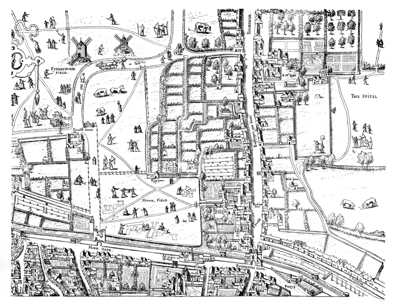
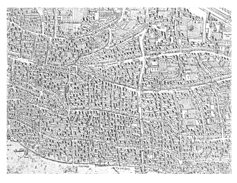
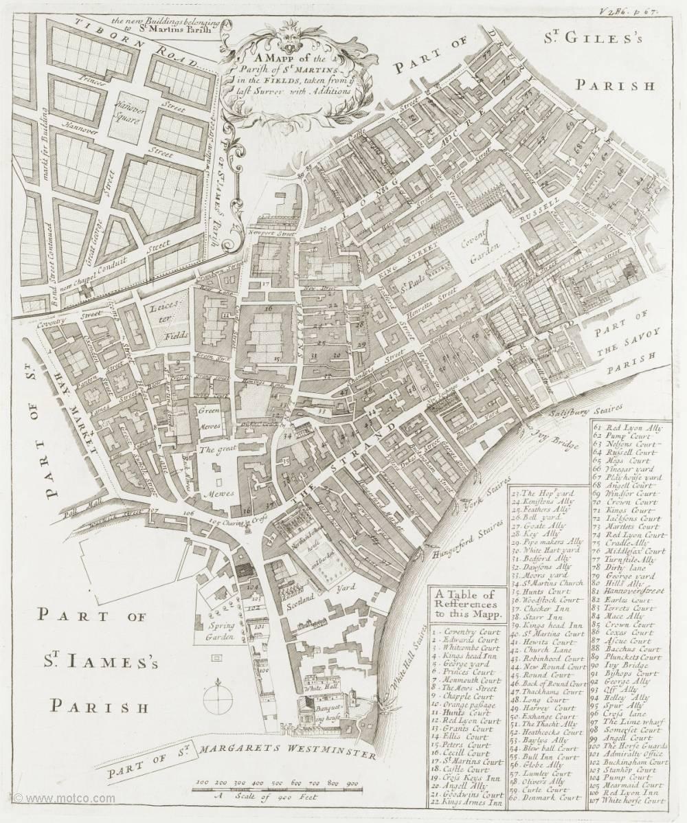
![[Full size image]](graphics/Clothworkers.jpg)